
Surveyors are accustomed to working with sophisticated and powerful technology, such as GNSS, laser scanning, and photo capture, which makes their jobs so much easier than it used to be. Even 30 years ago, gathering geometric data about the real world used…
78.7% of AEC Firms Expect Scanning/Modeling Work to Increase in the Next 12 Months
Washington D.C., August 9, 2016 — Despite swings in the global economic climate, strong growth is expected in the scanning and modeling market,…

Infrastructure Outlook: Key Points You Need to Know About Aerial Photography
By Sherry and Brett Eklund No matter the project at hand, knowledge is power. The more perspective an engineer can gain when planning or completing…
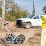
Reality Computing Goes Underground with Ground Penetrating Radar
Ground penetrating radar (GPR) is a non-destructive method for locating and mapping underground objects by transmitting high-frequency radio signals into the ground that bounce back when they hit a buried object or a boundary between different material types.…
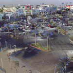
Kindle Collaboration via LiDAR-Based 3-D Smart City Models
A smart city model allows many important stakeholders, including government officials, citizens and the private sector, to easily access critical infrastructure information. But most city departments, agencies and utilities have separate processes in place…
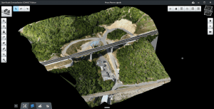
Exploring Reality Computing for Civil Infrastructure
New Reality Computing technologies that capture the physical world digitally and deliver digital information physically are changing the design, production, and management of products or projects—from cars to factories to highways. Civil infrastructure projects…

Technology-Enabled Organizational Efficiency with Greater Field-to-Office Connectivity
Higher efficiency and quality are equally needed across different industries. The global financial crisis has tightened its grip on professionals and organizations in almost all fields. As a result, several economic and environmental challenges are at play.…
