
Fast forward to today and this same process often takes just seconds. You simply open an app on your smartphone and, with a few taps on the screen, find a business, read reviews on it and get driving directions. Yes, the web has made many aspects of modern life much easier, but there is one major area that is still transitioning to this more open and responsive way of delivering information: government.
The good news is, as GIS professionals at the local (and even state) level of government, we are uniquely positioned to help this transition move faster and enable our audience (both internal and external) to more quickly find reliable and actionable information. Local government is in the business of licensing, regulating, and policing. These responsibilities naturally produce a large volume of data waiting to be made accessible and useful to the public and city staff using the power of GIS on the web. All we need to do is stay focused on what our audience needs.
Understand Its Importance
A GIS web presence isn’t a marketing gimmick designed to convince the public that a local government has suddenly embraced “Gov 2.0.” Enabling your data to be searched and viewed through a GIS interface is a fast, efficient, and intuitive way to deliver vast amounts of information to a non-technical audience. Plain spreadsheets that contain raw information posted to an obscure web page can be made infinitely more usable and understandable when displayed on a map. If a picture is worth 1,000 words, then an interactive web map must be worth 10,000!
Making data visual and interactive exposes relationships that can’t otherwise be seen. A strong, audience-centric GIS web approach supports public and staff needs for accurate information to make informed decisions. Perhaps the most important byproduct of a GIS web presence is that, through this availability of data, the public and staff can find answers to their most common questions freeing up valuable time to solve larger, more complex issues.
Identify the Audience
While developing your GIS web presence, no task is more important than identifying your audience. Who your audience is will determine not only what data you publish, but also how it is worded and in what format it is delivered. Here are a few questions you will need to ask yourself:
- Who is in your audience? - Are they city engineers looking for highly detailed and specific data or are they parents trying to find a park with the right amenities to take their kids on the weekend? Who your audience is determines how your pages and apps will look, how they are worded, and even what kinds of colors you use.
- What is the technical ability of your audience? - If the intended audience is the public, you won’t want to build a highly complex web application that takes a trained GIS professional to operate. Keep in mind how much effort your audience is willing to expend to get an answer. Chances are, if Google is simpler to use, your audience will abandon your site and go there.
- How is your audience accessing the internet? - Do most people in your area have access to high-speed internet or are many people still using dial-up? What percentage of people access your site on mobile devices? Keep in mind the strengths and limitations of different devices (e.g., support for browser plugins, low bandwidth) and the overall approach your IT department takes toward hardware manufacturers.
Knowing who you target, their abilities and how likely they are to access your site will guide how you develop your GIS web presence.
Learn the Options
Once you have a good grasp on your audience, you can begin to look at your development options. This is the process of seeing which services, software, and/or APIs have the right blend of functionality that you need for your audience. The two most commonly used frameworks in web GIS are Google and Esri.
Google: Google is best known for its search capabilities and mapping data that reaches around the globe. The Google Maps API is built on JavaScript and HTML and is the mechanism available to users to build custom GIS web applications.
Advantages:
- No cost to use the API (until you meet the hit threshold)
- Data and search services included are robust and already configured
- Well known by web users
Disadvantages:
- Not readily compatible with most commercial GIS software used by government
- The service is tied to a for-profit company that can monetize the work you build on it at any time
- There is a stigma within the GIS industry of using “canned” data and services
Esri: Esri is the global leader in commercial software development and it is the dominant technology taught to GIS students in colleges in the US and abroad. Most local governments use Esri’s desktop software for data development and analysis as well as its server software for web publishing.
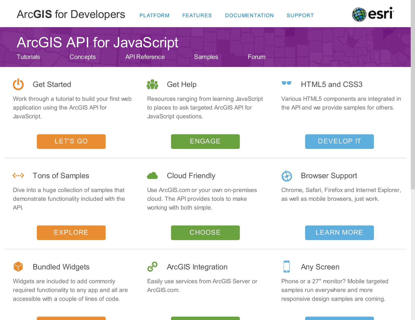
Within the Esri framework, there exist two distinct web development paths: ArcGIS Online and the three web APIs (application programming interface). ArcGIS Online is Esri’s answer to Google Maps but also includes services which publish your data into web services. Web APIs are the route that cities requiring a customized web approach using ArcGIS for Server software (which also publish your data into web services) typically take.
Advantages of ArcGIS Online:
- No cost to use if you have an enterprise license agreement (other restrictions and costs apply if data is stored within the Esri cloud, etc.)
- Point and click web development is simple and enables anyone to build a web app
- Integrates with the ArcGIS for Desktop and/or Server technology that most local governments use
Disadvantages of ArcGIS Online:
- Not easily customizable unless you download and host apps locally (you lose some of the value of ArcGIS Online once you do this)
- Service is tied to a commercial service (and pricing can change)
- Cost (if your government doesn’t have an ELA or adequate number of ArcGIS for Desktop licenses)
Advantages of the Esri web APIs:
- No cost to use the APIs
- Unlimited customization and extensibility
- Built on ArcGIS technology so there are no issues with integration between city software and the web
Disadvantages of the Esri web APIs:
- Programming experience is needed to take advantage of the APIs (or guts to learn enough about programming to make things work)
- No server software is included (users have to purchase ArcGIS for Server to get their data in the format required for the APIs)
- Flex and Silverlight APIs are browser plugins that may not run on all devices while JavaScript requires substantial debugging on various browsers to ensure stability
Your choice of service or API will depend largely on not just what you think is the best technology at the time, but also what will work best for your audience.
Knowing the GIS web development options that are available to you helps tremendously in figuring out which path to follow. Throughout this process, it is best to be honest with yourself. Do you/your web developers have the time to learn a new API or programming language? Do you have the desire to do so? Are you prepared to devote the necessary time to programming a GIS web application from scratch or do you need the application immediately?
Another consideration is to look at what other cities are doing. Look for cities that are similar to yours in size and responsibility. Do they have a GIS web presence? If so, what types of services or software are they using? What does their audience expect from their GIS web applications? What kinds of feedback have they heard after launching their apps?
In any web development, it is prudent to keep an eye on where technology is likely to head in the future. You won’t want to invest valuable time and staff resources developing a GIS web presence built on technology that is nearly obsolete. If you do, you’ll likely have to replace it quickly to keep your web apps in step with what your audience expects. This task can be made much easier when you take advantage of the web/communications staff that is already at your city.
Communicate with Staff
Web and communications staff are in the business of knowing their audience. They have a unique blend of skills that enable them to understand who their audience is and what they need. They can help you build a GIS web presence that communicates clearly with its audience, uses the right graphics and buzz words, and also deploys your web apps in ways that make them easy to find and use. Communications professionals are also very skilled in helping to highlight the good your city does. They are also very likely the best and, perhaps, the most vocal critics of your work. You need this honesty and non-GIS perspective to help you build relevant and useful apps.
Before approaching your web/communications staff about building a GIS web presence, it is best to develop a rough plan of what you would like to do. Demonstrate live examples or diagrams of the kinds of apps you want to develop. Show that you have done your research and properly vetted your audience, the technology that exists in the GIS industry, and what you and your staff and/or budget are able to support now and in the future. During the meeting, don’t speak in overly technical terms. Instead, keep things professional but casual and friendly.
Remember that building your GIS web presence is a team effort and it will take commitment from not only your GIS staff, but also your web/communications staff and the internal “owners” of your data to be successful. Take your rough plan to the meeting and work within the meeting to develop an actual plan with smart due dates for development milestones to keep everyone on track. If you run into issues, clearly communicate them and don’t be afraid to ask for a little help.
Remember, building a web GIS presence is a good thing. It should be a community effort where your audience’s needs help to guide you. By following this core principle, your apps will be a success.
Nick O'Day
Nick is currently the GIS Manager for the City of Johns Creek, Georgia. Johns Creek was incorporated on December 1, 2006, is a suburb in the north metro-Atlanta region and has grown to become a key regional player in collaborative GIS efforts in the metro area. The GIS at Johns Creek is an enterprise system and, as a result, is responsible for maintaining most of the spatial and tabular data that is used throughout the city’s operations as well as continually developing and improving web applications for the public and staff. Before coming to the City of Johns Creek, Nick worked for Fulton County, Georgia where he helped coordinate the County’s GIS migration from open-source and heavily customized applications to industry-standard hardware and programs. Nick brings over twelve years of GIS experience to Johns Creek from his time at Fulton County as well as with the University of Georgia’s Geospatial Technologies Laboratory.
Video: Crashes Drop Measurably After Rural Road Safety Improvement Project on US 521 in Lancaster County

Redevelopment of Horseshoe Bay Terminal

June Issue 2026
.jpg?width=225)