

Leica Geosystems and Develon collaborate to deliver seamless integration and precision for DD100 and DD130 dozers, enhancing efficiency and simplifying Leica MC1 3D machine control installation. (Heerbrugg, Switzerland) Leica Geosystems, part of Hexagon,…

Leica Geosystems launches lightweight GS05 GNSS Smart Antenna with tilt compensation for all-day surveying
(Heerbrugg, Switzerland ) - Leica Geosystems, part of Hexagon, today introduced the Leica GS05, a compact, lightweight GNSS Smart Antenna featuring calibration-free…

New single photon LiDAR technology boosts the efficiency of large-area airborne mapping projects
With over 14 million measurements per second, the new SPL can produce high-resolution point clouds for detailed modelling of the ground and surface features…

Leica Geosystems unveils bold new product line-up, reimagining digital construction layout
The groundbreaking Leica iCON trades solution brings industrial precision measurement technology to digital construction layout. The Leica iCON iCS50 sensor locks to the Leica vPole and its unique dot pattern for automatic detection of pole tilt, making layout…

New Leica DD300 CONNECT offers advanced utilities detection for optimised site safety
The new Leica DD300 CONNECT and DA300 Transmitter. (Heerbrugg, Switzerland) Leica Geosystems, part of Hexagon, today announced the launch of the Leica DD300 CONNECT utility locator and Leica DA300 signal transmitter, a combined, ready-to-use solution…
Leica Geosystems launches its first Machine Smart Antenna — the Leica iCON gps 120
Heerbrugg, Switzerland) Leica Geosystems, part of Hexagon, today announced the launch of Leica iCON gps 120 — a smart antenna designed to further empower construction professionals with scalable and flexible machine control solutions. The new Leica…
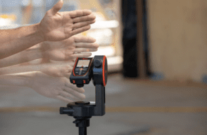
Leica Geosystems launches two new DISTO™ laser distance meters with gesture-triggered readings
Leica Geosystems, part of Hexagon, has introduced two new top-of-the-line handheld laser distance meters: the Leica DISTO™ D5 and DISTO™ X6. Powered by the latest measuring technology, the new DISTO™ models boast faster and more accurate…
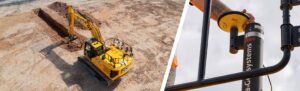
New Factory-Fitted Machine Control Solutions Launched
JCB and Leica Geosystems are joining forces to offer factory-fitted 2D and 3D-ready semi-automated excavator control solutions. (Heerbrugg, Switzerland, 20 03 2024) JCB and Leica Geosystems, part of Hexagon, today announced that they are joining forces…

John Deere and Leica Geosystems Partner to Bring New Solutions to the Construction Industry
John Deere SmartGrade™ with Leica Geosystems technology and software will be available for purchase in 2024. (Moline, USA, 15 February 2024) Today, John Deere announced a strategic partnership with Leica Geosystems, part of Hexagon, to help accelerate…
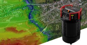
Leica Geosystems introduces Leica CountryMapper, the world’s first hybrid imaging & LiDAR sensor for large-area airborne mapping
Setting new productivity standards in the airborne mapping industry Bringing unprecedented efficiency and data quality to large-area aerial data collection (Heerbrugg, Switzerland) Leica Geosystems, part of Hexagon, introduces the Leica CountryMapper,…
