

Leica BLK product line celebrates fifth appearance since 2017 for Digital Imaging and Photography Heerbrugg, Switzerland – Leica Geosystems part of Hexagon, industry leader in measurement technology, today announced it has been named a CES® 2022 Innovation…

Leica Geosystems Announces BLK3D Update
Leica BLK3D - the in-picture measurement solution (HEERBRUGG, SWITZERLAND, 18 March 2021) – Leica Geosystems, part of Hexagon, today announced…

New Leica CityMapper-2L configuration enables digital twin creation of cities in complex weather and congested flight operation areas
With a new focal length combination for ultra-high resolution projects or operations when low flying altitude is required, the Leica CityMapper-2 now…

Leica Geosystems announces new Leica Cyclone ENTERPRISE Project Management Hub
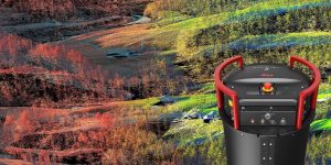
Leica Cyclone ENTERPRISE provides a next-generation universal project management hub that supports management, collaboration and deliverable creation in the desktop or on the web, in the office and on the go. New reality capture management and collaboration…

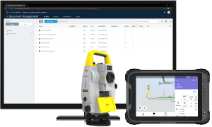
Leica Geosystems innovates automated total station portfolio
Range of automated total stations now with new integrated functionalities increase productivity in any environment (HEERBRUGG, Switzerland ) – Leica Geosystems, part of Hexagon, has enhanced the entire automated total stations portfolio in 2020. Starting…
Leica Geosystems continues airborne hybrid road map with latest modular sensor offering
Leica TerrainMapper-2 integrates LiDAR and imaging for regional mapping projects and offers simple upgrade path to oblique imaging system.(aove image) Leica TerrainMapper-2 integrates LiDAR and imaging for regional mapping projects and offers simple…

Leica Geosystems Enriches Construction Collaboration with Launch of BLK3D Web, Integrates with Autodesk
Leica Geosystems announces BLK3D Web, an online collaboration workflow that extends the Leica BLK3D imager by enabling users to share 3D measurable images with anyone, anywhere online, and the integration with Autodesk BIM 360 Docs Heerbrugg, Switzerland…
Leica Geosystems, Autodesk further collaborate to bring even more efficiency to the building construction industry
Heerbrugg, Switzerland – Leica Geosystems, part of Hexagon, announced today a new collaboration with Autodesk, integrating the Leica iCON iCT30 construction layout tool and Leica Viva TS13 and TS16, and Leica Nova TS60 and TM50 total stations with the Autodesk…

Airborne LiDAR Production Now Fully Integrated with Leica HxMap Workflow
Heerbrugg, Switzerland – Leica Geosystems, industry leader for reality capture and measurement technology, announced today the release of LiDAR data processing capability in the Leica RealCity solution package. Leica Geosystems partnered with international…
Leica Survey Uncovers Latest Insights on Use of Technology Tools in AEC Community
Norcross, Georgia – Architects, engineers and construction pros anticipate the latest technologies such as augmented reality, BIM and 3D imaging laser scanning will have a significant impact on their jobs over the next three years. Yet they have…
