
Urbano 9.0.28.0 Released!
The main focus of this release was achieving full compatibility on all AutoCAD 2017 product versions. In particular, Urbano 9.0.28.0 provides: - support for Autodesk AutoCAD 2017 products - improved pipe intersection & clash analysis tool - improved pipe topology checking tool - new system recovery tool - new element selections for protection pipes and additional network data Being the first major update since December, Urbano 9.0.28.0 includes many bug fixes and feature enhancements,...
Innovyze Releases SWMMLive and ICMLive Generation V7.0, Powering Real-Time Stormwater, Wastewater and Watershed Modeling
Broomfield, Colorado, USA — leading global innovator of business analytics software and technologies for smart wet infrastructure, today announced the worldwide release of the V7.0 Generation of its SWMMLive and ICMLive for real-time operational forecasting, modeling and management of urban drainage systems. The latest release sets the scene for the next quantum leaps in smart water modeling, giving wastewater utilities an unsurpassed tool for operating and managing their collection systems, ide...
Drone Mapping Software Provider Pix4D Elevates Agriculture Software to Desktop & Cloud Solution, Launches Flexible Monthly Rental Option at InfoAg
Today Pix4D announces its first hybrid processing solution: this week, users of Sequoia with a license of Pix4Dmapper Ag will be able to process both locally in Pix4Dmapper Ag and on the Pix4Dcloud. Together with this announcement, Pix4D also introduces very flexible monthly (149 USD) and yearly (1490 USD) plans for its Pix4Dmapper Ag solutions. This new strategy comes from seeing the need in the agriculture industry for more flexible processing options to facilitate competitive operations. W...
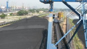
Successful Commissioning of Heap Profile and Volume Measurement System at ADANI
Further two reclaimers have been equipped with 3D laser measurement system at ADANI ports in Mundra, India. The system also includes a specific manager application, where a segmentation of multiple piles is shown as well as volume and weight information. A high reusability for further projects was concluded. The system for heap volume measurement determines information like e.g. volume, 3D profile, peaks by using 3D laser scanners from the LASE 3000D-S-13x Series, which are installed on top o...

AirGon LLC Revolutionizes Drone Data Extraction
Huntsville, AL – AirGon LLC, a wholly owned subsidiary of GeoCue Group, Inc., announces the launch of Topolyst™, an advanced desktop application designed to make easy work of extracting information and derived products from point cloud and/or LIDAR data collected by drones over construction and mining sites. The return on investment of Topolyst is almost immediate - site data collections that used to take days are now completed in hours with Topolyst’s strong complement of automated tools. Ap...

Autodesk Launches LIVE: Brings Interactive Storytelling to Life
SAN FRANCISCO, Calif., July 21, 2016 — Autodesk, Inc. (NASDAQ: ADSK) today announced the launch of Autodesk LIVE, a new interactive visualization service which offers Revit users in the architecture, engineering and construction industries (AEC) the ability to transform their designs into fully-interactive 3D models. Previously known as “Project Expo,” the Autodesk LIVE experience draws viewers into the story of an architectural design much like a video game. With one click in Revit, Autodesk...
NGRAIN Announces Open-Source Viewer for Android, Enabling Fast Creation of 3D Industrial Applications on Smart Glasses
Vancouver, BC, Canada – NGRAIN today announced the availability of NGRAIN Viewer for Android, a new app for Android tablets and smart glass devices, enabling the deployment of industrial 3D content created with NGRAIN Producer Pro. NGRAIN Viewer for Android offers organizations working with heavy equipment, assemblies, and other industrial assets in the field, the opportunity to easily explore possible use cases for smart glasses and 3D content without the need to invest in the development of...
LandWorks Tightens Integration with Esri in Land Management Software Upgrades
HOUSTON, TEXAS, July 19, 2016 – LandWorks Inc., a developer of innovative land management solutions, today introduced Release 5.50 of its three primary software suites – LandWorks Property Management, LandWorks GIS, and WebMaps Enterprise GIS. All three have been re-written for easier use, greater functionality, and to fully support the Esri® ArcGIS® platform. Details on Release 5.50 may be found at http://www.landworks.com/products/. “In Release 5.50, we’ve fully integrated all of our GIS...

Contech Engineered Solutions Releases a New Stormwater Design Tool
Contech Engineered Solutions launched a new on-line program for designing stormwater detention and infiltration systems constructed from Contech corrugated metal pipe (CMP). The new tool will allow engineers to quickly prepare designs for estimates and project meetings, and be more efficient with their time. The free tool is available at www.conteches.com/dyods. The new tool, known as the Design Your Own Detention System (DYODS®) tool, fully automates the layout process for stormwater detent...

New AVEVA Engage Redefines Engineering Decision Support
Dubai, UAE, Oct. 21, 2015—AVEVA today announced AVEVA Engage, a unique collaborative decision-support solution for capital projects and operating assets. It combines the power of instant access to a Digital Asset’s full contextually-integrated information with an impressively simple and entirely intuitive touch-driven interface, all visualised and navigable in a striking Ultra-High Definition (UHD) whole-model view. Part of AVEVA’s ‘Future of Decision Support’ programme, AVEVA Engage is bringing...
Video: New Roundabout Under Construction at McIver and Old Florence Roads in Darlington County

New Franklin City Hall

June Issue 2026
.jpg?width=225)