Wingtra achieves a key accuracy milestone with terrestrial laser scanner data comparison
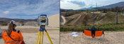
Zurich, Switzerland — Swiss survey firm Lerch Weber recently conducted an accuracy study comparing Trimble SX10 terrestrial laser scanner (TLS) data to that captured by the WingtraRAY survey drone equipped with its SURVEY61 sensor. The study, published as a case on Wingtra’s website, found the most clear alignment of data accuracy so far when comparing ground-based and drone-acquired survey data. Specifically, Lerch Weber conducted a survey of a 20 ha (40 ac) gravel pit in Lostorf, Switzerland u...

AQ Matic Valves & Controls Highlights F Series Inline Flow Meter for Accurate, Low-Maintenance Water Measurement
Ultrasonic, stainless steel, service‑friendly design delivers reliable, low‑maintenance performance in demanding water and industrial applications AQ Matic Valves & Controls, a leading manufacturer of precision, US-crafted valves, controls, and related components, highlights the F Series Inline Flow Meter, an ultrasonic flow meter engineered to elevate water treatment and usage measurement in a wide range of industrial and commercial applications. Designed for accurate flow monitoring, long se...

HERE WeGo brings real-time traffic intel to soccer fans across North America
Free navigation app integrates public transit, live traffic, road closures and AI-based re-routing to support match day travel and nearby communities As millions of fans travel across North America for the world’s biggest soccer tournament, HERE Technologies, the world’s leading mapping and location technology company, is helping them get around the stadiums and local communities with the HERE WeGo app. Large-scale events bring sudden road closures, heavy congestion and rapidly-changing traffic...

Maxon Brings Real-Time Architectural Visualization to AIA26 With New Redshift for Revit and Archicad Integration Beta
Architects and interior designers can experience live demos of Redshift for Revit, Archicad, and Vectorworks at the Nemetschek booth. BAD HOMBURG, Germany – June 10, 2026 – Maxon, a leading developer of powerful and intuitive 2D and 3D software and complete graphic design solutions, today announced that Redshift now integrates with Autodesk Revit® to create seamless architectural 3D visualization. Redshift for Revit brings Maxon’s signature real-time, ray-traced rendering directly into one of th...
NWPX Park Showcases Integrated Fuel‑Water Separation and Foam Containment Solutions for Modern Heliports and Aviation Facilities
Unified systems enhance safety, environmental protection, and year‑round reliability across rooftop, airfield, and hangar operations NWPX Park, a division of NWPX Infrastructure, a global leader in the design and construction of innovative water utilities and environmental solutions, is proud to highlight its HeliCepter® Fuel‑Water Separator System and FoamTrooper™ Fire Fighting Foam Containment System. The two integrated solutions are engineered to help aviation facilities protect stormwater...

Topcon brings latest innovations to GEO Business in London
Topcon Positioning Systems took to GEO Business in London this month to showcase the latest solutions making geospatial workflows more efficient, accurate, safe, and cost-effective. The event, which took place at Excel London from 4-5 June, saw Topcon exhibit recently released hardware, software and workflow technologies across capture reality, surveying solutions, engineering survey, and GIS mapping and utilities. This included the company’s new suite of 3D scanning solutions which with integra...

Bluebeam Accelerates AI Strategy with New Bluebeam Max Capabilities and mbue Acquisition
New collaboration features and targeted technology investment strengthen Bluebeam Max and deliver greater value for AEC teams Pasadena, Calif. (June 9, 2026) – Bluebeam, a leading developer of solutions and services for architecture, engineering, and construction (AEC) professionals and part of the Nemetschek Group, today announced a new wave of product innovations that expand the capabilities of Bluebeam Max, introduce enhanced collaboration features, and build on its growing momentum in deliv...

Arcadis and Jupiter Intelligence introduce PRICE framework to help organizations close the climate adaptation investment gap
June 2026 – Arcadis (EURONEXT: ARCAD), a global leader delivering data-driven sustainable design, engineering, and consultancy solutions for natural and built assets, and Jupiter Intelligence, the global standard for extreme weather risk and adaptation analytics, today launched the PRICE Adaptation Framework, a decision-grade methodology designed to help organizations compare climate adaptation options, quantify return on investment and prioritize resilience spending. The launch comes as organiz...

Q-Free Launches Dynamic® CV Connected Vehicle Module for Dynamic Software
Dynamic CV combines connected vehicle functionality with modern cybersecurity protections to help both agencies and drivers manage intersections. CHESEPEAKE, Virginia – Q-Free, a global leader in mobility solutions for smart city infrastructure today announced the launch of Dynamic CV, the connected vehicle (CV) software module for Q-Free’s cybersecurity-first Dynamic Software. Designed to help transportation agencies secure connected intersection technology in an increasingly complex threat lan...

Leica Geosystems’ new Leica RTC series sets the benchmark in scanning accuracy and productivity
Industry-leading sensors paired with a real-time collaboration workflow let teams scan faster, start collaborating immediately, and keep projects moving towards deliverables Advanced 3D laser scanning: The new Leica RTC laser scanners capture data faster and 35% more accurately than its nearest competitor. Real-time collaboration: Industry-first Livelink capability enables project teams to connect and collaborate during scanning, so they can spot data gaps before they leave the site and start wo...
Video: New Roundabout Under Construction at McIver and Old Florence Roads in Darlington County

New Franklin City Hall

June Issue 2026
.jpg?width=225)