
FARO Releases SCENE Version 6.1, Introducing a Fully Integrated Point Cloud to 3D Mesh Engine for Product Design and Construction BIM-CIM Professionals
LAKE MARY, Fla. - FARO® (NASDAQ: FARO), the world's most trusted source for 3D measurement and imaging solutions for factory metrology, product design, construction BIM/CIM, public safety forensics and 3D solutions and services applications, announces the release of SCENE 6.1, the next generation of its powerful software for efficiently processing and managing 3D laser scan data. For modeling freeform shapes such as statues, equipment, industrial components and buildings, SCENE 6.1 now offer...
Bringing the Civil Engineering Office to the Field Speeds Approvals and Helps Resolve Issues During Design, Construction, and Operations
Bentley Systems announces OpenRoads Navigator CONNECT Edition, an innovative application that provides civil and transportation professionals an easy-to-use, dynamic product for quick access to civil design information in the field. OpenRoads Navigator supports Windows, iOS, and Android. Key capabilities include: View, analyze, and augment a wide variety of project information, including geometry, 3D models, and 2D topography. Search and filter models based on attributes such...

Trimble Connected Mine Provides Spatial Data Visualization Using Trimble and Microsoft Mixed-Reality Technologies
SUNNYVALE, Calif. —Trimble (NASDAQ:TRMB) announced today the release of its Trimble® Connected Mine™ Visual Intelligence module with support for mixed-reality technology including Microsoft HoloLens to provide visual collaboration of mine spatial data. Trimble Connected Mine is an integrated and complete view of mine data to improve and accelerate operational and strategic decision making. Visual Intelligence is an optional module that enables the 3D visualization of Trimble Connected Mine da...
Buckeye Mountain and Trimble Partner to Bring Mobile Computing, GPS and AEI Tag to Railways
NIWOT, Colo.- Buckeye Mountain and Trimble have been working together in an effort to provide the railroad industry with products that meet their specific needs for mobile computers, AEI (railcar automatic equipment identification tags) and GPS. Trimble's Juno® T41 R-AEI, an all-in-one rugged AEI reader, is a compatible platform for Buckeye Mountain's AEI Quick Read application, a simple and basic mobile application that reads AEI tags. Trimble has the unique c...
Quickly Produce Conceptual Roadway Designs
Bentley Systems announces OpenRoads ConceptStation, a conceptual modeling application that empowers highway engineering professionals to quickly create conceptual road and bridge models in a matter of hours – not days. OpenRoads ConceptStation enables rapid and iterative conceptual and preliminary design, leveraging contextual information obtained through point clouds, reality meshes, GIS, and other sources. OpenRoads ConceptStation combines engineering drawing tools and project costs to...
Exprodat Increases Oil & Gas Workflow Integration with Updated Data Assistant
Exprodat, the oil and gas ArcGIS platform specialist, Esri Gold Partner and Getech group company, has released the latest version of its popular Data Assistant software, which simplfies and speeds up the process of importing and exporting common exploration data, to and from Esri’s ArcGIS platform. Data Assistant v222 is now compatible with ArcGIS Desktop 10.4 and 10.4.1 which means those people working with the latest Esri software versions will be able to benefit from easily importing cruci...
UTGIS Launches Mobile Electrical Safety Testing for IEEE 1695™ Contact Voltage Programs
PORT ST. LUCIE, Fla., — Utility Testing and Geographic Information Systems (UTGIS) announced today the launch of their Mobile Electrical Safety Testing (MEST) program. The MEST program is designed for utilities and municipalities interested in identifying and resolving contact voltages on their electrical infrastructure assets. "Contact voltage" defined by the new IEEE 1695 Guide to Understanding, Diagnosing and Mitigating Stray and Contact Voltage, is any fault voltage potential between two...
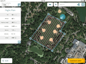
Datumate Unveils DatuFly, A Professional Imagery App for Drones
YOQNEAM, Israel, September 6, 2016 - Datumate, a market leader of automated "Field-to-Plan" solutions that save costly field and office time, is pleased to announce a new tablet app for effortless drone flight planning and automated, high resolution photo-shooting. DatuFly™ app saves up to 80% of field surveying time and eliminates follow-up site visits. "DatuFly™ automates the entire field surveying process, while keeping field work simple and safe," says Tal Meirzon, Datumate CEO. "Ease of...
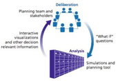
RAND and Lawrence Livermore National Lab Combine High Performance Computing and Public Policy Analysis for Demonstration of Water Resource Management
Researchers from the RAND Corporation and the Lawrence Livermore National Laboratory have joined forces to combine high-performance computing with innovative public policy analysis to improve planning for particularly complex issues such as water resource management. Building on previous work conducted by RAND on the Colorado River Basin in 2012, RAND and the High Performance Computing Innovation Center at Lawrence Livermore National Lab hosted a joint workshop to employ high-performance...

New SphereVision 360 Imaging Software Integrates iSTAR Measurement Module
Shepperton Studios, London – Arithmetica has released a new version of the SphereVision 360 degree imaging software with support for NCTech’s industrial grade iSTAR panoramic camera. SphereVision Project Builder now includes brand new functionality, allowing iSTAR users to capture measurements directly from within a spherical image. With applications including forensic evidence collection, as built surveying, asset management and construction, for example, this new functionality is designed for...
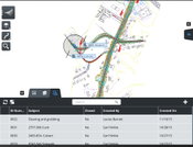
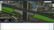
Video: New Roundabout Under Construction at McIver and Old Florence Roads in Darlington County

New Franklin City Hall

June Issue 2026
.jpg?width=225)