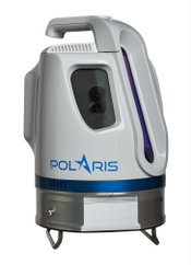
Introducing Polaris — Next-Generation Terrestrial Laser Scanner
Teledyne Optech is pleased to announce the release of its Polaris Terrestrial Laser Scanner at the SPAR 3D Conference and Expo, April 3-5, in Houston, Texas. This versatile, productive and user-friendly scanner will be on display in booth #400 along with the Optech Maverick, Eclipse, and award-winning Galaxy. Bridging the gap between indoor and outdoor scanners, the Polaris can survey targets up to 1600 m away in long-range mode or collect up to 500,000 measurements per second in short-r...
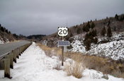
Traffic Sensors Will Aid Traffic Flow on I-15 During Upcoming Construction
POCATELLO – To aid traffic flow for tens of thousands of drivers during upcoming construction on Interstate 15 in eastern Idaho, the Idaho Transportation Department (ITD) is turning to new technology. Bluetooth-based roadway sensors in the Interstate 15 median will provide real-time travel information during construction starting later this spring. Between this spring and next year, ITD will resurface deteriorated pavement on I-15 and make numerous bridge repairs. Construction will include m...

Autodesk Previews Enhancements for Advance Steel and Steel Connections for Revit at NASCC 2017
By Udo Haedicke and Michael Gustafson Autodesk Revit and Advance Steel better connect structural design and fabrication Since acquiring Advance Steel in 2013, Autodesk continues to work towards better support for BIM-centric workflows for structural steel design and detailing. For instance, we have been working to strengthen the interoperability between Autodesk Revit design software and Autodesk Advance Steel software. In advance of tomorrow’s opening day of the NASCC conference, we’re happ...
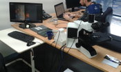
Asbestos Detecting Technology to Protect Construction Workers
A ROBOTIC microscope has been developed to test air quality at demolition sites to protect workers from deadly asbestos fibres. Marvin is an analysis program developed by Frontier Microscopy in South Australia that eliminates manual processing of dangerous minerals. It uses artificial intelligence and a robotic microscope to screen air samples for asbestos fibres in a fraction of the time it takes humans. Frontier Microscopy will make Marvin commercially available within the next two mo...
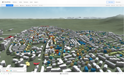
New CloudCities Brings Procedural Terrain and Advanced Search
San Francisco/Zurich, March 15, 2017 — CloudCities today announced an update to the platform bringing procedural terrains and advanced search features. The new CloudCities is now available at cloudcities.io. CloudCities is a Cloud Platform for Building Insights. CloudCities helps architecture, engineering and construction (AEC) professionals and their clients learn from their data. It dramatically simplifies creating 3D plans and combining data with it. With the new version, models can be imm...

Introducing AutoTURN Online - The Premier Swept Path Analysis Solution through Your Browser
Looking for an easier way for performing vehicle checks on any type of plan view, aerial photo or even a rough conceptual sketch? Need to evaluate many vehicle access and circulation alternatives for value engineering purposes? Then don't miss this chance to see how AutoTURN Online enables you to make quicker analyses and decisions earlier in the design stage. With AutoTURN Online, you can work with virtually any CAD platform — all you need is an internet connection — there's nothing to install!...

Parrot Bebop-Pro 3D Modeling
Parrot, the pioneer of the civil drone market, announces a new all-in-one aerial imagery and 3D modeling solution for real-estate and building professionals, the ‘Parrot Bebop-Pro 3D Modeling’ pack. The pack includes a Parrot Bebop 2 drone with Parrot Skycontroller 2 remote control, Pix4Dcapture app, which automatically captures aerial images, as well as Pix4Dmodel software to process images and create a 3D model. Easy to use, reliable and affordable, the Parrot Bebop-Pro 3D Modeling pack is...
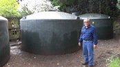
American Manufacturer Makes History In Rainwater Harvesting
ROSEVILLE, California: Gutterglove announces that their manufactured gutter guards are the first in history to receive certification through Underwriters Laboratories (UL) for NSF P151 and NSF 372. There are over 100 gutter guards manufactured today, and this approval will allow their gutter covers to be the first to be used in potable rainwater harvesting systems. Even with all the rains as of late, there will still be a growing demand for water conservation practices and sustainable eco-fri...

POWER360 Upgrade Cuts Software Costs, Increases Security
HAILEY, Idaho — POWER Engineers Incorporated (POWER) has launched the latest version of its robust project management tool. POWER360® reduces software costs and increases data security as well as strengthens the ability of utility, generation and telecommunication managers to oversee critical infrastructure projects. POWER360 enables teams, contractors, public agencies and other stakeholders to make informed decisions because they can access a single source of accurate information faster. “Fro...
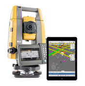
Topcon Announces Enhanced Integration of GT Series Total Stations with Autodesk
LIVERMORE, Calif., USA/ CAPELLE A/D IJSSEL, The Netherlands – Topcon Positioning Group announces a new integration that extends its compatibility with Autodesk solutions. The Topcon GT series of robotic total stations is now available for use with Autodesk BIM 360 Layout software. “A new update allows GT instruments to seamlessly connect with the BIM 360 Layout application that provides operators the ability to connect coordinated models to the field layout process, helping to increase job si...
Video: New Roundabout Under Construction at McIver and Old Florence Roads in Darlington County

Promenade at The Point

June Issue 2026
.jpg?width=225)