
CAD Interior Design Tool Expands into Europe
A WORLD-first augmented reality tool is being expanded into Europe to create designs for everything from hospital emergency departments to factories. Building upon a regular Computer Aided Design (CAD) plan, the patented CADwalk system uses software to display an image of a room on to a large wall screen and project the floor plan on to the floor in actual size. First developed with the help of the Wearable Computer Lab at the University of South Australia, CADwalk Global was previously kn...

Cortec Corporation Awarded 63rd Patent in 40 Years of Business!
Cortec® Corporation is pleased to announce the formal patenting of its CorroLogic Filler! US Patent #9,518,328 was granted to Cortec Corporation on December 13, 2016, in recognition of the novelty of CorroLogic VpCI Filler. This is the 63rd patent that has been awarded to Cortec Corporation since its founding almost 40 years ago in late 1977. It is yet another example of the innovative solutions Cortec creates to fit the specific needs of its customers. CorroLogic® VpCI® Filler was designed...

New Technology by Michael Baker International Empowers City of Richmond to Visualize Change and Establish a More Connected Transit System
Michael Baker International, a global leader in engineering, planning and consulting services, is helping residents and city officials in Richmond, Va., rethink the design of the Greater Richmond Transit Company (GRTC) bus system and establish a more connected transit network through the innovative use of technology. To assist the community in visualizing various transit options and to identify a more effective system, Michael Baker planning experts developed a unique Geographic Information Syst...
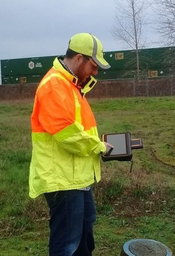
Oregon Department of Transportation Deploys DT Research Purpose-built GNSS Rugged Tablets for Construction Projects
SAN JOSE, CA - DT Research, the leading designer and manufacturer of purpose-built computing solutions for vertical markets, today announced the successful deployment of the DT391GS Rugged GNSS Tablets for the Oregon Department of Transportation (ODOT). The DT391GS tablets with Intel® Celeron® Dual Core Processors are used as Inspector Positioning Tablets with the critical hardware and software needed for line and grade determination on stakeless highway construction projects. ODOT needed to...

Viewpoint Construction Software Announces Viewpoint Team, its Next- Generation Collaboration Platform
PORTLAND, OR – – Last week Viewpoint Construction Software® launched Viewpoint Team, a fully collaborative, cloud-based platform for project management and construction operations solutions. Viewpoint Team integrates with Vista, Viewpoint’s core ERP product, and is browser and mobile friendly. The first application to launch in Viewpoint Team is Submittals. The Team Submittals solution streamlines the complex submittal process, ensuring all stakeholders can review, comment and approve documen...
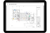
Autodesk BIM 360 Docs Now Available For Android Devices
If you attended Autodesk University in Las Vegas in November, you’ll recall that during the Product Innovation Keynote, Sarah Hodges, Autodesk’s Construction Business Line Director, made reference to upcoming BIM 360 Docs support for Android devices. That day has come, and BIM 360 Docs now offers Android device users with a mobile construction app to access the latest project files and information. Previewed at Autodesk University 2015, Autodesk BIM 360 Docs provides a long-awaited answer to...

IMAGINiT Technologies Offers Intelligent Construction Technology from Leica Geosystems
OWINGS MILLS, MD - Rand Worldwide (OTCBB: RWWI), a global leader in providing technology solutions to organizations with engineering design and information technology requirements, announced that its IMAGINiT Technologies division expanded their sales and training offerings from Leica Geosystems. The expanded offering includes robotic total stations, controllers and other hardware and software solutions from the industry-leading Leica iCON (intelligent construction) portfolio. These solutions ar...

Natural Resources Wales Taps CH2M's Flood Modeller Pro for its New Flood Forecasting System
DENVER - Natural Resources Wales, the Welsh Government's principal adviser on issues relating to the environment and its natural resources, selected CH2M's Flood Modeller Pro software as the core hydrodynamic modelling solution within its new flood forecasting system. The system is being built using Deltares' Delft-FEWS software, an open data handling platform, designed for building a customized hydrological forecasting system. "Flood forecasting is an essential component of flood risk manage...
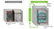
Siemens To Use Meidensha’s Ceramic Flat-Sheet Membrane For The First Time In Newly Developed PACT MBR System
Shinagawa, Tokyo | Meidensha Corporation (CEO Yuji Hamasaki; Shinagawa, TOKYO) today announced that the company’s ceramic flat-sheet membrane has been accepted by Siemens Water Solutions for use in its new PACT® Membrane Bioreactor (MBR) used for waste water treatment in the oil refinery and petrochemical industries, and other challenging wastewater treatment environments. The next generation PACT® system, set to be marketed around the globe, produces best-in-class wastewater treatment effluent...

Hitachi Consulting Launches End-to-End Water Management Solutions
DALLAS - Hitachi Consulting, a subsidiary of Hitachi, Ltd (TSE: 6501) and a leading provider of IT consulting and management consulting solutions and services, has launched a comprehensive water management solution to accelerate enterprise sustainability initiatives. Hitachi Consulting Water Management Solutions tailor water management services with an innovative approach that includes detailed assessments, leading technologies and equipment implementation, as well as water management intelligen...
Video: New Roundabout Under Construction at McIver and Old Florence Roads in Darlington County

Promenade at The Point

June Issue 2026
.jpg?width=225)