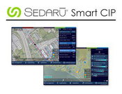
Sedaru Deploys Smart CIP, Advancing the Connected Utility, Empowering Integrated, Dynamic Asset Management for Water/Wastewater Systems
/ / / / ARCADIA, Calif. - IDModeling, Inc. the leading global provider of smart water software and services, announced today the deployment of Smart CIP™ for integrated, dynamic asset management of water & wastewater systems. Sedaru's Smart CIP technology provides a lightweight, sophisticated, enjoyable-to-use platform for utilities to connect their data, experience, and institutional knowledge to quantify and prioritize capital improvement projects (CIPs) to consistently measure and increas...

TomTom’s HD Map Powers Autonomous Driving
MELBOURNE, Australia - ITS World Congress – TomTom (TOM2) today announces a joint autonomous driving demonstration with Bosch. TomTom provided its HD Map and RoadDNA technology to setup a demonstration on the Australian F1 Grand Prix circuit at Albert Park; these novel products are important components to enable Bosch’s demo vehicle to perform in autonomous driving mode. TomTom HD Map and RoadDNA are two revolutionary, highly accurate digital map based products helping automated vehicles precise...
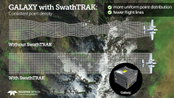
Teledyne Optech Announces New Efficiency Enhancement for ALTM Galaxy Wide-Area Lidar Mapping Sensor
Teledyne Optech is pleased to announce a high-performance scanner update to its innovative line of airborne laser terrain mappers, the Optech Galaxy ALTM™. The Galaxy’s scan efficiency has been engineered to deliver an additional 30% boost to its class-leading area coverage rates. When coupled with its innovative SwathTRAK™ and PulseTRAK™ technologies, collection efficiencies exceeding 70% are possible, relative to the traditional fixed-FOV dual-beam sensors currently on the market. According...
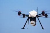
InterGEO2016: AltiGator and YellowScan Unveil a 5.6kg Survey-Grade LiDAR UAV all Integrated System, Ideal for Centimetric Urban Surveys
AltiGator and YellowScan are pleased to announce an ultra-light weight LiDAR UAV combo allowing for the first time centimetric UAV surveys in urban areas, in accordance with most regulations. The YellowScan Surveyor ultra-light stand-alone LiDAR system is embedded on the OnyxStar® XENA multirotor UAV, which is the last generation professional drone designed by Altigator. Compact, light, powerful and foldable, Xena is the result of the analysis of users' operational needs and months of Rese...
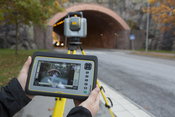
Trimble Unveils SX10 Scanning Total Station for Surveying, Engineering and Geospatial Professionals
SUNNYVALE, Calif., - Trimble (NASDAQ: TRMB) unveiled today a next-generation survey instrument—the Trimble® SX10 Scanning Total Station. It merges high-speed 3D scanning, enhanced Trimble VISION™ imaging technology and high-accuracy total station measurements into familiar field and office workflows for surveyors. The innovative solution provides surveyors and geospatial professionals with the capabilities and versatility to handle projects from traditional surveys to complex 3D modeling. The...
Autodesk LIVE now supports HTC Vive or Oculus Rift
Autodesk brought “on demand” interactivity to the architecture, engineering and construction (AEC) industries when we introduced Autodesk LIVE for Autodesk Revit in July. LIVE is the game-changing, cloud-based service that transforms your Revit model into an interactive experience, in just one click. Rather than just seeing your model, LIVE lets you experience it. If one click automates complex Building Information Modeling (BIM) data processing, what could Autodesk achieve with a second...
senseFly to Unveil New RTK/PPK-Ready, Large Coverage Mapping Drone at INTERGEO 2016
Cheseaux-Lausanne, Switzerland – senseFly, the world’s first choice producer of professional mapping drones, will introduce its next-generation fixed-wing system for survey-grade photogrammetric mapping, the eBee Plus, at INTERGEO 2016 on Oct. 11 in Hamburg, Germany. “The eBee Plus system is the ultimate tool for geospatial organisations that demand photogrammetric-quality mapping,” said senseFly’s CEO, Jean-Christophe Zufferey. “With its unique upgradeable RTK/PPK functionality and fli...

DTS and SmarterBetterCities Partnership Extends 3D to Asset Management
San Francisco, Calif. – DTS and SmarterBetterCities are pleased to announce a partnership that brings 3D tools and sharing to asset management. The world is not flat. Why run an asset management system that only allows you to track work management, perform condition assessments and generate projects for a capital improvement plan in the second dimension? This partnership will make the interaction with VUEWorks both richer and more intuitive. Using VUEWorks and CloudCities together brings many...

Contech's UrbanGreen Rainwater Harvesting Tank Receives Uniform Plumbing Code Certification
WEST CHESTER, Ohio, Oct. 3, 2016 - West Chester-based Contech Engineered Solutions announced today that the UrbanGreen Steel Reinforced Polyethylene Rainwater Harvesting Tank has been certified to be in compliance with the Uniform Plumbing Code (UPC®) by The International Association of Plumbing and Mechanical Officials (IAPMO) Research and Testing. Designated as an American National Standard, the UPC is a model code developed by the International Association of Plumbing and Mechanical Offici...

SITECO Partners with Pavemetrics Inc., Launching Pave-Scanner, the First Infrastructure and Pavement Inspection System
Bologna, Italy - SITECO Infomatica SRL has completed integration of the Pavemetrics vision system technology product lines onto the SITECO Road-Scanner hardware and software platforms. This partnership has made available the first commercially available true 360 degree infrastructure and pavement surface inspection system. This new Laser Automated Road Analyzer system, called the PAVE-Scanner, is already deployed and in use in the EU. SITECO brings it’s iRAP Accreditation Specification fo...
Video: New Roundabout Under Construction at McIver and Old Florence Roads in Darlington County

New Franklin City Hall

June Issue 2026
.jpg?width=225)