

Theme is quality and performance enhancements to empower designers with simplicity needed to design the complex Columbia, MD —Global design and BIM software provider Vectorworks, Inc. has launched Vectorworks 2021 with a continued emphasis on improving…

Eos Positioning Systems announces compatibility of Eos Locate™ for ArcGIS with Subsite® Electronics Products
The expansion makes the Eos Locate™ for ArcGIS, an underground asset-mapping solution, compatible with Bluetooth-enabled Subsite UtiliGuard® and UtiliGuard…

DuroMaxx® SRPE From Contech® Approved By AREMA
Direct-Bury and Reline Applications Added to Manual for Railway Engineering West Chester, OH – Contech® Engineered Solutions announced…
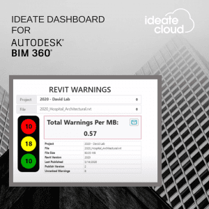
Manage Revit Warnings within the Autodesk BIM 360 Environment with New Service from Ideate Software
San Francisco, CA – Ideate Software, a veteran Autodesk® AEC Industry Partner, announces the launch of Ideate Dashboard for Autodesk® BIM 360®, a data visualization service that uses proprietary technology to provide information related to Revit warnings…

Bentley Systems Announces Availability of OpenGround Cloud to Increase the Value of Geotechnical Data
Going digital from ground to cloud with OpenGround Cloud offers advanced digital workflows for improved efficiency. (Image) New Cloud Service Assures Data Integrity for Geotechnical Information Management EXTON, Pa. – September 10, 2020 –…

Esri Acquires nFrames to Enhance Its 3D Capabilities
Esri Will Offer World-Class 3D Surface Imaging Technology and Integrate into the ArcGIS Platform REDLANDS, Calif.—September 9, 2020—Esri, the global leader in location intelligence, today announced the acquisition of nFrames, a technology company…

HP Launches The World’s Easiest Plotters for Architect, Engineer, Construction and Home Offices
News highlights: Simple to operate: Print multi-size projects automatically and send multiple files in one click with HP Click, all without compromising on speed.1 Fits your office and budget: Save space and make a statement with the world's smallest plotters2…
Golden Software Improves Surfer® File Handling for Faster Mapping
Create pie charts in Surfer showing proportions of attribute data for each feature (Above Image) GOLDEN, Colorado – Golden Software, a developer of affordable 2D and 3D scientific modeling packages, has made it faster and easier than ever to create…
Tech Companies ShapeDiver and Thornton Tomasetti’s Swarm Merge to Become the Largest Cloud-Based SaaS Platform for Accessing and Sharing Parametric Designs
Merger Drives Innovation in A/E/C Process and Product Design in All Industries, Occurs in Tandem with Investment by Thornton Tomasetti in ShapeDiver New York/Vienna – Technology companies ShapeDiver and Swarm, leaders in the development of cloud-based…
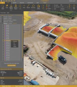
Virtual Surveyor Offers Enhanced Functionality in Free Version of Drone Surveying Software
AARSCHOT, Belgium, 8 September 2020 – In release 7.4, Virtual Surveyor has added new functionality to the free pricing level of its popular drone surveying software. The “Valley” plan of Virtual Surveyor now allows users to create engineering CAD models…
