
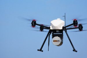
AltiGator and YellowScan are pleased to announce an ultra-light weight LiDAR UAV combo allowing for the first time centimetric UAV surveys in urban areas, in accordance with most regulations. The YellowScan Surveyor ultra-light stand-alone LiDAR system is…
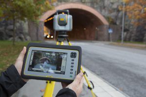
Trimble Unveils SX10 Scanning Total Station for Surveying, Engineering and Geospatial Professionals
SUNNYVALE, Calif., - Trimble (NASDAQ: TRMB) unveiled today a next-generation survey instrument—the Trimble® SX10 Scanning Total Station. It merges…
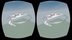
Autodesk LIVE now supports HTC Vive or Oculus Rift
Autodesk brought “on demand” interactivity to the architecture, engineering and construction (AEC) industries when we introduced Autodesk LIVE for…
senseFly to Unveil New RTK/PPK-Ready, Large Coverage Mapping Drone at INTERGEO 2016
Cheseaux-Lausanne, Switzerland – senseFly, the world’s first choice producer of professional mapping drones, will introduce its next-generation fixed-wing system for survey-grade photogrammetric mapping, the eBee Plus, at INTERGEO 2016 on Oct. 11 in…

DTS and SmarterBetterCities Partnership Extends 3D to Asset Management
San Francisco, Calif. – DTS and SmarterBetterCities are pleased to announce a partnership that brings 3D tools and sharing to asset management. The world is not flat. Why run an asset management system that only allows you to track work management, perform…
Contech’s UrbanGreen Rainwater Harvesting Tank Receives Uniform Plumbing Code Certification
WEST CHESTER, Ohio, Oct. 3, 2016 - West Chester-based Contech Engineered Solutions announced today that the UrbanGreen Steel Reinforced Polyethylene Rainwater Harvesting Tank has been certified to be in compliance with the Uniform Plumbing Code (UPC®) by…

SITECO Partners with Pavemetrics Inc., Launching Pave-Scanner, the First Infrastructure and Pavement Inspection System
Bologna, Italy - SITECO Infomatica SRL has completed integration of the Pavemetrics vision system technology product lines onto the SITECO Road-Scanner hardware and software platforms. This partnership has made available the first commercially available…
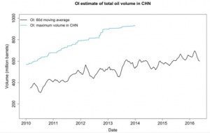
Orbital Insight Measures China Oil Supply With Satellite Imagery Analysis
Orbital Insight, a US-based geospatial analytics and software company, today announced the general availability of China Oil, the latest addition to its global oil supply monitoring tools. Using a proprietary combination of machine learning and computer vision,…
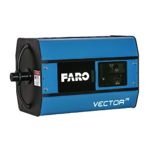
FARO Disrupts In-Process Guided Assembly and Verification with the Introduction of a New Class of LIDAR with High Speed Imaging (HSI) Technology
LAKE MARY, Fla. - FARO® (NASDAQ: FARO), the world's most trusted source for 3D measurement and imaging solutions for factory metrology, product design, construction BIM/CIM, public safety forensics and 3D solutions and services applications, announces the…
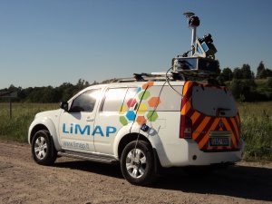
Lithuanian Survey Experts Takes Delivery of SITECO Road-Scanner
Bologna, Italy - SITECO Infomatica SRL has completed the delivery and commissioning of a Road-Scanner-4 to LiMAP, UAB of Vilnius, Lithuania. This latest delivery of the high performance Road-Scanner-4 is the first such configuration in Lithuania and the second…
