
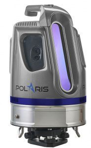
Teledyne Optech is pleased to announce the release of its new Optech Polaris TLS Series of tripod-mounted laser scanners, which bridge the gap between small short-range scanners and heavier long-range scanners. Over three years in development, the Polaris…
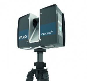
FARO Launches the FocusS Laser Scanner with IP54 Rating and In-Field Compensation for Construction BIM-CIM and Public Safety Forensics Professionals
LAKE MARY, Fla. - FARO® (NASDAQ: FARO), the world's most trusted source for 3D measurement and imaging solutions for factory metrology, product design,…
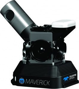
Teledyne Optech Unveils the Ultra-light Maverick for Mobile Asset Mapping
Teledyne Optech is excited to announce the release of its Maverick mobile mapping system. Light enough to be worn on a backpack, the Maverick sets a high…
Trimble Expands 3D Laser Scanning Portfolio with Addition of New TX6 and Improved TX8
HAMBURG, Germany - Trimble (NASDAQ: TRMB) introduced today its new Trimble® TX6 and improved TX8 high-performance 3D laser scanning solutions. With a fully integrated High Dynamic Range (HDR) camera and Wi-Fi remote control, the high-speed 3D laser scanners…
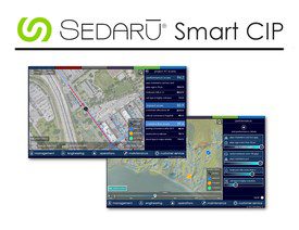
Sedaru Deploys Smart CIP, Advancing the Connected Utility, Empowering Integrated, Dynamic Asset Management for Water/Wastewater Systems
ARCADIA, Calif. - IDModeling, Inc. the leading global provider of smart water software and services, announced today the deployment of Smart CIP™ for integrated, dynamic asset management of water & wastewater systems. Sedaru's Smart CIP technology provides…
TomTom’s HD Map Powers Autonomous Driving
MELBOURNE, Australia - ITS World Congress – TomTom (TOM2) today announces a joint autonomous driving demonstration with Bosch. TomTom provided its HD Map and RoadDNA technology to setup a demonstration on the Australian F1 Grand Prix circuit at Albert Park;…
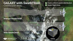
Teledyne Optech Announces New Efficiency Enhancement for ALTM Galaxy Wide-Area Lidar Mapping Sensor
Teledyne Optech is pleased to announce a high-performance scanner update to its innovative line of airborne laser terrain mappers, the Optech Galaxy ALTM™. The Galaxy’s scan efficiency has been engineered to deliver an additional 30% boost to its class-leading…
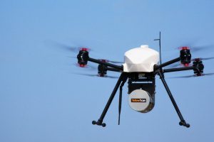
InterGEO2016: AltiGator and YellowScan Unveil a 5.6kg Survey-Grade LiDAR UAV all Integrated System, Ideal for Centimetric Urban Surveys
AltiGator and YellowScan are pleased to announce an ultra-light weight LiDAR UAV combo allowing for the first time centimetric UAV surveys in urban areas, in accordance with most regulations. The YellowScan Surveyor ultra-light stand-alone LiDAR system is…
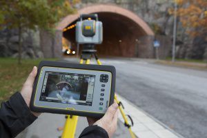
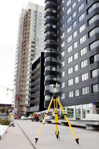
Trimble Unveils SX10 Scanning Total Station for Surveying, Engineering and Geospatial Professionals
SUNNYVALE, Calif., - Trimble (NASDAQ: TRMB) unveiled today a next-generation survey instrument—the Trimble® SX10 Scanning Total Station. It merges high-speed 3D scanning, enhanced Trimble VISION™ imaging technology and high-accuracy total station measurements…
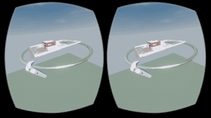
Autodesk LIVE now supports HTC Vive or Oculus Rift
Autodesk brought “on demand” interactivity to the architecture, engineering and construction (AEC) industries when we introduced Autodesk LIVE for Autodesk Revit in July. LIVE is the game-changing, cloud-based service that transforms your Revit model into…
