The First Digital Twin of Earth in 3D, Time-Dynamic and Cloud-Free
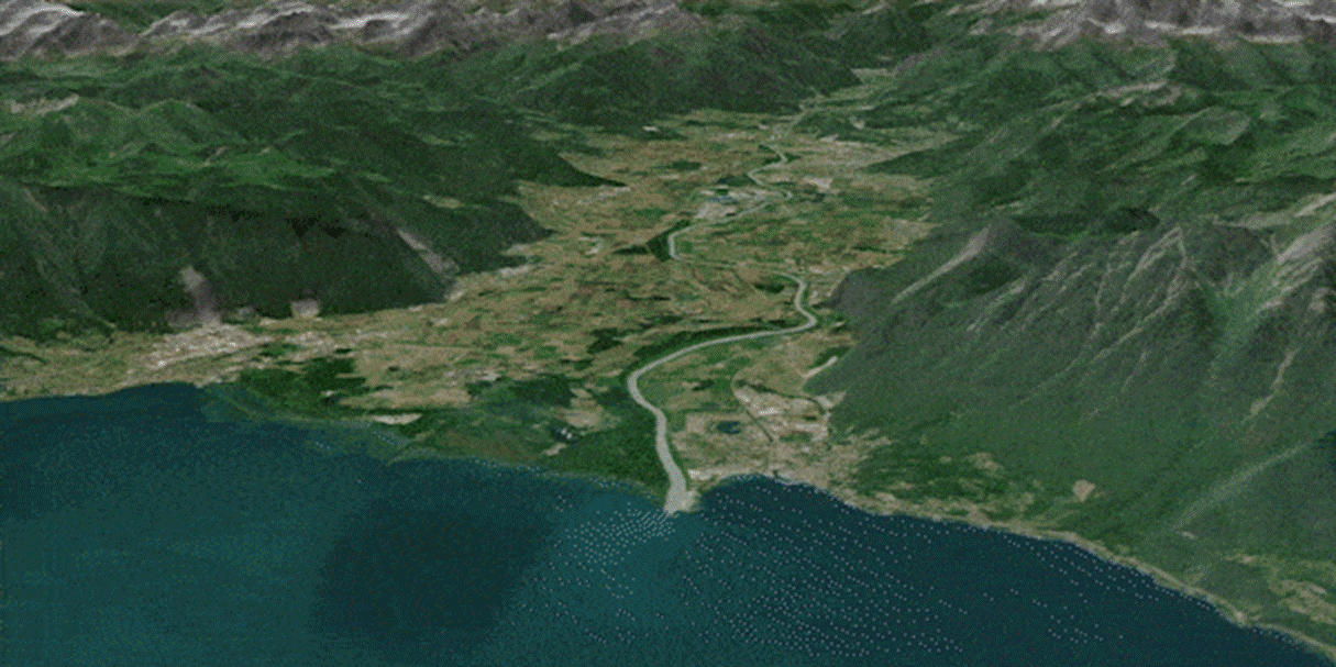
The Rhône valley near Léman Lake, Switzerland - © Nimbo by Kermap
Rennes, January 16, 2024
Nimbo: the clearest, most recent views of our planet
There are various satellite imagery sources out there. But none of them equals Nimbo when it comes to combining resolution, clearness, data diversity and, most of all, update frequency.
Nimbo Earth Online is currently the only platform providing new satellite views of the world at 10-m resolution every month, without clouds, on unrivalled quality images.
All of this in free access, simply by signing up at the following address: maps.nimbo.earth (press access IDs here)
Nimbo's chronological views of the world are 100% developed in-house by Kermap and hosted in Europe. They rely on Sentinel 1 and 2 images supplied by the EU’s Copernicus programme, cloud-cleared and color-harmonized through exclusive deep-learning techniques for image processing (more on the topic)
A French specialist in AI-driven geospatial analysis, Kermap thus reasserts its guiding ambition: making the most of innovative AI techniques and truly facilitate access to Earth observation.
Easy access to satellite data for everyone
Nimbo lets everyone explore the platform's whole chronology of satellite images for free, and in the easiest way possible. So that more people, even not specialized in the field, can give a go at navigating geospatial imagery : students, researchers, journalists, environement or land management professionals, and of course all geography enthusiasts. All Nimbo visualizations are free to share and re-use for non-commercial purposes.
Any kind of user, even without geospatial knowledge, can explore land evolutions on Nimbo's instantly browsable images, displayed in high resolution, thanks to super user-friendly features:
More views from space in Nimbo's Gallery
High-quality world basemaps for GIS professionals
Nimbo's Earth Basemaps clarity and homogeneity make them ideal for geospatial applications based on machine learning: time series analysis, object extraction, change detection... That is why the Nimbo experience also includes access to basemap products designed for geospatial analysis professionals.
Any layer from any month among the nearly 200 basemaps already produced since October 2019 can then be easily retrieved and worked upon.
These products are distributed in standard OGC formats (TMS, WMS), making them compatible with any GIS software. Using the API token available from their Nimbo account, GIS specialists can easily import these basemaps into QGIS (with a dedicated plugin) or ArcGIS for instance, or even feed them into their proprietary geospatial apps.
Leveraging EO and AI to support climate action
As all eyes are on the rapid and unsettling transformations brought about by climate change, space data is one of the most precious resource at our disposal to measure, predict, adapt to and counter these phenomena. Kermap provides the first solution granting universal access to these crucial information, through visualization and analytics extraction. With Nimbo, the invaluable wealth of information contained in space imagery is truly unlocked at last to support today's and tomorrow's climate and environmental actions.
Learn more on https://nimbo.earth
All pictures and animations ©Nimbo by Kermap with Copernicus Sentinel modified data (2023). HD illustrations and press access available here
About Kermap
Rennes, France, based Kermap supplies strategic information extracted from satellite imagery through innovative AI techniques. Its core value: facilitating access to satellite data by bridging the gap between academic research and operationalization for end-users. The company's offering includes on-demand geointelligence and decision support services for local authorities and businesses, but also turnkey, user-friendly thematic land monitoring products through its Nimbo solution. Only six years into existence, Kermap's solutions have already convinced dozens of French players in the fields of land planning, environment and agriculture: French ministry for Agriculture, French ministry for Ecological transition and local authorities (Grand-Est Region, departments of Seine-Saint-Denis and Dordogne, Montpellier Méditerranée Métropole, Rennes Métropole, Limoges Métropole…), public structures (Eau de Paris, Morbihan National Park, French geological survey BRGM...) as well as private customers and partners such as Earthworm Foundation, Nestlé, McCain, Vivescia or Saint Louis Sucre.
More on Kermap at www.kermap.com
Rennes, January 16, 2024
- Nimbo is a free webplatform letting everyone explore evolutive satellite views of the world without clouds, in the clearest format currently available.
- Observing land transformations has never been easier with Nimbo’s 2D/3D views, multiple data layers and user-friendly comparison features.
- The platform developed by French start-up Kermap relies on innovative AI methods to process, clean and homogenize Copernicus 10-m resolution satellite imagery.
- Nimbo also caters to the needs of GIS professionals by providing API access to its monthly basemaps from any GIS software, including a dedicated QGIS plugin.
Nimbo: the clearest, most recent views of our planet
There are various satellite imagery sources out there. But none of them equals Nimbo when it comes to combining resolution, clearness, data diversity and, most of all, update frequency.
Nimbo Earth Online is currently the only platform providing new satellite views of the world at 10-m resolution every month, without clouds, on unrivalled quality images.
All of this in free access, simply by signing up at the following address: maps.nimbo.earth (press access IDs here)
Nimbo's chronological views of the world are 100% developed in-house by Kermap and hosted in Europe. They rely on Sentinel 1 and 2 images supplied by the EU’s Copernicus programme, cloud-cleared and color-harmonized through exclusive deep-learning techniques for image processing (more on the topic)
A French specialist in AI-driven geospatial analysis, Kermap thus reasserts its guiding ambition: making the most of innovative AI techniques and truly facilitate access to Earth observation.
Easy access to satellite data for everyone
Nimbo lets everyone explore the platform's whole chronology of satellite images for free, and in the easiest way possible. So that more people, even not specialized in the field, can give a go at navigating geospatial imagery : students, researchers, journalists, environement or land management professionals, and of course all geography enthusiasts. All Nimbo visualizations are free to share and re-use for non-commercial purposes.
Any kind of user, even without geospatial knowledge, can explore land evolutions on Nimbo's instantly browsable images, displayed in high resolution, thanks to super user-friendly features:
More views from space in Nimbo's Gallery
High-quality world basemaps for GIS professionals
Nimbo's Earth Basemaps clarity and homogeneity make them ideal for geospatial applications based on machine learning: time series analysis, object extraction, change detection... That is why the Nimbo experience also includes access to basemap products designed for geospatial analysis professionals.
Any layer from any month among the nearly 200 basemaps already produced since October 2019 can then be easily retrieved and worked upon.
These products are distributed in standard OGC formats (TMS, WMS), making them compatible with any GIS software. Using the API token available from their Nimbo account, GIS specialists can easily import these basemaps into QGIS (with a dedicated plugin) or ArcGIS for instance, or even feed them into their proprietary geospatial apps.
Leveraging EO and AI to support climate action
As all eyes are on the rapid and unsettling transformations brought about by climate change, space data is one of the most precious resource at our disposal to measure, predict, adapt to and counter these phenomena. Kermap provides the first solution granting universal access to these crucial information, through visualization and analytics extraction. With Nimbo, the invaluable wealth of information contained in space imagery is truly unlocked at last to support today's and tomorrow's climate and environmental actions.
Learn more on https://nimbo.earth
All pictures and animations ©Nimbo by Kermap with Copernicus Sentinel modified data (2023). HD illustrations and press access available here
About Kermap
Rennes, France, based Kermap supplies strategic information extracted from satellite imagery through innovative AI techniques. Its core value: facilitating access to satellite data by bridging the gap between academic research and operationalization for end-users. The company's offering includes on-demand geointelligence and decision support services for local authorities and businesses, but also turnkey, user-friendly thematic land monitoring products through its Nimbo solution. Only six years into existence, Kermap's solutions have already convinced dozens of French players in the fields of land planning, environment and agriculture: French ministry for Agriculture, French ministry for Ecological transition and local authorities (Grand-Est Region, departments of Seine-Saint-Denis and Dordogne, Montpellier Méditerranée Métropole, Rennes Métropole, Limoges Métropole…), public structures (Eau de Paris, Morbihan National Park, French geological survey BRGM...) as well as private customers and partners such as Earthworm Foundation, Nestlé, McCain, Vivescia or Saint Louis Sucre.
More on Kermap at www.kermap.com
Author

Parul Dubey
Video: New Roundabout Under Construction at McIver and Old Florence Roads in Darlington County

K2b Cantonal Highway

June Issue 2026
.jpg?width=225)