
Murphy Geospatial expand services to celebrate 40th anniversary
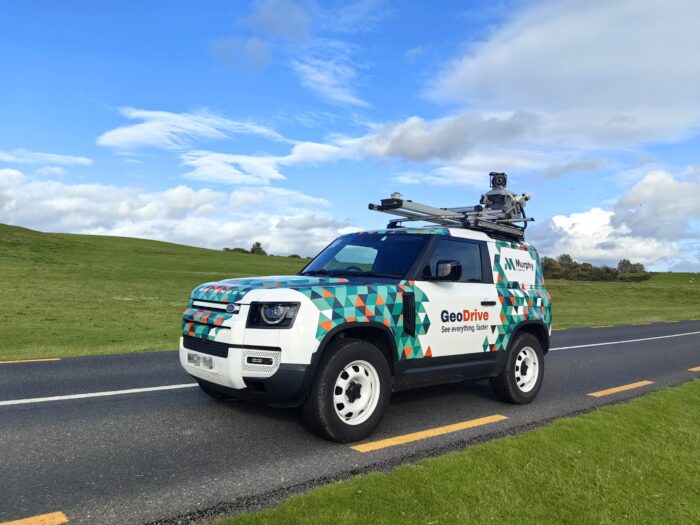
Geospatial leader Murphy Geospatial, is launching a bespoke mobile-mapping technology to support faster and more accurate geospatial data capture in the built environment. The eye-catching vehicle, called GeoDrive, can easily capture up to 100km of geospatial survey data in just one day.
In a world where the sustainability and maintenance of infrastructure assets are of utmost importance, Murphy Geospatial plays a crucial role by providing accurate geospatial data. This data empowers asset owners to make well-informed decisions, ensuring the longevity and efficiency of their infrastructure investments.
The new service, aimed at large projects within construction, infrastructure, and energy and utility sectors, will gather significant volumes of data on large geographical areas at higher speeds and lower cost compared with traditional data capture methods.
How does GeoDrive work?
GeoDrive uses high precision scanners and a multi-camera system to collect sub centimetre accuracy information and is mounted on top of a uniquely branded vehicle or it can be fixed to trains or other moving vehicles. The extremely precise data captured by this new service is also thanks to Murphy Geospatial’s emphasis on quality control of workflows, managed by well-trained staff with their own expertise in geomatics, allowing them to focus on even the most trivial details of a project.
Murphy Geospatial Associate Director Maciej Targosz commented: “This new solution is going to make a huge difference to clients gathering information in relation to large-scale projects. The speed at which GeoDrive can capture data will save clients both time and money when compared with the method of taking a total station along the length of a site.
“GeoDrive also supports cost-effectiveness of projects as it means more-detailed methods of surveying are deployed where they are needed, having already gathered base data for a project’s entirety. This supports informed decision making and optimised resource allocation.
“For clients managing projects that cover highways, it will also eliminate the need for traffic management. GeoDrive will also help clients mitigate project delays, public inquiries, protests, and production bottlenecks.
“We’re looking forward to supporting clients access and analyse the quality data at speed that GeoDrive can gather, and will be offering this new service throughout Ireland, UK, and Europe.”
What can GeoDrive be used for?
- Portal deliverables – provide CAD lines accompanied by a dense point cloud view and panoramic view. This will allow clients to immerse themselves in the street environment and gain a better understanding of the surroundings.
- Point cloud delivery/volume calculations – Utilise Mobile Mapping technology to access areas that are restricted or inaccessible to drones. By collecting under-tree data, the survey can be augmented to provide comprehensive point cloud information. This data can then be used for volume calculations and other relevant analyses.
- GIS asset management – Offers a quick and cost-effective survey solution for roads and railway assets using Geographic Information System (GIS) technology. This will enable efficient management and maintenance of these assets.
- GIS road bridges clearance and haulage mapping – Perform country or county level verification of road bridges on behalf of road authorities in the UK, Ireland, and Europe. This verification process will ensure compliance and safety standards for road infrastructure.
- Multiple surveys – Combine topographical (TOPO) and utility surveys simultaneously using Mobile Mapping (MM) technology in conjunction with RAPTOR (GPR system). This integrated approach provides clients with a quick and discreet survey process, resulting in savings on traffic management.
- Mass data capture – Conduct surveys along road and rail corridors to capture data on vegetation and trees. This information is crucial for identifying potential hazards such as overhanging branches that may impact traffic safety.
- Road condition surveys and feasibility surveys – Offers a defect detection survey to road authorities in the UK, Ireland, and Europe. This survey can be conducted using AI algorithms supporting automatic options, allowing for efficient identification and assessment of road conditions.
- Feasibility surveys – Conducts pre-surveys of road corridors to assess feasibility for future pipeline, cabling projects and wind turbine route planning. This proactive approach enables better planning and decision-making in infrastructure development.
Murphy Geospatial captures, collates, verifies, and governs geospatial data, enabling clients to make informed decisions across the project lifecycle. Founded in 1983, it now employs over 350 industry experts and has completed over 27,000 projects to date including Dunkettle Interchange, HS2, Liverpool City Centre Connectivity Scheme and more.
For more information on GeoDrive, visit murphygs.com/geodrive/ or contact John Richardson on +353 86 776 6639
Media contact
Rachel Hodgson | [email protected] | 07581099134 | +44191 2325690
About Murphy Geospatial
Murphy Geospatial captures, collates, verifies and governs geospatial data, enabling its clients to make informed decisions across the project lifecycle.
Murphy Geospatial delivers proven geospatial solutions through the design, construction and in-use phases of projects across six key sectors; Construction, Utilities, Infrastructure, Manufacturing, Property and Natural Environment.
Services include Geospatial Consultancy, Aerial / UAV Surveys, BIM, Digital Construction, Topographical Surveys, Laser Scanning, Property Surveys, Rail Surveys, Structural & Environmental Monitoring, Subsurface Investigation and more.
Founded in 1983, Murphy Geospatial’s highly developed workflows have been refined through the delivery of over 27,000 projects over 40 years. The organisation now employs over 350 people in its six offices across Ireland and the UK.
