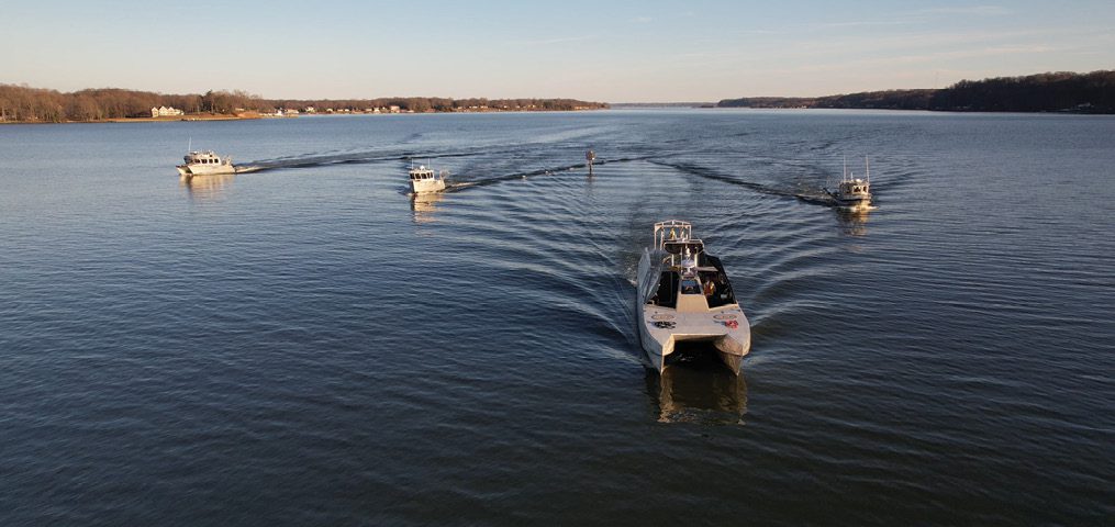
Woolpert mobilized five hydrographic survey vessels (nearly a quarter of its fleet) equipped with multibeam and side-scan sonar systems for the Chesapeake Bay project that focused on 615 square nautical miles, some of which had not been surveyed for more than 50 years. (Image credit: Woolpert)
The full video interview of Woolpert Chief Operating Officer Kirk McClurkin can be viewed at bit.ly/41lmajS.
The way we define our firm is AEG: architecture, engineering and geospatial,” explains Woolpert Chief Operating Officer Kirk McClurkin. “From an outside perspective, you might think that’s our three pillars, right? But for us, almost everything we do in infrastructure has a geospatial component, and we like to lead with that.”
Founded in 1911, Woolpert lays claim to 112 years of geospatial experience, more than 800 geospatial professionals on staff, more than 1,000 completed international mapping projects and more than 1 million square kilometers of geospatial data collected annually.
“Woolpert has always been early adopters of geospatial technology,” adds McClurkin. “In the 1950s, we were flying planes, doing imagery, planimetrics, etc. And we learned to use that data for architectural planning, design and engineering, and we just kept going. Geospatial is the biggest part of Woolpert’s DNA.”

When it comes to gathering and analyzing data with a geographic location on, above or below Earth’s surface, a case can be made that Woolpert’s depth and breadth of expertise and collection of cutting-edge technology make it the most accomplished and successful “geospatial first” consulting firm in the world. Woolpert speaks of itself more modestly, but it’s obvious the firm is proud of what it accomplished by focusing on geospatial as an important sector—not just an unglamorous necessity in service to architecture and engineering.
According to McClurkin, two factors contributed to this achievement:
“First, Woolpert’s always had a mission to be cutting edge when it comes to technology,” he notes. “We’re over 110 years old, we’ve been doing geospatial-type work since the beginning, and we’ve built a culture that flourishes on the best way to use the different technologies. And we contribute ‘grassroots improvements’ to geospatial technology from our experts working on projects.
“And second, we’ve developed, in this century, a comprehensive planning process that really looks at our current technologies, new or emerging technologies, and how that works with our overall technology stack. When we’re interested in something new, we have a detailed process to build a business plan around it so we can track the progress, have some milestones and really understand the return on investment.”
That planning process, which is basically a methodology for rapidly onboarding more of the best new geospatial technology, sparked an inflection point in Woolpert’s growth.
“Probably around 2015, 2016 was when we started that,” explains McClurkin. “There wasn’t a particular investment, but a lot of investments every year based on our specific markets and what’s happening in the technology world. Deliberate, planned investment kicked off then. At that time, we had about 800 employees in 25 offices. Today, we have a little over 2,000 employees and 62 offices. Our sales this year will exceed a half a billion dollars, $300-plus million in revenue—a tremendous amount of growth over the last six, seven years.”
More Than Surveying
One way to appreciate Woolpert’s rapid growth is to look at the size and variety of recent projects.
• Working for the U.S. Navy, Woolpert (as partner in NAVGeo LLC, a joint venture) collected airborne lidar and imagery services for the production and delivery of digital elevation modeling, orthoimagery and planimetric feature extraction over Sembawang Naval Base in Singapore. This required creating a new, highly accurate 3D control network. The team captured airborne lidar at a nominal pulse spacing of 0.28 meters (12 ppsm) simultaneously with the aerial imagery over the 4.8-square-mile project site. Deliverables included high-resolution digital orthophotos captured at 6 centimeters GSD to produce 7.5-centimeter-pixel-resolution natural-color (RGB) imagery products.
The city of Palm Coast, Fla., tapped Woolpert to create a citywide monitoring strategy to identify and compile information influential in developing and directing the city’s stormwater monitoring program. This strategy included a phased augmentation of the city’s network to include water quality at the 12 real-time monitoring stations used for automated flood control within the community’s many canals and to assist with proactive storm response and traffic-routing capabilities.
• In March 2023, the National Oceanic and Atmospheric Association contracted with Woolpert to perform hydrographic surveying and collect bathymetric data for hydrodynamic modeling over 615 square nautical miles of the Chesapeake Bay Watershed, including portions of the Potomac, Rappahannock, James and York rivers, which in some areas have not been surveyed for more than 50 years. To do this work, five hydrographic survey vessels will be mobilized (a quarter of Woolpert’s fleet), all equipped with multibeam and side-scan sonar systems. According to Woolpert Program Director and Certified Hydrographer Dave Neff, “This is an outstanding use of taxpayer dollars, because it is all about improving public safety, advancing the blue economy and preserving the environment for decades to come.”
• Woolpert was contracted by the U.S. Army Corps of Engineers and Pro-ROV Services for the Browns Valley Irrigation District under separate contracts to collect and integrate lidar and multibeam sonar data. The data were used to map and model Collins Lake, a reservoir located northeast of Sacramento, Calif., in the foothills of the Sierra Nevada Mountains, and for capacity surveys conducted at Lake Isabella east of Bakersfield, Calif. “With the ongoing drought, the accuracy of these data is essential to the effective management of water resources,” says Neff. “Collecting and integrating lidar and multibeam sonar data ties together two technologies and creates a precise and seamless elevation model. That model is then hosted within a point cloud for state and local officials to access, so they can effectively plan and manage these critical assets.” UAVs and fixed-wing aircraft were used to collect lidar data, and sonar data was collected by eTrac, a Woolpert Company, which is a vessel-based hydrographic survey firm acquired by Woolpert in February 2022. “We are fortunate to have the staff and equipment to collect data as each project demands,” adds Neff. “With three offices in California, we understand all too well the impact the drought has on the state. Advanced technologies such as these hold the key to the state’s ability to overcome the water crisis. We are here and ready to help.”

Woolpert was contracted by the U.S. Army Corps of Engineers Engineering Research and Development Center (ERDC) to incorporate advanced sensors into the concrete runway pavement as it was being constructed, which enabled ERDC to monitor the pavement response and damage accumulation through time with critical military aircraft systems. By incorporating these new material and sensor technologies into a “SMART Runway” project, the Department of Defense will validate new cost-saving pavement designs, develop a better understanding of how modern aircraft produce incremental damage in the pavement, and validate new pavement “health monitoring” sensors that will provide airfield owners with critical information on the condition of this vital DOD infrastructure asset. A total of 228 sensors were installed in the subgrade and pavement layers along the length of a newly constructed runway at a western region air force base. Woolpert also built a web portal that tied in data from all 228 sensors in real-time and coupled to an Internet of Things (IoT) application to support a five-year runway-monitoring program.
Mitigating Risk and Preserving Culture
Rapid growth achieved largely by extraordinary commitment to cutting-edge technology is an exhilarating and risky path. How does Woolpert mitigate the financial risk of technology investment and preserve a century-old corporate culture while onboarding companies and new methods?

“It’s a big challenge,” McClurkin says plainly. “Regarding risk, I would say maybe we don’t mitigate it as much as we try to manage it, because there’s risk in everything. We believe in our staff, and what they believe will change and morph us around the technology. The main thing we do is strong planning; we really plan out what we want to do and what those successes will look like. And then we keep on it as far as monitoring and controlling. We’ve learned that sometimes we have to stop—it’s not working. Other times, it might cost more, but we just keep going and manage it better. We do limit the amount of new things we do—we don’t want too many things to do every year.”

Woolpert consciously supports researching and testing new technology, and it keeps abreast of the small firms leading geospatial innovation. “For example, we have our own dedicated AI and machine-learning team, and they’re completely focused on what they can do around innovation in that sector,” notes McClurkin. “We have a lot of verticals we’re focused on. There’s a ton of pilot testing on everything, because we’re always evolving what we’re doing—our workflows. We have groups of subject-matter experts. And every year, when we go through our planning process, they assess the current technologies we have—what’s working, what’s not working, where we need improvements, where technology might be evolving or emerging. This can come from any product or could also come from our business partners who provide beta products to test.”
Culture would seem to be a nebulous concept, not subject to the rigorous analysis that’s applied to new technology, but Woolpert doesn’t see it that way. “When you have that much growth, you’re trying to sustain your culture, but also embrace the culture of everybody you’re adding. And it just grows more so over time,” says McClurkin. “We have a defined set of core values, and those core values are focused on our people and our culture. Every month we talk about how our culture is developing and if we’re doing the right things.
“We have a long-term vision to be one of the world’s best companies,” he adds. “We might not be the biggest. We might not have the most people. But we want to be one of the best.”

Angus Stocking
Angus Stocking is a former licensed land surveyor who has been writing about infrastructure since 2002 and is the producer and host of “Everything is Somewhere,” a podcast covering geospatial topics. Articles have appeared in most major industry trade journals, including CE News, The American Surveyor, Public Works, Roads & Bridges, US Water News, and several dozen more.
Video: New Roundabout Under Construction at McIver and Old Florence Roads in Darlington County

Bridge Replacement at Amsterdam Centraal Station

June Issue 2026
.jpg?width=225)