

Micro-scholarships aim to help larger number of Black and mixed Black heritage students Esri UK today announced it has partnered with Akama Fund, a charity dedicated to supporting students and facilitating accessible scholarships, to create a new scholarship…
Now Available: Trimble Business Center Version 5.90
Released on May 30, 2023, Trimble® Business Center (TBC) version 5.90 software further advances capabilities targeted specifically at integrated…
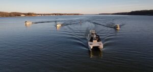
Woolpert Puts the ‘G’ in AEC
Woolpert mobilized five hydrographic survey vessels (nearly a quarter of its fleet) equipped with multibeam and side-scan sonar systems for the Chesapeake…

New Trimble GEDO GX50 Laser Scanning System Introduced for Clearance Analysis and Asset Data Collection for Railway Applications
Innovative and Flexible Laser Scanning Solution Designed to Assist Railway Track Surveying Professionals SUNNYVALE, Calif. — Trimble (NASDAQ: TRMB) introduced today the Trimble® GEDO GX50, a flexible laser scanning system designed to operate with Trimble…

Woolpert Welcomes Aviation, Geospatial Specialist Dejan Damjanovic as Project Manager
The licensed commercial pilot and GIS expert will help expand the firm’s NextGen and AAM offerings. DENVER (June 22, 2021) — Woolpert has hired aviation and geospatial visionary Dejan Damjanovic as an aviation geospatial project manager. Damjanovic has…

Woolpert Welcomes Ryan Thomas as Program Director for Energy Market
Thomas has an extensive background in the power and utilities industries, with a focus on renewable energy. BIRMINGHAM, Ala. — Woolpert has hired Ryan Thomas as a program director for the firm’s energy market. Thomas is a chemical engineer who brings 20…
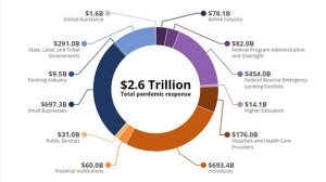
Woolpert, Smartronix Tracking COVID-19 Relief Funding for the Council of the Inspectors General on Integrity and Efficiency
A team of geospatial experts are building datasets and a mapping application to provide information management and transparency in support of the Pandemic Response Accountability Committee and its public website. WASHINGTON, D.C. — Woolpert has been…
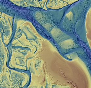
Quantum Spatial Completes Data Collection for NOAA’s Largest Coastal Mapping Project
Unique Combination of Sensors Used to Gather High Resolution Topographic and Bathymetric Lidar Data Along 12,000 Square Miles of Eastern Seaboard and Gulf Coast Areas Not Surveyed Since Civil War Era HOLLYWOOD, Fla.– Quantum Spatial, Inc., an…
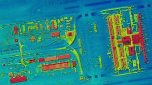
First high-resolution, homogeneous Digital Surface Model (DSM) for Germany
DSM of Munich Airport – With the HxGN Content Program, Hexagon now provides the first up-to-date, homogeneous and high-resolution Digital Surface Model (DSM) of Germany.(above image) HxGN Content Program delivers airborne DSM to the Federal Agency…

Dewberry’s Deborah Mills Named ASFPM Foundation Fellow
The Association of State Floodplain Managers (ASFPM) announced that Deborah Mills, CFM, has been named a Foundation Fellow. The ASFPM Foundation began its Fellows Program to provide an opportunity for long-standing supporters to remain engaged and active in…
