

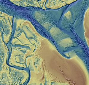
Woolpert mobilized five hydrographic survey vessels (nearly a quarter of its fleet) equipped with multibeam and side-scan sonar systems for the Chesapeake Bay project that focused on 615 square nautical miles, some of which had not been surveyed for more than…

NOAA Selects Woolpert for Hydrographic Survey, Bathymetric Data Collection in Chesapeake Bay Watershed
THESE DATA WILL SERVE SEVERAL MISSIONS IN YEARS TO COME, INCLUDING NAVIGATION, INUNDATION MODELING, FLOODPLAIN ANALYSIS, AND COASTAL RESILIENCE. …

New agreement puts NOAA, ASCE on the road to climate-ready infrastructure
When Hurricane Florence crossed the North Carolina, coast on September 14, 2018, it brought hurricane-force winds and — as forecasted — strong storm…

NOAA, University of Maryland, ASCE to Advance Climate-Smart Construction
RESTON, Va. — The NOAA Climate Program Office has forged a partnership with the University of Maryland (UMD) Center for Technology and Systems Management and the American Society of Civil Engineers (ASCE) to accelerate the development of climate-smart engineering…
Quantum Spatial Completes Data Collection for NOAA’s Largest Coastal Mapping Project
Unique Combination of Sensors Used to Gather High Resolution Topographic and Bathymetric Lidar Data Along 12,000 Square Miles of Eastern Seaboard and Gulf Coast Areas Not Surveyed Since Civil War Era HOLLYWOOD, Fla.– Quantum Spatial, Inc., an…

Dewberry Will Support $844,000 Grant from the National Oceanic and Atmospheric Administration
The National Oceanic and Atmospheric Administration's (NOAA) Office for Coastal Management recently awarded the City of Virginia Beach an $844,000 grant to assist the city with sea level rise (SLR) planning. Part of NOAA's Regional Coastal Resilience Grant…

NOAA Awards Tetra Tech $49 Million Coastal Geospatial Contract
PASADENA, Calif -Tetra Tech, Inc. (NASDAQ: TTEK) announced today that the National Oceanic and Atmospheric Administration (NOAA) has awarded the Company a $49 million, indefinite delivery, indefinite quantity contract to support the Office for Coastal Management’s…
Esri Maps NOAA’s National Water Model
New Real-Time Maps Transform Forecast Data into Vivid Pictures of U.S. River Flows REDLANDS, Calif.—August 25, 2016—Smart-mapping leader Esri today released a beautiful, robust new collection of Web maps that forecast NOAA stream-flow data throughout…
