Sponsored by:

By Marc Goldman
We live, work and play in a world we have created and manipulated to meet our needs. We’ve built houses, offices, hospitals, parks, roads, waterways and hundreds of other structures that allow us to do what we do. However, as the population is growing and the world becomes more connected and complex, our ability to respond to the challenges of the future requires us to reexamine how we plan, design, build and operate our world.
We cannot continue using the same old methods to solve new problems that are ever growing in complexity. The planners, architects, engineers, builders and operators of our built world need tools that will enable them to solve these complex problems. They need location intelligence.
Location Intelligence—Obtaining Meaningful Insight from Spatial Data
Location intelligence applied to a wide range of architecture, engineering and construction (AEC) projects expedites deliverables and leads to better decision-making. Architects, engineers, builders and owners improve their workflows, bring context to their projects and increase collaboration through the use of location intelligence. The entire project lifecycle is affected, improving the way you Plan, Design, Build and Operate projects. Efficiencies are discovered, insights are gained, and engagement across the project team grows.
Plan
The purpose of the plan phase in AEC projects is to understand the existing conditions, make projections and set up the project to meet the needs of the stakeholders in the most efficient, compliant and well-thought-out manner. While other visualization and data management tools exist to address these requirements, deep scientific analytics using location intelligence can only be delivered through geographic information system (GIS) technology.
GIS solutions connect and manage geographic content that is critical in making AEC project planning decisions. GIS organizes content into data layers including the following:
• Property lines, offsets, driveways and easements
• Existing/proposed conditions
• Building permits
• Aerial and reality captured data
• Surveys, fixtures and utilities
GIS technology brings critical insights to the surface, delivered in project studies, reports and analyses. In addition to the visual analytics from overlaying layers of data, GIS provides thousands of analytical tools unmatched by any other system. Access to this information during this phase means AEC teams start off fully informed and empowered to produce a great project based on data-driven and location-based insights.
Design
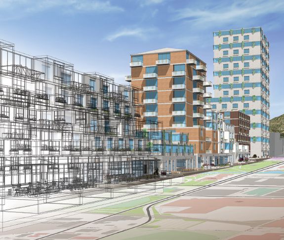
During the design phase, teams work to develop conceptual, schematic and detailed project views that strive to address issues of form, function and viability. Architects, landscape designers, urban planners and engineers use GIS as one of their key business systems during this problem-solving process. Adding geographic context to their drawings, schematics and models enriches the data, and efficiencies are realized. Combining building information modeling (BIM) and CAD data with reality captured imagery, 3D meshes and every type of map imaginable brings new visualizations to the processes in the design phase.
Providing design-phase teams with access to both aboveground and belowground location intelligence enables them to detect and avoid conflicts between sites and proposed built structures. Projects are better engineered and coordinated by combining models with GIS and traditional AEC content.
Location intelligence allows architects and engineers to design the places where we live, work and play.
Build
Managers, superintendents and fieldworkers combine efforts during the build phase to prepare detailed plans and then execute against those plans in predictable, safe and cost-conscious ways. Location intelligence applied to the build phase brings visibility to the best use of people, materials, equipment and supplies coming and going from the jobsite daily. Understanding the volume, velocity and schedule of materials onsite brings a valuable understanding of a project’s supply chain and logistics challenges.
GIS offers a common view (from real-time visuals to historical context) of essential information to the team, whether in the office or on the jobsite. Team members can now use familiar maps populated with workflow, personnel and asset data to connect, orient and inform users.
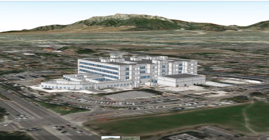
As the physical work is completed, having been measured and tracked through a GIS-based solution, the project’s digital handover is based on the project’s digital twin. A digital twin is a combination of the models, the drawings and all the relevant information, completely describing and mirroring a building digitally. Digital twins are synchronized with the physical building they represent. The engineering specifications, construction errors and measured performance data create a complete digital representation to support the lifecycle of the building. GIS is the ideal platform to create, manage and handover a digital twin.
Operate
Proper management and maintenance during the operate phase ensure the project fulfills its mission during its lifespan. GIS technology provides visualization for managing, maintaining, monitoring and ongoing lifecycle reporting. GIS plays a pivotal role in this phase for organizations managing infrastructure or building projects. Sharing information with internal and external stakeholders provides them with analytical tools to support critical business decision-making and scheduling.
During the operate phase, owners and operators can leverage a GIS platform to conduct strategic-level portfolio planning, detailed space planning, and move management tasks. They also can use GIS solutions to perform building-condition assessments, fire-safety inspections and asset inventories in relation to route mapping and various compliance reporting.
A GIS platform allows users to view, analyze and take action on information inside and outside of buildings in one seamless environment. Solutions that utilize location intelligence revolutionize the way operations, maintenance and facilities management accomplish phase tasks.
GIS and BIM: Driving Toward Fully Digitalized Workflows
By Chris Andrews, Esri
In the 1980s and 1990s, CAD and GIS emerged as competitors—two graphical solutions vying for professionals working with spatial data. In that era, the sophistication of software and capacity of hardware limited what could be done with computer-assisted technology. CAD and GIS appeared to be overlapping versions of computerized tools for working with geometry and data to produce paper documentation.
Whereas CAD systems initially focused on automating drafting tasks, building information modeling (BIM) has pushed away from drawing creation toward creating intelligent digital models of real-world assets. The highly sophisticated models created with modern BIM processes during design can now simulate construction to eliminate potential design defects and mitigate risk. The models are used to generate highly accurate simulations of schedule and budget compliance during the build phase with dynamically changing schedules.
GIS has also evolved, having even greater capability. GIS can handle billions of events from live building sensors and serve visualizations of petabytes of 3D project data from a variety of reality capture methods. Users can explore interactive 2D and 3D visual environments from a browser or mobile device powered by complex predictive analyses performed in the cloud. Maps once printed out as paper analytical tools have been transformed into dashboards for synthesizing complex AEC analysis delivered in familiar and human-interpretable form.
To realize the full potential of integrated workflows between BIM and GIS, Esri brings these worlds together. Domains such as smart cities, digitized engineering and digital twins delivery benefit from this integration.
What were once competing technologies supporting centuries-old paper processes have propelled the construction industry toward digital workflows improving how we plan, design, build and operate the built world.
Download the GIS and BIM Integration: Common Myths and Practical Outcomes white paper from go.esri.com/aec-bim-wp.

Marc Goldman
Marc Goldman is director, AEC Industry Solutions, Esri.
Video: New Roundabout Under Construction at McIver and Old Florence Roads in Darlington County

Bridge Replacement at Amsterdam Centraal Station

June Issue 2026
.jpg?width=225)