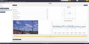
Trimble 4D Control Software Provides Greater Geotechnical Sensor Support
STUTTGART, Germany, Sept. 17, 2019—Trimble (NASDAQ: TRMB) announced today an update to its core real-time monitoring software—Trimble® 4D Control. Building on the recently released version 5.0, this update delivers support for Senceive’s wireless monitoring systems, streamlining the configuration process for users and delivering real-time data from geotechnical sensors to one common platform. By receiving data through Senceive’s wireless gateways into Trimble 4D Control software, project stakeho...
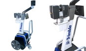
Trimble Enhances its Indoor Mobile Mapping Solution with New Software for Improved Workflow and Results
STUTTGART, Germany, Sept. 17, 2019—Trimble (NASDAQ: TRMB) introduced today two new software releases designed to further simplify and improve the workflow for indoor mobile mapping, while also improving the final map products that the Trimble® Indoor Mobile Mapping Solution (TIMMS) produces. The announcement was made today at INTERGEO 2019, the world’s largest conference on geodesy, geoinformatics and land management. TIMMS is the optimal fusion of technologies for capturing spatial da...
Teledyne Optech Introduces OEM TLS-M3 for Marine, Monitoring and Mobile Applications
VAUGHAN, Canada — September 17, 2019 — Teledyne Optech, a Teledyne Technologies [NYE:TDY] company and global leader in advanced lidar sensors, will showcase its new high-resolution, long range scanner, the TLS-M3 at InterGEO this week. The new scanner boasts powerful features including a protective encasement for marine environments, integrated inclinometer, and compass with external camera support. With the capacity to operate at up to three speeds, the TLS-M3 has ranges of 250m up to 2000m...
Applanix Releases New POSPac LiDAR Quality Control Tools for UAVs
Stuttgart, Germany, September 17, 2019 - Applanix, a Trimble Company (NASDAQ: TRMB), introduced today LiDAR Quality Control (LiDAR QC) Tools for Unmanned Aerial Vehicles (UAVs)—a new software module supported by the latest release of Applanix’ industry-leading GNSS-aided inertial post-processing software packages, POSPac Mobile Mapping Solution (MMS) and POSPac Unmanned Aerial Vehicles (UAV). LiDAR QC Tools for UAVs are specifically designed to achieve higher accuracy LiDAR point clouds from a U...
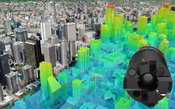
Leica Geosystems Announces Major Efficiency Improvement to Airborne Urban Mapping Solution
HEERBRUGG, Switzerland, 17 September 2019 – Leica Geosystems, part of Hexagon, introduces the Leica CityMapper-2. This next generation hybrid oblique imaging and LiDAR sensor provides fast and efficient digitisation of cities. As part of Leica Geosystems’ RealCity solution, which combines the CityMapper-2 with the Leica HxMap high-performance processing workflow, the new sensor is designed to provide faster updates while preserving image quality over a wide range of flying conditions. The...
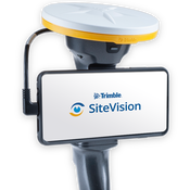
Trimble's New High-Accuracy Handheld Augmented Reality System Takes Data Visualization Outdoors
SUNNYVALE, Calif. - Trimble (NASDAQ: TRMB) introduced today its Trimble® SiteVision™ system, an outdoor augmented reality (AR) solution that enables users to visualize 2D and 3D data on virtually any project site with cellular or internet connectivity for easier and more efficient planning, collaboration and reporting. Combining hardware and software in an integrated, lightweight handheld or pole-mounted solution, users can view 3D models and assets in a real-world environment at a 1:1 scale, fr...
Teledyne Optech introduces its latest Airborne Laser Terrain Mapper for Wide Area and Corridor Surveying
New Galaxy T2000 dual-mount lidar system enables unmatched collection efficiency and point density VAUGHAN, Canada — September 17, 2019 — Teledyne Optech, a Teledyne Technologies [NYSE:TDY] company, and global leader in lidar sensing is pleased to announce the next evolution of its award-winning Galaxy™ platform, the Galaxy T2000. A compact lidar-mapping sensor, the Galaxy T2000 provides a unique feature set for maximum collection efficiency and point density, and is the next step in the evo...
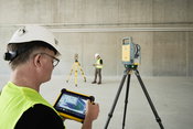
Trimble Blends Performance and Simplicity with New X7 3D Laser Scanning System
Innovative High-Speed 3D Laser Scanning System Simplifies Use, Increases Efficiency and Provides Confidence in the Field to Capture Digital Data SUNNYVALE, Calif.— Trimble (NASDAQ: TRMB) introduced today the Trimble® X7 3D laser scanning system, enabling professionals of all scanning levels to quickly and easily capture precise 3D scanning data to produce high-quality deliverables. Ideal for surveying, construction, industrial and forensic applications, the Trimble X7 3D laser scanne...
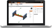
New IDEA StatiCa Version 10.1 is Live
We are happy to announce the brand-new version of IDEA StatiCa 10.1 release. This version brings an exceptional volume of new features and improvements with the focus to enable engineers to work faster, evaluate the requirements of the national code thoroughly and use the optimal amount of material. It does not matter if you focus on steel or concrete structures or if your main goal is a quick and flexible workflow, we have plenty of new enhancements for everybody. The best way to start is...

AECOM to Launch PFAS Solution DE-FLUORO™ at CleanUp 2019 in Adelaide
ADELAIDE — AECOM, a premier, fully integrated global infrastructure firm, announces the launch of DE-FLUORO™, a technology that effectively and permanently removes per- and poly-fluoroalkyl substances (known as ‘PFAS’) at CleanUp 2019. CleanUp, the eighth International Contaminated Site Remediation Conference, will be hosted September 8-12 by CRC CARE in Adelaide. Given the growing demand for an effective way to permanently remove PFAS, a number of AECOM technical specialists will present findin...
Video: Crashes Drop Measurably After Rural Road Safety Improvement Project on US 521 in Lancaster County

AdventHealth Weaverville Hospital

June Issue 2026
.jpg?width=225)