Teledyne Optech Announces the CL-360, a Compact, Long-range, Survey-Grade Lidar Sensor for UAV and Mobile Applications
VAUGHAN, Canada — Teledyne Optech, a Teledyne Technologies [NYSE:TDY] company and global leader in advanced lidar sensors, is pleased to announce the CL-360, the next offering in its new line of compact lidar sensors for UAV and mobile applications. The CL-360 boasts survey-grade data precision that is synonymous with Teledyne Optech lidar sensors and is designed specifically to meet the needs of OEM hardware manufacturers to develop products for mobile, static, UAV or airborne surveying markets...

VPG Transducers Launches New Silo Weighing System
MALVERN, Pa. — September 12, 2019— The VPG Transducers brand of Vishay Precision Group, Inc. (NYSE: VPG), global designers and manufacturers of standard and custom force, pressure, torque, load, tension and weight sensors, today announced the introduction of its S Series Silo Weighing System. The S Series offers a cost effective solution to accurately measure the weight of a silo while providing the option for temperature measurement. Users can utilize these measurements (weight and temperature)...
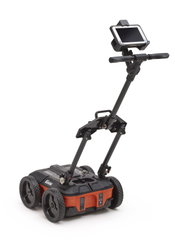
GSSI to Showcase at the 37th INTERNATIONAL NO-DIG Conference & Exhibition
GSSI, the world’s leading manufacturer of ground penetrating radar (GPR) equipment, will showcase its UtilityScan and StructureScan Mini XT at the 37th INTERNATIONAL NO-DIG Conference & Exhibition, which will be held September 30-October 2, 2019 in Florence, Italy, Booth 56. Visitors to the booth can also see the UtilityScan system, a compact GPR unit that is extremely portable and easy to maneuver in tight survey areas. This model sets a new standard in performance and price. UtilityScan fea...

Select and Download Sections of Large Point Clouds Right in Your Browser with NavVis IndoorViewer 2.5
The upcoming release of NavVis IndoorViewer 3D building visualization software will include a new feature to select, crop and download point cloud sections in browser. The beta version of the extended point cloud functionality in NavVis IndoorViewer will be previewed at INTERGEO 2019. Munich, Germany – NavVis, the leading global provider of indoor spatial intelligence technology and enterprise solutions, announces the beta release of NavVis IndoorViewer 2.5. This major software relea...
Vectorworks, Inc. Announces 2020 Version of BIM and Design Software
Experience a smoother workflow with improvements to the VGM level of detail. Columbia, MD — Global design and BIM software provider Vectorworks, Inc. announces the 2020 release of Vectorworks Architect, Landmark, Spotlight, Designer and Fundamentals, as well as 2020 versions of Vision and Braceworks. This newest release brings improved software performance, quality enhancements and new data-driven workflows. “Data and usability are the cornerstones of this year’s product line enhancem...

The Wild and Igloo Vision Partner to Bring Real-Time VR/AR Collaboration to Immersive Shared VR Environments
The Wild and Igloo Vision partner to bring real-time VR/AR collaboration to immersive shared VR environments Portland, OR & Shropshire, UK – 10, September 2019 – Today, Igloo Vision and VR/AR collaboration platform The Wild announced their integration, which will open up even greater possibilities for collaboration and experiential design review for teams working in architecture, engineering, and construction (AEC). Igloo Vision designs and develops immersive 360° projection spaces, along...

Road-SIT Survey v. 7.5: The Features that Streamline the Survey Work
10 September, 2019, Bologna Italy – SITECO Infomatica SRL will be attending Intergeo 2019 in Stuttgart, Hall 3, Stand B3.025, showcasing the Road-Scanner family of Mobile Mapping Systems and the NEW software release of Road-SIT Survey. Road-SIT Survey is the mobile mapping data application developed by Siteco, fully compatible with the most widespread mobile mapping systems like the Optech-Lynx, Riegl-VMX, Topcon IPS3 and Leica Pegasus. And of course with the well-known Siteco’s Road-Scanner....

Flexible, Adaptable, Strong, Easy to Work With, ACH Foam Technologies’ Molded Polystyrene Foam Is Unlike Anything Else
WESTMINSTER, Colo., Sept. 10, 2019 - It isn’t like any other material - extremely strong yet incredibly lightweight; large but easily moved; durable yet capable of being finely articulated down to the smallest crevice. Molded polystyrene foam from ACH Foam Technologies is being used by sculptors at PLAYTIME to create immersive, animated playscapes and climbable characters. “We use artistry to create truly believable fairytale environments,” says Spencer Smith, a talented sculptor who spends h...

Trimble Announces New Offline Data Transfer and Post-Processing Workflow for Trimble TerraFlex Software
SUNNYVALE, Calif.— Trimble (NASDAQ: TRMB) announced today its Trimble® TerraFlex™ field software now supports the transfer of data between the field and office without the use of Trimble cloud services. The new software workflow—called offline data transfer—is possible through the integration of Trimble TerraFlex and the Trimble Positions™ Desktop add-in for Esri® ArcGIS® Desktop. TerraFlex is a field solution that enables mobile workers to easily collect, manage and edit their geospatial featur...
New Integration for Autodesk Civil 3D
Our partnership with Esri continues to develop, enabling more streamlined flow of data between design tools and GIS. Now, the integration of BIM and GIS has come to Civil 3D! Autodesk® Civil 3D® continues to deliver improvements to design, performance and collaboration efficiencies, enhancing BIM design workflows for larger, more complex infrastructure projects. However, with this latest release – Civil 3D 2020.1 – we are extremely excited to introduce the Autodesk Connector for ArcGIS...
Video: Crashes Drop Measurably After Rural Road Safety Improvement Project on US 521 in Lancaster County

AdventHealth Weaverville Hospital

June Issue 2026
.jpg?width=225)