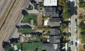
HxGN Content Program Now Offers High-definition Aerial Data in the United States
HxGN Content Program now offers high-definition aerial data in the United States WASHINTON, D.C., USA (24 September 2019) — Hexagon’s Geosystems division announced today the HxGN Content Program, the largest library of on-demand aerial imagery after five years of continuous aerial data collection across the United States, offers a new high-definition orthophoto layer of 15-centimetre- wide area and 5-cm urban area coverage. The program moves from 30 cm to 15 cm resolution across the c...
Ground Penetrating Radar: The Unlikely New Hero of Autonomous Vehicles
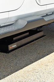
GSSI, the world’s leading manufacturer of ground penetrating radar (GPR) equipment, announces TerraVision™, the first-to-market localizing ground penetrating radar (LGPR) technology that improves navigation for autonomous vehicles (AVs). The LGPR technology was originally developed at MIT Lincoln Laboratory for military applications and is designed to help navigate even in the worst driving conditions on the planet. It works by sending radio waves into the ground, creating a digital fingerpri...

Skanska USA Conceives Solution for Calculating Embodied Carbon in Construction Materials, Announces Transition to Open-Source Tool
New York - Skanska USA, alongside the Carbon Leadership Forum and partners in industry, today announced the creation of the Embodied Carbon in Construction Calculator (“EC3”) tool, a ground-breaking solution for calculating and evaluating the carbon emissions embodied within a wide array of building materials. The EC3 tool, which was initially conceived by Skanska and developed with C Change Labs, was jointly seed-funded by Skanska and Microsoft—who determined that a collaborative, open-source s...
Trimble Announces New Release of Advanced Wastewater Monitoring and Analytics Software for Municipalities and Utilities
CHICAGO - Trimble (NASDAQ: TRMB) introduced today the latest version of its Trimble Unity™ Remote Monitoring software for water, wastewater and stormwater utilities. Version 4.7 provides new analytics and visualization capabilities, enabling utilities to make informed decisions on capital improvements, capacity planning and real-time collection system operations and maintenance activities. The announcement was made at WEFTEC, the world's largest annual water quality technical conference and e...
Jacobs Develops Wireless Portable HD Camera System for NASA
DALLAS - Jacobs (NYSE: JEC), in partnership with NASA, recently achieved a milestone on August 21, 2019, as NASA astronauts successfully deployed and used a wireless high-definition camera system for the first time during their extravehicular activity outside of the orbiting International Space Station (ISS). Designed and built by Jacobs, the wireless camera system is the first of its kind for the ISS. The complete camera solution allows NASA astronauts to capture video of...

Topcon introduces new technology advancements in inspection and monitoring
STUTTGART, Germany – Topcon Positioning Group announces advancements in its inspection and monitoring portfolio designed to ensure longer term health of buildings and infrastructure assets. Among the improvements announced at INTERGEO 2019 include new flight planning software for the Topcon rotary-wing UAV; mass data photogrammetry processing integration capabilities, as well as the release of Delta Link version two, the new command console for the Topcon construction and structural health monit...

Woolpert Launches STREAM:RASTER to Host and Support Imagery in the Cloud
The subscription software service is geared toward organizations that manage GIS data and infrastructure. DENVER (Sept. 20, 2019) — Woolpert announced today that it is launching STREAM:RASTER, a subscription software service that hosts and facilitates access to geospatial imagery in the cloud. Customers upload raster data, and STREAM:RASTER creates tile caches of the data ready for use in GIS and web mapping software. The customers are then able to manage and control access to their proprieta...

Epson Now Shipping Moverio Assist “See-What-I-See” Remote Assistance Solution
LONG BEACH, Calif. – Epson today announced Epson Moverio Assist is now available. The easy-to-use remote assistance and inspection solution using Moverio® smart glasses enables enterprises to address difficult repairs and work tasks out in the field in a cost-effective manner. Moverio Assist enables “see-what-I-see” real-time collaboration between remote experts and on-site personnel to accelerate repairs with fewer mistakes, leading to increased productivity, improved customer satisfaction and...
Trimble Pivot Platform and Alloy GNSS Reference Receiver Now Support BeiDou Generation III Signals
STUTTGART, Germany — Trimble (NASDAQ: TRMB) announced today new capabilities to its Real-Time Network (RTN) portfolio—the Trimble® Pivot™ Platform and the Trimble Alloy™ Global Navigation Satellite System (GNSS) reference receiver—that will enable operators to continue to meet the ongoing demand from surveyors, mapping professionals and precision farmers for accurate, reliable corrections derived from real-time networks. The announcement was made today at INTERGEO 2019, the world’s largest co...
Applanix Enhances POSPac Trimble Post-Processed CenterPoint RTX Correction Service to Support High-Accuracy UAV Mapping Without Base Stations
Achieve Centimeter-Level Accuracy Direct Georeferencing Using the POSPac Trimble Post-Processed CenterPoint RTX Correction Service Stuttgart, Germany, September 17, 2019 - Applanix, a Trimble Company (NASDAQ: TRMB), announced today that the POSPac Trimble Post-Processed CenterPoint® RTX™ (POSPac PP-RTX) correction service has been enhanced for use with Unmanned Aerial Vehicles (UAVs) flown within Trimble RTX Fast service regions. Available on a subscription basis within the latest release o...
Video: Crashes Drop Measurably After Rural Road Safety Improvement Project on US 521 in Lancaster County

AdventHealth Weaverville Hospital

June Issue 2026
.jpg?width=225)