
The Wild for Autodesk’s BIM 360® Allows AEC Teams to Collaborate on BIM Content in VR/AR from Anywhere
Portland, OR – October 22, 2019 – VR/AR collaboration platform The Wild released an integration with Autodesk BIM 360®, which will allow architecture, engineering, and construction (AEC) teams to coordinate and collaborate on their BIM 360-hosted models, in an immersive virtual or augmented reality workspace.Working in disparate solutions, AEC teams often lose significant amounts of time searching for the right information, communicating across various channels, and addressing issues arising fro...
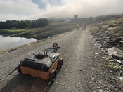
GSSI Announces the GS Series GPR Product Line for Geophysical and Environmental Surveys
GSSI, the world’s leading manufacturer of ground penetrating radar (GPR) equipment, introduces the new 200 MHz (200 HS) antenna, the first of the next-generation high-performance GS Series, designed for applications that require deeper depth penetration. The new 200 HS antenna serves as the foundation for the GS Series, which is ideal for geophysical, geotechnical, or environmental applications that require high reliability under challenging survey conditions. The newly designed 200 HS antenn...

Contech’s Cascade Separator Receives New Jersey Department of Environmental Protection Certification
West Chester, OH – Contech® Engineered Solutions announced today that the Cascade Separator has received New Jersey Department of Environmental Protection (NJDEP) Certification as an approved stormwater treatment device. The certification was awarded after the Cascade Separator successfully completed testing under NJDEPs rigorous hydrodynamic separator (HDS) laboratory testing protocol and exceeded applicable pollutant removal criteria. Designed with the aid of computational-fluid-dynamics mo...

Bluefin Technology Partners Develops Fluent with Walchem
Worcester Tech Company Builds Remote Monitoring System for Water Testing Devices Worcester, MA – Bluefin Technology Partners, one of Massachusetts’ most innovative digital product developers, today announced their partnership with the water treatment technology and equipment company, Walchem. Bluefin worked with Walchem to develop Fluent, a remote monitoring and reporting system which is fully synchronized with Walchem’s web based controllers, allowing for simple, fast and remote communicati...

FLIR Launches Industry-First Deep Learning-Enabled Machine Vision Camera: Firefly DL
ARLINGTON, Va. – FLIR Systems, Inc. (NASDAQ: FLIR) today announced the launch of the FLIR Firefly® DL, the industry’s first deep learning, inference-enabled machine vision camera with FLIR Neuro technology. With its small size, low weight, minimal power consumption, and deep learning capabilities, the FLIR Firefly DL camera is ideal for embedding into mobile, desktop, and handheld systems. The Firefly DL with deep learning enables original equipment manufacturers, engineers, and makers to qui...

Microdesk Launches ARID™, the First Cloud-based Asset Registry and Information Database Application for Enhanced Asset Data Management
New York, NY - Global AECO consulting firm Microdesk, announced today its launch of ARID™, a Cloud- based Asset Registry and Information Database application that leverages machine learning (ML) and artificial intelligence (AI) for enhanced asset data management. ARID™ allows organizations to capture and organize equipment assets in a central location and uses ML and AI to analyze assets names and values, identify inconsistencies and make recommendations based on industry standards. ARID™ is...

Concept3D’s New 3D Panorama Feature Simplifies Space Planning
Concept3D, a leader in creating immersive online experiences with 3D modeling, interactive maps and virtual tour software, today announced the launch of its new 3D Panorama feature, which integrates into the Concept3D interactive map and virtual tour platform. Hundreds of higher education institutions, convention centers, hotels, hospitals and businesses use the Concept3D platform to bring their space into the digital world and make it interactive for marketing, wayfinding, guest experience and...
Wingtra Launches Corridor Mapping with its 1.10 Release
The new corridor mapping feature in the latest (1.10) Wingtra software release enables fast, efficient coverage of long, narrow stretches with either of WingtraOne’s RX1R II or QX1 payloads. With the touch of a few buttons, customers can now enjoy the broad coverage and vertical take-off and landing (VTOL) operational flexibility that WingtraOne is known for when running large, linear plans. Wingtra corridor drone mapping features bring a new level of efficiency, as well as high accuracy and...
Autodesk Unveils Robust New Features for BIM 360
SAN RAFAEL, Calif. - Autodesk, Inc. (NASDAQ: ADSK) today announced enhancements to BIM 360, including a newly designed Layout app for mobile devices on Android operating systems. Autodesk also unveiled new BIM 360 features that make the project set-up process easier and increase collaboration between the field and the office, with expanded machine learning capabilities to better identify risk. Traditionally, construction layout and verification tasks were handled by one or two trained individ...

Latest Construction Field Software Uses Cloud Integration for More Efficient Workflow
Leica Geosystems, Procore further collaborate to bring interoperable workflows for construction (Heerbrugg, Switzerland, 9 October 2019) - Leica Geosystems, part of Hexagon, announced today a new software upgrade for Leica iCON field software as the first development under the collaboration with Procore, a leading provider of construction management software. The two industry-leading providers have integrated their services for collaboration across Leica iCON field software and Procor...
Video: Crashes Drop Measurably After Rural Road Safety Improvement Project on US 521 in Lancaster County

AdventHealth Weaverville Hospital

June Issue 2026
.jpg?width=225)