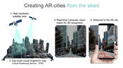
Sturfee Rolls out World’s First AR Cloud Technology for Cities that Uses Satellite Imagery to Create Magical City Experiences
Sturfee’s disruptive approach makes your smartphone cameras recognize streets using AI and Satellgery; major Japanese telco KDDI is already incorporating the production-ready tech for 5G services Milpitas, Calif. – Sturfee, a computer vision/AI solutions company, today emerges from stealth with the launch of its City AR technology, which uses satellite imagery and a mobile device to visually recognize the streets around you and digitally enhance them for applications ranging from navigation,...
Trimble Clarity Now Offered as Web Application for Point Clouds and 3D Models
SUNNYVALE, Calif.— Trimble (NASDAQ: TRMB) announced today that Trimble® Clarity is available as a stand-alone web application that simplifies the visualization and navigation of 3D data. With this major update, Trimble Clarity enables geospatial professionals to view, use and share 3D point cloud data, models and meshes with engineers, architects, city planners and other project stakeholders via a web browser, which can be viewed on desktop and mobile devices. The Trimble Clarity web applicat...
Trimble Announces Availability of the XR10 with HoloLens 2, a Next-Generation Mixed-Reality Solution for Front-Line Workers in Safety-Controlled Environments
DÜSSELDORF, Germany, Nov. 8, 2019—Trimble (NASDAQ: TRMB) announced today that it is now taking orders for the Trimble® XR10 with HoloLens 2 system, a worksite-ready mixed-reality solution that enables workers to visualize 3D data on project sites for easier and more efficient planning, collaboration and reporting. The announcement was made at A+A 2019, the largest international trade forum for safety, security and health at work. The new solution is enabled by two central components:...

Vectorworks, Inc. Brings Ultimate GIS Workflow to AEC and Landscape Professionals
Columbia, MD — GIS helps designers make better decisions. This is why Vectorworks, Inc., a global design and BIM software provider and its partner Esri, the global leader in location intelligence, are bringing Esri’s ArcGIS Online services to AEC and landscape professionals, as well as urban planners and urban designers. The solution offers better and quicker access to GIS imagery, data and geometry and the latest technology available in Vectorworks 2020 software, including Vectorworks Architect...

Cesium Takes City Visualizations Into the 3rd Dimension Through Open-Source Collaboration
Philadelphia – A new open-source initiative by Cesium™, the market leader in streaming 3D geospatial technology will address the need to visualize, analyze, and share the world’s vast and ever-growing collection of 3D geospatial data. Engineering teams from Cesium are working with Uber to add support for 3D Tiles to loaders.gl and deck.gl, two of Uber’s open source geospatial visualization frameworks. Support for 3D Tiles, an open-standard format originally created by Cesium, will enable dec...
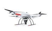
Microdrones is Taking Photogrammetry to New Heights with the mdMapper3000DuoG VHR
Rome, NY - Rome, NY – Microdrones is releasing three new Integrated UAV Systems based on the heavy lifting power, resilience and efficiency of the Microdrones md4-3000 aircraft: the mdMapper3000DuoG VHR, the mdMapper3000DuoG, and the mdMapper3000 PPK. The company has also updated the mdTector1000CH4 LR with a Pergam Laser Methane Falcon sensor for detecting Methane (CH4) and methane-containing gases. Additionally, Microdrones is preparing to release mdInfinity, a new software package t...
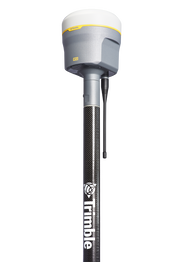
New Trimble R12 Receiver Boosts Surveying Performance
SUNNYVALE, Calif. - Trimble (NASDAQ: TRMB) introduced today the Trimble® R12 GNSS receiver, a high-performance Global Navigation Satellite System (GNSS) surveying solution. Powered by an all new Real Time Kinematic (RTK) and Trimble RTX® positioning engine, it features ground-breaking Trimble ProPoint™ GNSS technology that empowers land surveyors to quickly measure more points in more places than ever before. Surveyors who work in challenging GNSS environments can use the Trimble R12 receiver to...
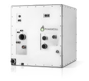
PowerCell to Present New Version of MS-100 Fuel Cell System for Electrification on Land and at Sea
PowerCell Sweden AB (publ) has developed a new and improved version of its MS-100 fuel cell system which will be presented at the Fuel Cell Seminar & Energy Exposition in California on November 5th. The new MS-100 is 30 percent more compact and has improved operating life time as well as robustness for demanding applications on land and at sea. The English version is an in house-translation. In case of any discrepancy, the Swedish text will prevail. The MS-100 fuel cell system has been de...
Eos Releases Underground Infrastructure Mapping Solution for Collector for ArcGIS
Eos Locate™ for Collector for ArcGIS enables utilities to map buried assets with submeter or centimeter accuracy MONTREAL, CANADA — Eos Positioning Systems, Inc.® (Eos) — the leading manufacturer of high-accuracy Arrow GNSS receivers — announced today the release of its highly anticipated underground utility asset-mapping solution: Eos Locate for Collector for ArcGIS. Eos Locate™ for Collector combines three core technologies: Eos Arrow GNSS receivers, Esri Collector, and the Vivax-Metrotech v...

Autodesk BIM 360 Design Now Offers Anytime, Anywhere, Cloud Collaboration On Projects With Both Infrastructure And Building Features
SAN RAFAEL, Calif. — Autodesk, Inc. (NASDAQ: ADSK) announces the expansion of Autodesk BIM 360 Design, Autodesk’s fastest-growing cloud solution, to include Autodesk Civil 3D. With this announcement, Autodesk now offers one of the most comprehensive solutions enabling teams to collaborate on complex projects with horizontal and vertical structures, nearly anytime, anywhere in a single connected cloud platform. Collaboration for Civil 3D, now included with a BIM 360 Design subscriptio...
Video: Crashes Drop Measurably After Rural Road Safety Improvement Project on US 521 in Lancaster County

AdventHealth Weaverville Hospital

June Issue 2026
.jpg?width=225)