
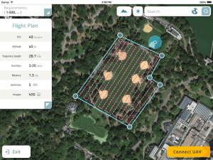
YOQNEAM, Israel, September 6, 2016 - Datumate, a market leader of automated "Field-to-Plan" solutions that save costly field and office time, is pleased to announce a new tablet app for effortless drone flight planning and automated, high resolution photo-shooting.…
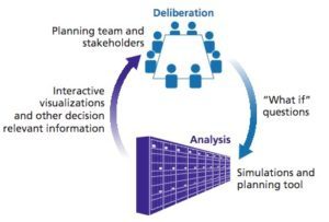
RAND and Lawrence Livermore National Lab Combine High Performance Computing and Public Policy Analysis for Demonstration of Water Resource Management
Researchers from the RAND Corporation and the Lawrence Livermore National Laboratory have joined forces to combine high-performance computing with innovative…
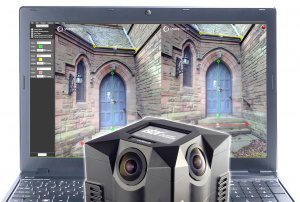
New SphereVision 360 Imaging Software Integrates iSTAR Measurement Module
Shepperton Studios, London – Arithmetica has released a new version of the SphereVision 360 degree imaging software with support for NCTech’s industrial…

Urbano 9.0.28.0 Released!
The main focus of this release was achieving full compatibility on all AutoCAD 2017 product versions. In particular, Urbano 9.0.28.0 provides: - support for Autodesk AutoCAD 2017 products - improved pipe intersection & clash analysis tool - improved pipe…
Innovyze Releases SWMMLive and ICMLive Generation V7.0, Powering Real-Time Stormwater, Wastewater and Watershed Modeling
Broomfield, Colorado, USA — leading global innovator of business analytics software and technologies for smart wet infrastructure, today announced the worldwide release of the V7.0 Generation of its SWMMLive and ICMLive for real-time operational forecasting,…
Drone Mapping Software Provider Pix4D Elevates Agriculture Software to Desktop & Cloud Solution, Launches Flexible Monthly Rental Option at InfoAg
Today Pix4D announces its first hybrid processing solution: this week, users of Sequoia with a license of Pix4Dmapper Ag will be able to process both locally in Pix4Dmapper Ag and on the Pix4Dcloud. Together with this announcement, Pix4D also introduces very…
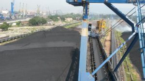
Successful Commissioning of Heap Profile and Volume Measurement System at ADANI
Further two reclaimers have been equipped with 3D laser measurement system at ADANI ports in Mundra, India. The system also includes a specific manager application, where a segmentation of multiple piles is shown as well as volume and weight information. A…
AirGon LLC Revolutionizes Drone Data Extraction
Huntsville, AL – AirGon LLC, a wholly owned subsidiary of GeoCue Group, Inc., announces the launch of Topolyst™, an advanced desktop application designed to make easy work of extracting information and derived products from point cloud and/or LIDAR data…

Autodesk Launches LIVE: Brings Interactive Storytelling to Life
SAN FRANCISCO, Calif., July 21, 2016 — Autodesk, Inc. (NASDAQ: ADSK) today announced the launch of Autodesk LIVE, a new interactive visualization service which offers Revit users in the architecture, engineering and construction industries (AEC) the ability…
NGRAIN Announces Open-Source Viewer for Android, Enabling Fast Creation of 3D Industrial Applications on Smart Glasses
Vancouver, BC, Canada – NGRAIN today announced the availability of NGRAIN Viewer for Android, a new app for Android tablets and smart glass devices, enabling the deployment of industrial 3D content created with NGRAIN Producer Pro. NGRAIN Viewer for Android…
