

Since the Environmental Protection Agency, and in turn state and local regulators, have gone all in on green infrastructure (GI) and low impact development (LID) concepts a seemingly regrettable consequence has emerged. Topics specific to the broader adoption…

gINT Supports Comprehensive Geotechnical Information Management System for the Municipality of Abu Dhabi City
The Municipality of Abu Dhabi City ensures sustainable development and enhances the quality of life for the Emirate of Abu Dhabi, United Arab Emirates.…
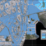
Federated GIS Based on Bentley Map Enables Cancún to Collect 66 Percent More Property Tax
Bentley Channel Partner Innovacion Sistemas y Proyectos (iSP) is a leading provider of geospatial information systems (GIS) services to local, state,…

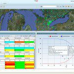
ScottishPower Strikes a Strategy for Asset Management and Process Safety
Energy company ScottishPower, a division of Iberdrola, was the first power generator and the second company in the world to be certified on BSI Publicly Available Specification 55 (PAS 55:2008), which benchmarks best practices, in asset management. AssetWise…

Improving Pipeline Information Sharing
On September 9, 2010, a section of natural gas pipeline in San Bruno, California, exploded leading to significant property damage and the death of 9 people. The cause of the explosion was ultimately traced to defective welds and a decision to increase the…

Sweco’s ‘Live BIM’ Railway Project Improves Efficiency on Hallandsås Project
The construction of a railway tunnel through the Hallandsås ridge in southern Sweden has a long history, but the end is in sight with the start of traffic services scheduled for late 2015. To help meet the demanding project schedule and the challenges of…

HR Wallingford Nears Completion on State-of-the-Art Marine Test Facility
Work to create one of the world’s largest maritime test facilities has entered its final stage following the completion of a £3 million development at HR Wallingford’s site in Oxfordshire, UK. Keys to the new 1,600 m2 building were presented to HR Wallingford…

Do We Still Need Geospatial Standards?
Since 1994, I have participated in, facilitated, and lead a variety of standards activities. I have helped develop standards in the OGC, OASIS, ISO, OMA, IETF, W3C – the list goes on. Given this commitment to the standards world, you might think that I have…
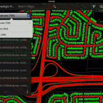
Mobile Apps Increase the Productivity of Infrastructure Professionals Working in the Field
When working in the field, it is important that personnel are able to view and analyze the most current infrastructure data. Bentley’s mobile Apps bring that information to field crews’ fingertips, whether they leverage that data in construction, maintenance,…
Situational Intelligence Aids Preparation for the Next Sandy
Severe weather – you can find it every day on the Weather channel, moving across America as large storms (often with tornadoes) that pose a direct threat to the lives and power supply for thousands of utility customers. Space-Time Insight situational intelligence…
