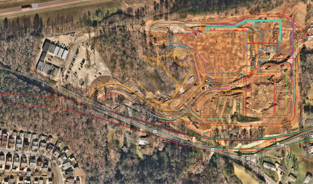
A digital dig board is a vital resource on an active jobsite where many trades are coming and going on busy schedules. Brasfield & Gorrie can provide all site personnel with immediate access to the in-ground utility locations with touchscreen ease. (Brasfield & Gorrie)
As the fundamental thread in a fabric of human cohesion, infrastructure in each of its many forms is as much an organism as it is a collection of systems. Organism or entity, in either case, change is inevitable. The relentless edge of innovation between what we’re doing today and what we’ll do tomorrow remains razor thin. Such is the case for Ryan Hittie, senior innovation and operational technology specialist with Brasfield & Gorrie, a large national construction firm with offices in eight states.
“To me, the most fascinating thing about construction is that outwardly the industry has a reputation for being sort of stubborn, not with the times,” says Hittie, who joined Brasfield & Gorrie in 2018 after starting his career in mechanical engineering for the oil and gas industry. “Those of us in commercial construction know that couldn’t be further from the truth.
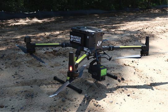
“When I was hired to manage the company-wide drone program five years ago, we had six drones. Now we have 38 drones, flying as many as 10 flights a day,” he explains. “My toolchest has expanded to include laser scanning, 360-degree-capture robotic cameras, and many layers of analytic automation. What I am looking at changes every day based on new software and new regulations.”
Headquartered in Birmingham, Ala., Brasfield & Gorrie is one of the largest privately held construction firms in the United States, operating in general contracting, construction, management and design-build delivery methods for a variety of markets. An estimated 3,500 construction professionals staff Brasfield & Gorrie projects from 13 offices across the southeast and Texas. The firm practices in most commercial and industrial sectors, including aerospace, healthcare, mission-critical, water/wastewater and heavy civil infrastructure.
“What unites the Brasfield & Gorrie experience are the people and technologies we bring to the table,” continues Hittie of the company culture. “Our purpose includes building strong communities. Whether we are talking about transportation infrastructure, airports, hospitals or manufacturing; all of it is tech driven. So our expertise and workflows must be tech-driven as well.”
Tech to Tackle High Demand, Low Supply
Asked where to begin on how technology is changing the game for commercial builders, Hittie notes an industry-wide concern in the forecasted labor shortage.
“Projections about the manpower available to the commercial building industry are bleak for the next decade,” he says. “Meanwhile, we are gearing up for some of the largest construction projects we have ever done.”
Solving problems virtually within a 3D model before the work begins has been a mainstay for the last 10 to 15 years for top firms such as Brasfield & Gorrie. Now savvy operators such as Hittie are doubling down as the project goes live. Hittie and the Brasfield & Gorrie team are using 3D models, aerial data capture and advanced analytics to optimize the project before and during construction.
“Technology helps address the labor shortage by allowing us to automate repetitive tasks,” he notes. “This enables our team to focus on intelligent problem solving. We are also leveraging technology to examine dangerous conditions and help keep people safe.”
The lynchpin of any design and construction equation—including safety—is information. Consequently, data reside squarely at the center of any thoughtful solution-building apparatus.
“One of the biggest shifts on construction sites to result from the digitization of things has been going paperless,” shares Hittie of the now-established benefits of the industry’s successful migration to BIM. “Now instead of having PDFs of drawings, everything is on an iPad, and we walk around with subcontractors coordinating the work in the model. Doing material take-offs, estimating design changes or getting shop drawings have all become routine on the touch screen.
“Using drones, we are going from site maps that are a day old to a site reciprocal that we can update in minutes,” he adds. “We use laser scanning to get a point cloud of existing conditions that we bring into the model. We then layer in other forms of data such as utility lines, soil conditions, traffic patterns, population, weather … virtually anything.”
Exact Locational Data
Illuminating the many facets of an intense conversation, Kyle Duncan, an innovation and operations tech specialist, joins Hittie in explaining how data get drawn together to become useful. Like Hittie, Duncan comes into his role at Brasfield & Gorrie from a lifelong fascination with his subject-matter expertise: geographic information systems (GISs) and the mapping of locational data.
“There is never a dull day in construction,” notes Duncan. “Our job is to solve problems, and sometimes those problems seem unsolvable, which challenges us to get creative. Just a few years ago, we were gathering GIS data via drones and doing a manual overlay to get an understanding of things. Today, the positional elements in the capture are so accurate that it takes the exact GPS coordinates of everything onsite within the imagery and automatically overlays them. We don’t have to do anything but upload the pictures.”
As an example, Duncan points to a project being constructed for a healthcare client in Birmingham in 2022. In observing what was supposed to be a routine gravel delivery, an astute project manager suspected the volume delivered didn’t match the invoiced quantity. In ordering a drone flight, the onsite tech flew the mission and scanned the pile of gravel. Using volume tools to measure the quantity, the imagery identified a 50,000-cubic-yard discrepancy, which the project manager was able to resolve without dispute.
“Having exact locational data of everything onsite means we can use it to track formwork for concrete as well,” explains Duncan. “Another project caught an ADA ramp that was formed up about 3 feet from where it was supposed to be. That would have been a $15,000 issue that would have taken several days to correct if it wasn’t caught.”
Beyond saving time and money by avoiding painful mistakes, Duncan wants builders to understand the tremendous value in workforce coordination and safety offered by digitizing the construction site.
“Typically, our projects have a Virtual Design and Construction coordinator onsite. As the work is being built, the model is being updated with each drone flight,” says Duncan of how all of this transmits back to the hands that do the work. “Using handheld tablets or phones, stakeholders can scan a QR code to see the drone map and how the site has changed. They can review the dig board; understand where all the utilities are; and track volumes, lengths and areas for their quantities. Using GPS, they can see what’s in the ground beneath them and everywhere around them at any time.”
Way beyond clash detection, it’s the digitization of reality that’s the vanguard moment here.
“This year, we began using drones to develop cut/fill patterns for largescale earthwork projects,” continues Duncan. “Flying a lidar payload, we are now shooting through trees and ground cover to develop precise topo maps of the undulating Earth. Combined with intelligent machines, the equipment is programmed to cut to the exact design file as set by the GPS coordinates gathered by drone-flown imaging.”
This workflow moves from drone and camera to blade and bucket via GPS coordinates without inference.
The Science of Where
Both Duncan and Hittie agree that because they have a lifetime of emersion in their respective technologies, despite the complexity, some of this is second nature to them. No matter how steep the learning curve may be, there are geospatial experts out there—none more recognized than Esri.
“Esri is what allows us to put all these layers of data onto a map in one place and convert it all to actionable insight in digital dig boards,” shares Duncan. “We can print a business-card-sized sticker with a QR code portal to the entire project information set. I’ve seen them on helmets.”
Like his counterparts on the implementation side, Esri Imaging and Remote Sensing Specialist Andrew Carey comes to his work through a fascination with the world around him as understood through technology. Before joining Esri, he spent 10 years in aerial surveying and mapping, combining imagery and remote sensing.
“Aerial imaging and mapping have been important tools in land management and civil engineering for a long time,” explains Carey from his Denver office. “Reality capture via drone has grown exponentially in architecture, engineering and construction. This is no longer a ‘pet project’; now it’s mission-critical for all sectors. The information gathered during a flight has started to become more of a data asset than a picture. Esri comes into play in mapping all that data and presenting the information gained in a relatable way.”
Headquartered in Redlands, Calif., and founded in 1969, Esri now has 49 offices worldwide, including 11 research and development centers in the United States. Esri’s ArcGIS is a suite of software products developed to allow users to integrate, store, edit, analyze, share and present geographic information to inform decision making.
“Esri operates on a principle we call the ‘Science of Where,’” continues Carey. “Our systems allow users to transition to a data-first perspective. Beyond automatically extracting quantities, calculating clashes or identifying avoidable mistakes, change detection can identify everything different and how much has been accomplished from one flight to the next. Our software converts all this locational intelligence to web-based, user-ready project dashboards.”
The synergies among GIS locational data and 3D modeling have only just begun to come into focus. Whereas design used to start with pencil and paper, architecture and engineering started transitioning in the 1970s to CAD files on computers. During the next 40-plus years, as CAD technology advanced, software programs began to diverge to become more specialized; programs focused on architecture, mechanical engineering or civil engineering emerged. In the early 2000s, virtual 3D building models started their takeover. However, the design process still began in black space rather than with the precise locational data as it exists in the real world.
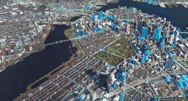
In 2019, Esri announced a partnership with Autodesk focused on increasing the ease of integrating the vast troves of GIS data that exist within the software programs used to design the built environment. To give an example of the paradigm shift, Carey points to a hypothetical site in downtown Boston as an example of what’s possible.
“Using aerial imagery taken of Boston with locational data, we have a 3D real-world capture of all the roads, bridges, buildings, traffic lights and everything else there in exact scale,” he explains. “Through our partnership with Autodesk, all of that is accessible in a BIM model, which affords designers the possibility of planning egress, access, pedestrian circulation and all the things that take place outside the building form from an information-driven understanding of reality.”
To reach the next level of intelligent design, users integrate all the supplemental information that exists locally, regionally, nationally and globally. As a starting point, Esri’s Living Atlas is a collection of datasets taken from a conglomeration of sources that allows users to conduct keyword searches to discover data of interest. Example datasets within the Living Atlas include known soil conditions, NOAA survey control points, FEMA floodplain information, the national bridge inventory and many others. Adding each of these layers of information takes just a few mouse clicks—processes that used to take hours to research and overlay.
What’s more, in many cases, data published by a city, county, state or country can include intelligence on power lines, water and sewer lines, fire hydrants, and roadway dimensions—all of which are easily integrated by a knowledgeable operator.
“For Esri, understanding the world around us comes down to three key considerations: System of Record, System of Insight and System of Engagement,” explains Carey. “What is the new information; does it give me something I didn’t understand before; and how do I engage this new insight? Answering these three questions is where data bring value to solution building.”
Asked what’s on the horizon, Carey reminds us that the possibilities are infinite.
“We flew all 700 acres of the historic Red Rocks amphitheater west of Denver,” summarizes Carey. “We made a beautiful 3D model of the entire mountain park, which is being used for event planning and management, environmental protections, and pre-thinking everything from the weather and parking to water usage, waste disposal or disaster management. They can run ‘what-if’ scenarios on whatever they can think of.”
Back at Brasfield & Gorrie, Ryan Hittie has simple advice for those seeking the edge of innovation. “Embrace new technology by finding people who already have a passion for it, and they will amaze you.”

Sean Vincent O'Keefe
Sean Vincent O'Keefe is an architecture and construction writer who crafts stories and content based on 20 years of experience and a keen interest in the people who make projects happen; email: [email protected].
Video: New Roundabout Under Construction at McIver and Old Florence Roads in Darlington County

Bridge Replacement at Amsterdam Centraal Station

June Issue 2026
.jpg?width=225)