
Waskita Karya Designs Toll Road Network to Support Development of Indonesia’s New Smart Sustainable Capital City
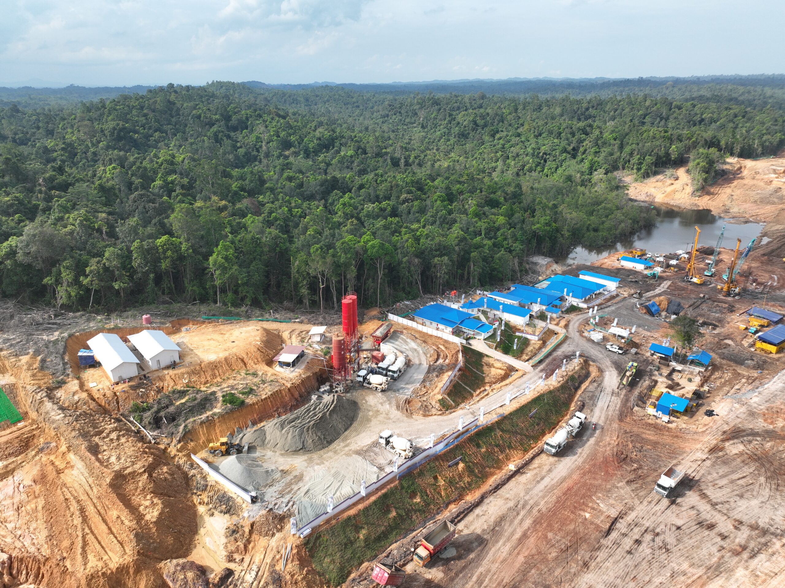
The digital twin solution improved communication, eliminating 20,000 truck movements during initial construction, lowering diesel fuel consumption by 32,800 liters to save IDR 590 million. (Credit: PT Waskita Karya (Persero) Tbk)
Nusantara (IKN) is scheduled to be inaugurated in August 2024 as Indonesia’s new national capital, replacing Jakarta. Spanning approximately 2,560 square kilometers, the newly planned city is located on the east coast of Borneo in East Kalimantan province, surrounded by hilly landscape, forest and a natural bay. Being built with a national identity that promotes economic transformation and tourism, the metropolis is utilizing artificial intelligence (AI) and advanced technologies to support sustainable transport, renewable energy and green development. Connecting roads, government offices, utilities and all necessary infrastructure are being constructed to achieve intelligent, sustainable industrial development, protecting surrounding forests and facilitating zero carbon emissions to become a world-class smart forest city.
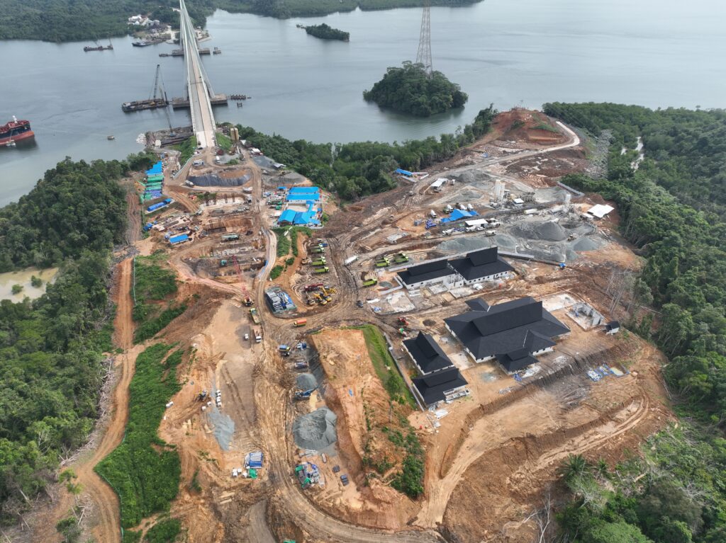
As part of this smart city megaproject, 75.62 kilometers of toll road infrastructure is being constructed to improve connectivity and shorten travel times between the city of Balikpapan and the capital’s Central Government Core Area (CGCA) from 2.5 hours to 30 minutes. PT Waskita Karya is the main contractor responsible for the 6.675-kilometer Simpang Tempadung-Jembatan Pulau Balang section 5A of the roadway network, connecting the new IKN VVIP Airport to the CGCA via the existing Pulau Balang Bridge.
“As the main contractor, having a good data communication system between stakeholders is essential to ensure the project is within schedule,” says Indah Nurcahyani, BIM engineer at Waskita Karya.
Site Constraints, Design Compatibility and Change Management
While the new purpose-built capital is strategically positioned in the middle of the Indonesian archipelago, the area’s topography consists of lush, hilly rainforests dominated by soft soil and clay. “One of the conditions to be considered in determining the design is the extreme terrain, which requires cutting several hills, and the geological conditions, dominated by soft soil and clay layers,” explains Nurcahyani.
Compounding these site constraints is the need to align the toll road with the Pulau Balang Bridge, which has already been built. From the initial 3D models, Waskita Karya realized that the basic roadway design plan didn’t support the existing bridge. “There is a horizontal alignment difference of about 1.5 meters; for vertical alignment, there is an average elevation difference of 4 meters,” adds Nurcahyani.
The difference in distance and elevation between the toll road and bridge had to be discussed with numerous stakeholders located far from the project site, and a design decision was reached quickly to keep the project on schedule. To address these design compatibility issues while ensuring structural integrity amid the challenging terrain and tight construction schedule, Waskita Karya wanted to establish a coordinated design review process that allowed for potential design changes, adjusting the toll road to meet the existing bridge parameters.
“The primary and essential focus is reviewing and changing designs quickly, precisely and accurately,” notes Nurcahyani. Waskita Karya needed an easy, fast and accurate multidiscipline collaboration platform so the team and stakeholders could virtually visualize and communicate to make timely, optimal decisions regarding design changes.
Establishing Collaborative Workflows and Digital Twins
Waskita Karya set up a common data platform using Bentley Systems’ ProjectWise for all participants to access current project information. With Bentley’s iTwin, it established a real-time, cloud-based design review environment. Waskita Karya performed a site survey using drones to capture high-resolution imagery of existing topography and bridge conditions and, using iTwin Capture Modeler (formerly ContextCapture), processed the images into a reality mesh.
An image shows where an existing bridge meets with a toll road. (Courtesy of PT. Waskita Karya (Persero))
“We captured over 10,000 images and processed them in iTwin Capture Modeler, generating a high-fidelity 3D model of the existing bridge that was then uploaded to the cloud,” explains Nurcahyani. Integrating Bentley’s open 3D modeling applications, they created a 3D design model and digital twin of the bridge and toll road.
Working in a collaborative digital environment, the team reviewed and commented on the models and performed clash detection to virtually predict potential construction issues. As discussions progressed and the team made decisions regarding design changes, they seamlessly updated and synchronized the models via Bentley’s iTwin Platform, eliminating time-consuming file import and export processes. Field crews also had access to the digital twins via tablets to record their inspections directly on the models.
“Working with the 3D digital twins means the field team could inspect the basic design plan remotely, record their findings directly on it, and accurately pinpoint the areas in need of repair,” notes Nurcahyani. The cloud-based digital twin solution streamlined collaboration among Waskita Karya’s designers and construction personnel, accelerating informed decision-making to ensure bridge and roadway alignment and keep the project moving forward.
Connected Digital Ecosystem Industrializes Delivery
Bentley’s integrated modeling applications provided a connected digital ecosystem to generate digital twins and perform real-time coordinated design reviews, reducing design time by 40 percent and field inspection time by 50 percent.
“The digital twins provide valuable data and information and function as a communication tool, enabling real-time collaboration and problem solving among the team, without disrupting current processes,” adds Nurcahyani. By optimizing the horizontal and vertical alignment of the road within a 3D virtual design environment, Waskita Karya saved IDR 12.5 billion in potential rework costs in just the first kilometer of the design plan.
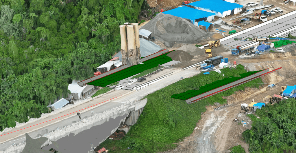
A Reality Mesh overlays 3D Models in the New Capital City. (Courtesy of PT. Waskita Karya (Persero))
Using Bentley software as an environmental and digital design and construction management platform, Waskita Karya could link multiple datasets, resolving visibility issues and providing accurate material information to construction teams. This practice saved critical time and costs while achieving higher-quality deliverables compared to previous design workflows. The digital twin solution improved communication among engineers, field personnel and stakeholders that eliminated 20,000 truck movements during initial construction, lowering diesel fuel consumption by 32,800 liters to save IDR 590 million. Establishing a connected digital ecosystem and single source of truth enhanced design quality, mitigated risks and provides a solid digital framework for construction. “The project is now under construction, and we anticipate a more accurate design to minimize the need for [on-site] rework and associated costs,” says Nurcahyani.
About Meg Davis
Meg Davis is the industry marketing director for Bentley’s road and bridge solutions from planning through operations; email: [email protected].
