
San Francisco Bay’s Treasure Island—a flat, 400-acre, rather headstone-shaped island—is entirely artificial, “… constructed by emplacing 260,000 tons of quarried rock in the shoals for the island/causeway perimeter rock walls (a freshwater reservoir was quarried in the rock of Yerba Buena Island). Approximately 23 feet of dredged bay sand filled the interior, was mitigated from salt, and then 50,000 cubic yards of topsoil was used for planting 4,000 trees, 70,000 shrubs and 700,000 flowering plants.” (Wikipedia)
“It’s a very interesting story,” says Uri Eliahu, G.E., president of multinational geotechnical firm ENGEO. “It was built in the 1936/1937 timeframe, with a near-term purpose and a long-term purpose. The near-term purpose was to house the 1939 World’s Fair, which it did—judging from pictures, it must have been quite a spectacle. And the long-term purpose was for the island to become the San Francisco Airport—after the World’s Fair. So three buildings built for the fair were intended for subsequent airport use: the iconic horseshoe-shaped, art-deco building you see when you first drive onto the island was to be the terminal for the airport, and two large hangar buildings, all of which are historic and being preserved. And then what happened, of course, was a little thing called World War II.”
The U.S. Navy’s 1942 seizure of Treasure Island—as a site for Naval Station (NAVSTA) Treasure Island—was more than a little contentious at the time. But 70 years later, NAVSTA Treasure Island use as (among other things) a Naval Auxiliary Air Facility to support helicopters, fixed-wing planes, seaplanes, blimps, dirigibles and airships; a U.S. Navy/USMC electronics school; a “Radar Bomb Scoring Site” and Strategic Air Command (SAC) automatic tracking radar facility; and site for a psychiatric ward used to study and experiment on naval sailors who were being discharged for being homosexual—while remaining as controversial as all military matters—in retrospect might also be viewed as a stroke of good luck.
Had the airport gone forward in the 1940s, as planned, it would have been built on a site that has since subsided substantially in places. With construction technology based on the era’s relatively limited understanding of sea-level rise, geotechnical factors and seismic forces, it could have proved disastrous during the 1989 Loma Prieta Earthquake (i.e., the “World Series Earthquake).
“Recordings obtained during the main shock of the Loma Prieta earthquake as well as during subsequent aftershocks showed significant amplification at the soft soil Treasure Island site, where recorded peak accelerations were more than two times higher than those at Yerba Buena Island,” (emphasis added) noted “The Loma Prieta Earthquake, 25 Years Later,” a 2014 paper by Verisk (bit.ly/3IGNyhT).
Land Boom
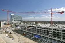
NAVSTA Treasure Island was officially closed on Sept. 30, 1997, and nearly all the island’s 400 acres now are leased to the City of San Francisco, creating something of a miraculous land boom for the nation’s second-most-densely populated city. The historic and enormous hangar buildings quickly were converted for use as sound stages (“The Matrix,” among other productions, was filmed there), and currently the island is “… open to the public and home to over 2,000 residents, commercial tenants, restaurants, schools, arts and athletic organizations and community organizations, and a Job Corps campus,” according to the Treasure Island Museum’s website.

That still leaves a lot of room for a “sustainably designed redevelopment project” that will create about 8,000 residences, a commercial center and plenty of open space. Providing a firm foundation for that development and making the island resilient in the face of expected sea-level rise and the possible “big one” (large earthquake) that Bay Area residents must always account for, has been a massive, decades-long geotechnical remediation project for ENGEO. The firm’s engagement began in 2003 with a brief due-diligence exploration for one of the eventual development partners, and “we began our work in earnest in 2007,” says Eliahu. “Since then, it’s probably not the largest project we’re involved with, but it may currently have the most ‘moving parts,’ and it certainly has the broadest variety of technical challenges.”
The most important of these challenges is a consequence of Treasure Island’s artificial, layered construction, which created some layers subject to liquefaction, a phenomenon in which the strength and stiffness of a soil is suddenly reduced by earthquake shaking or other rapid loading, causing tremendous damage to infrastructure. And the danger at Treasure Island isn’t at all imaginary: “We experienced liquefaction in the 1989 Loma Prieta earthquake—the ground acceleration on the island at that time was in the range of 0.15g,” explains Eliahu.
In engineering applications, peak ground acceleration (PGA) is the most-used measure of ground acceleration during earthquakes and is usually expressed in fractions of g: the standard acceleration due to Earth’s gravity, equivalent to g-force. The 0.15g figure recorded at Treasure Island in 1989 is a very high figure but is only a small fraction of the seismic force ENGEO was asked to accept as a design constraint for the stabilization work. “The earthquake we designed for—the possible ‘big one’ if you will—is a little more than three times as powerful as Loma Prieta, say 0.45g to 0.50g,” notes Eliahu. “Well, you can imagine what that would be like.”
Indeed, the estimated seismic risk being planned for was so great developers first assumed a rather radical containment strategy would be required for long-term mitigation—early redevelopment plans essentially called for deep piles and subsurface “fencing” around the entire island perimeter that would hold together island layers liquefying during an earthquake, rather as a springform cake pan holds together cake batter until the batter solidifies during baking. It’s a radical and expensive proposal but thought necessary to stabilize an island consisting of five layers, some of which were known to liquefy during dynamic loading.
But ENGEO learned during early testing and soil analysis—and was able to prove—that the existing picture of Treasure Island’s layered construction wasn’t nearly so dire as assumed, and there was reason to expect good performance from some layers during an earthquake. This made possible a more-targeted approach to soil stabilization and infrastructure foundations that was a higher-quality solution and less expensive overall.
“What had been contemplated was some sort of a robust containment system around the island to contain any liquefied materials and then placing every building on very deep foundations,” says Eliahu. “But after we did some of our early work, we felt like a better approach would be to put the resources into areas where the buildings will be and, of course, the infrastructure that supports those buildings, and mitigate liquefaction. In other words, prevent liquefaction within the building footprints, rather than try to contain the entire liquified mass.”
And that’s the seismic risk-mitigation strategy that ended up guiding the redevelopment of Treasure Island, a major change from initial plans that was the result of an exceedingly thorough investigation of the actual composition and performance of some of the island’s layers.

A Five-Layer Island
The 1936-37 construction process created an island of five distinct layers, described by Eliahu as follows:
1. “Starting from the top,” he explains, “is this artificial fill, about 25-45 feet, that, if unmitigated, is liquefiable—it would be susceptible to liquefaction in an earthquake, under dynamic loading.”
2. “Beneath that, we have 20-25 feet of ‘natural shoal deposit,’ we call it, also thought to be liquefiable. That’s the material that, over geologic time, came off Yerba Buena Island primarily by erosional processes.”
3. “Beneath that, we have a very compressible bay mud, so that if unimproved would cause significant settlement when new loads are added.”
4. “And underneath that we have a stiff clay that’s actually quite competent.”
5. “Finally, below that, we have bedrock at a depth of 300 feet, although it varies.”
Of most interest to ENGEO were the top two layers: about 50 feet of artificial fill susceptible to liquefaction yet capable of ground improvement via vibro-compaction and other measures. Also of interest, of course, was the “compressible bay mud” layer. And “of interest” is understating the capacity of each layer; San Francisco’s Millennium Tower, a 58-story highrise about three miles away, has sunk 18 inches since completion in 2009.
“So that was the challenge,” Eliahu explains. “We have seismic susceptibility—if we get a big earthquake, the top two layers of fill could have liquefied. And we have a condition where if we add any new weight, that might trigger new settlement of the bay mud that’s under the liquefiable soil.”

Investigative work began by peeling back the pavement in the middle of a parking lot to reveal a patch of fill not far from the island’s cityside shore—the test plot had a nice view of San Francisco, actually. Then in June 2015, a “53-ton, 75-foot-long Jafec 40,000 Direct Power Compactor” was imported from Japan (along with a 10-man Japanese crew), suspended over the site from a 280-ton crane, and used to “pound sand” about as powerfully as sand has ever been pounded in North America.
The Jafec DPC is cutting-edge technology, featuring no less than four massive vibrating prongs (technically, a “quadruple axial rig with a vibro-hammer at the top of each pile”) that are “repeatedly smashed” (probably not the technical term, but when 53 tons of vibrating multi-probe hit the ground …) into soil with vibration, tamping and compacting effect. The immediate, visible effect on Treasure Island’s artificial fill layer was dramatic—initial vibro-compacting tamped compressed fill 2-3 feet and drove out a lot of water. And it’s more than just tamping, which can only compact, at best, about the top 25 feet of island sand. The Jafec machine can nearly double that, theoretically stabilizing the island’s top two layers of artificial fill and natural shoal deposit.
“Vibro-compaction is by far the best means of densifying the island—far more effective than tamping,” adds Eliahu. “For us geotech guys, this is about as good as it gets.”
A Possibly Troubling Result
But remember, this was investigative work; a pilot test of technology that had been applied in Japan, but not in the United States. Before-and-after comparison of “cone penetrometer test (CPT) signatures” (a test in which an instrumented cone is pushed into the ground at a controlled rate) revealed a surprising, possibly troubling, result. Put simply, nearly all the soil loss and compacting effect of vibro-hammering was observed only in the top 25 feet of artificial fill, with minimal observed effect in the bottom natural shoal deposit layer.
A possibly troubling result because it might mean that vibro-compaction, as powerful a technology as it is, would not be as effective as needed in the difficult conditions at Treasure Island. But on the other hand, there was a possibility that the minimal impact on the natural shoal deposit layer was very good news; it might mean the natural shoal deposit was more competent than expected, despite being pretty much the “same stuff” as the artificial fill.
“We have about 24 feet of the hydraulically placed fill sitting on top of a similar amount of the natural shoal—now, remember they’re both the same stuff,’” says Eliahu. “But what we saw is, in the upper 23 feet we got huge improvement—way more improvement than was necessary—but below that, we see no improvement. So the layer that was placed by pump dredges was very receptive to densification, but somehow when Mother Nature placed the natural shoal layer over thousands of years, it became very resistant to the dynamic energy we applied.”
So verifying and understanding the better-than-expected performance of the natural shoal layer became ENGEO’s top priority, as it would affect all development going forward. This proved to require advanced scientific and engineering analysis, ultimately involving the use of piston sampling to obtain delicate core samples.
“Basically, we did testing to see if we could do testing,” says Eliahu. The samples were subjected to dynamic loading (simulated earthquakes) and advanced analysis (including scanning electron microscopy), detailed cross-sections and geologic mapping, and the assembly of a blue ribbon panel of engineers, mathematicians and academics. All this work was well worth doing, as in the end it conclusively demonstrated that the naturally deposited layer, despite incorporating the same materials as the artificial fill, was less susceptible to liquefaction during earthquakes.

Interestingly, it was the fact of natural deposition that made the difference. “The way the shoal material was put down over thousands of years was through wave action,” explains Eliahu. “And when the tide was slack, when the water was gone, tiny amounts of clay would deposit, as it does over the rest of the bay. Also, there would be these periods of erosion from Yerba Buena Island. And in addition to that back-and-forth wave action and erosion, which packed the sand more efficiently, there was biological activity there, called bioturbation—that’s basically little critters eating, pooping and dying. And so all that created a fabric, a matrix, that made the layer resistant to vibro-compaction.” And resistant to earthquakes, too, as it turns out; the newly discovered stability of the natural shoal layer, even under violent dynamic loading, was so great that it made possible the more infrastructure-targeted—and higher-quality and more cost-effective—geotechnical strategy described above.
So a big win for San Francisco and the development of Treasure Island. And a big win, too, for the whole field of geotechnical engineering.
“This is the first time I’m aware of that the ability of natural processes causing a quite robust deposition resulting in layers resistant to liquefaction became a factor in the field,” adds Eliahu. “It wasn’t new knowledge, exactly—there was some awareness in academia, for instance by Professor Nicholas Sitar at UC Berkeley—but it’s certainly a new idea in large-scale development in the Bay Area.”

Some of the island’s shoreline, notably near the ferry terminal and along the causeway connecting to Yerba Buena Island, was still “contained” with a combination of deep soil mixing and shear walls perpendicular to the shoreline, up to 90 feet deep. And even under the modified geotechnical plan, a lot of ground improvement has been necessary.
“The entire development footprint receives a multistep ground-improvement process,” says Eliahu. “Wick drains to allow the water to escape the compressible bay mud in a reasonable amount of time; upper-layer densification via deep-power compaction, which is that big rig from Japan; an engineered fill; and a temporary fill on top of that, which resides for months to achieve compression.”
It’s a huge project, and it’s nearing completion. The ferry-terminal complex is complete and has been operating since January 2022, and major new infrastructure now is being built in the rest of the development.
Was it all worth it? “Well, we’re reclaiming land whose prior purpose had run its course,” notes Eliahu. “And we are doing it in a way that is dynamically stable, can resist the most-severe earthquakes, accommodates sea-level rise and makes it habitable. It’s quite rewarding really. I couldn’t be prouder of our staff at ENGEO as well as the eagerness, alacrity, deep thinking, enthusiasm and passion they’ve put into this. We all realize it’s an iconic project and that we have to get it right every day.”

Angus Stocking
Angus Stocking is a former licensed land surveyor who has been writing about infrastructure since 2002 and is the producer and host of “Everything is Somewhere,” a podcast covering geospatial topics. Articles have appeared in most major industry trade journals, including CE News, The American Surveyor, Public Works, Roads & Bridges, US Water News, and several dozen more.
Video: New Roundabout Under Construction at McIver and Old Florence Roads in Darlington County

Froedtert Hospital Expansion
June Issue 2026
.jpg?width=225)