
BTS Releases Spring 2021 Updates to National Transportation Atlas Database (NTAD)
U.S. Department of Transportation sent this bulletin at 04/29/2021 11:00 AM EDT
National Transportation Atlas Database Spring 2021 Includes New Pipeline Dataset, 8 Other Updates
The Spring 2021 update to the National Transportation Atlas Database (NTAD) was released today with the new pipeline intermodal freight facility layer and eight updated datasets.
The pipeline addition brings to 89 the total number of geospatial datasets in the NTAD collection representing the nation’s transportation infrastructure, containing roadways, railways, waterways, and airports. An additional 27 ancillary data tables can be used in this Bureau of Transportation Statistics (BTS) compilation.
The updates in this release include:
- National Bridge Inventory with 2020 characteristics;
- National Tunnel Inventory with 2020 characteristics;
- Alternative Fueling Stations including electric vehicle charging stations;
- National Parks;
- Metropolitan Planning Organization (MPO) boundaries;
- Military Bases;
- Marine Highways; and
- Strategic Ports.
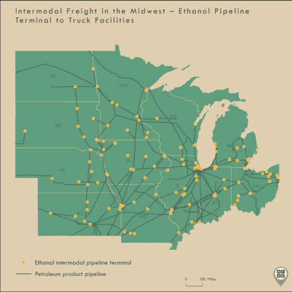
The pipeline intermodal freight facility layer includes information on the mode (truck, rail, and/or waterway) a pipeline terminal connects to, what commodity the facility can manage (crude oil, refined petroleum products, petroleum chemicals, natural gas liquids, gasoline, biodiesel, jet fuel, and ethanol), and its storage capacity.
The map below shows the location of the ethanol intermodal pipeline terminals in the Midwest, specifically those that connect to truck facilities. The highest number of ethanol intermodal pipeline terminals in the U.S., 164 out of 463, are in the Midwest, the region with the top 10 corn producing states. In the U.S., ethanol is largely produced from the starch in corn grain.
NTAD is available for download in comma separated values (CSV), Keyhole Markup Language (KML), and shapefile formats through the BTS Geospatial Data Catalog. Additionally, Open Geospatial Consortium (OGC) standard Web Feature Services (WFS) (including Web Mapping Services (WMS)) are available for all NTAD datasets. Also available are optimized services that allow for fast rendering of full NTAD datasets, and vector tile services for 13 of the largest NTAD datasets. These full NTAD datasets and their respective faster services are designated by service names ending in “DS” for each layer, and the vector tiles service names ending in “VT”.
BTS now uses a dynamic NTAD publication cycle, making updated data available throughout the year when they become available from their respective government agencies. Follow @TransportStats on Twitter for announcements of additional dataset releases throughout the year. Contacts: Press: Dave Smallen: (202) 366-5568. For technical information and questions: Dominic Menegus: (202) 366-8717, or email [email protected].
