
Leica Geosystems updates the Leica ConX cloud-based collaboration tool with new functionalities
(HEERBRUGG, Switzerland) – Leica Geosystems, a Hexagon company, today announced to further extend its offering for Leica ConX, cloud-based collaboration tool with the addition of Leica Captivate, surveying field software, and functionality for drill rig, pile driver, dozer and motor grader solutions.
In this very competitive environment, construction companies need solutions that are helping boost productivity, efficiency, and safety. Therefore, it is key for Leica Geosystems to offer management cloud solutions to enable construction companies gaining control of their jobsite and its constantly changing conditions.
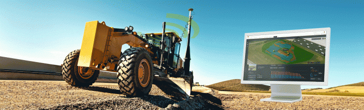
Leica ConX enables to track and visualise complete fleet of assets, as well as to sync design files between multiple construction machines and surveying crews. By using the latest release of ConX, construction teams can save time and enhance workflows both in the field and office with seamless collaboration and data flow across the complete life-cycle of a construction project. Since Leica ConX is already integrated in Leica Infinity and Leica iCON office, with the new update, using ConX within Captivate surveying software, there are now quicker ways to exchange data between the field and the office.
Enabling the exchange and seamless flow of field, office, machine and surveying data, with the new update, the drill rig and pile driver interface allow real-time visualisation of updates on completion of drill holes or piles in the office, without even being on-site.
“With the new ConX update, we want to continuously offer our customers state-of-the-art cloud solutions to track, visualise and sync real-time data from the jobsite into the office. It is key for our customers that we provide valuable data outputs into ConX and enable them to make fast business decisions without even visiting their jobsites”, says Kris Maas, director of product management for machine control at Leica Geosystems.
Digitised workflows in real-time
Cloud-based collaboration solutions provide a competitive advantage by enabling real-time information flow among machines, construction teams on the jobsite and in the office. All critical project information from reference models, unit locations and history, and measured as-built information is visualised in real time on 3D overlay base maps for an intuitive and quick overview of the project progress. With Leica ConX, even non-experienced users will be able to visualise and validate localised reference models, survey data and constructed data.
This innovation is available for hands-on demonstrations at CONEXPO-CON/AGG 10-14 March 2020 in Las Vegas, United States, on the Hexagon Booth in North Hall, at stand #N-12166.
Leica Geosystems – when it has to be right
With more than 200 years of history, Leica Geosystems, a Hexagon company, is the trusted supplier of premium sensors, software and services. Delivering value every day to professionals in surveying, construction, infrastructure, mining, mapping and other geospatial content-dependent industries, Leica Geosystems leads the industry with innovative solutions to empower our autonomous future.
Hexagon is a global leader in sensor, software and autonomous solutions. We are putting data to work to boost efficiency, productivity, and quality across industrial, manufacturing, infrastructure, safety, and mobility applications.
Our technologies are shaping urban and production ecosystems to become increasingly connected and autonomous — ensuring a scalable, sustainable future.
Hexagon (Nasdaq Stockholm: HEXA B) has approximately 21,000 employees in 50 countries and net sales of 3.9bn EUR. Learn more at hexagon.com and follow us @HexagonAB
