
FARO Leads in Virtual Reality for Construction, Design and Forensics
Lake Mary, FL - FARO® (NASDAQ: FARO), the world’s most trusted source for product design, construction BIM/CIM, and public safety forensics announces the release of Virtual Reality (VR)-ready FARO® SCENE 7.1 software (http://www.faro.com/scene/sg). FARO SCENE 7.1 enables an immersive VR experience with integration of detailed photographic textures, i.e., surface details of an object and rendering of 3D scan data so quickly that it appears to be generated in real time. A free 30-day trial...

Autodesk Powers the Future of Manufacturing and Construction with Forge
At Autodesk University, Autodesk announced that developers and customers of all sizes are adopting its Forge developer platform to build and deploy apps and services to drive the future of making things in manufacturing and construction. A new platform update has also been launched to make building on Forge even easier. Next-generation cloud application framework The design and engineering world is undergoing a major disruption from a single-user, file-based, desktop CAD experience to a de...

Sulzer Announces MIXPAC MixCoat Manual Protective Coating Dispensing System
Sulzer Mixpac USA, Inc., the leading innovator of 2-component adhesive dispensing systems, announces the availability of MIXPAC™ MixCoat™ Manual, a member of the innovative MIXPAC™ MixCoat™ cartridge-based 2-component dispensing system family. The MixCoat Manual protective coating dispensing system features a lightweight design with a unique brush assembly on a manual dispenser, which greatly increases stripe coating productivity and speed. The MixCoat Manual system is ideal for repairs and rope...
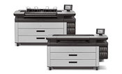
HP Introduces Faster PageWide XL Printers for Enhanced Technical Production
LAS VEGAS, Nev. — Today at Autodesk University, HP Inc. announced new HP PageWide XL printers with sharp, up to 70 percent faster1 output, enabling technical production providers to grow AEC volume and expand business in color applications with the market-leading HP PageWide XL printer portfolio. The new HP PageWide XL 5100 and HP PageWide XL 6000 printers and multifunction printers strengthen the fastest printer portfolio in the market2 to equip enterprise print rooms, central reprographic d...
Esri Collaborates with Mobileye to Bring Real-Time Sensor Data to Public Transit
REDLANDS, Calif.— Esri, the global leader in spatial analytics, today announced a collaboration with Mobileye, an Intel Company and a leading provider of advanced driver-assistance systems software, to integrate Esri mapping, analysis, and visualization with Mobileye’s Shield+™ product. This collaboration will provide cities with the ability to visualize and analyze real-time location data from Shield+, improving safety for all road users in urban environments. Mobileye’s Shield+ will stream...

New Laser Scanner Offers Up to 1 Km Long Range Scanning Capability
(Heerbrugg, Switzerland) – Leica Geosystems, industry leader of measurement technology, announced today the Leica ScanStation P50, the fastest and safest long-range 3D laser scanner, as the newest member of the 3D terrestrial laser scanner P-Series. The new ScanStation P50 combines all the well-known features of the P40 plus a longer-range scanning capability of more than 1 kilometre. Increasing users’ flexibility to offer services in new markets, this rugged and versatile laser scanner enabl...
IMAGINiT Clarity 2018.1 Now Available for Revit, Collaboration for Revit and Revit Server
OWINGS MILLS, MD ― November 14, 2017 — Software development experts from IMAGINiT Technologies will be at booth B109 at Autodesk University (AU) 2017, to demonstrate key features of the newly released IMAGINiT Clarity 2018.1. Clarity allows building project teams to access Autodesk Revit software model data in new and insightful ways giving Building Information Modeling (BIM) teams greater visibility over models while saving time and effort. “Giving BIM coordinators better access and uti...
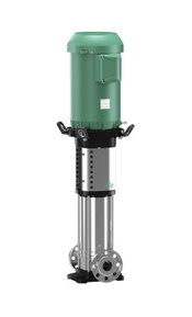
Wilo USA Releases New Product Range to Stand-out Helix V Line
Rosemont, IL. Wilo USA, a provider of pumps and pump solutions for water management, building services and groundwater, is pleased to announce the release of extended range versions of the Wilo Helix V high-efficiency multistage pump line. The Helix V is a non-self-priming, high-pressure, vertical multistage centrifugal pump with inline connections and is suitable for a wide range of applications including water supply and pressure boosting, industrial circulation systems, washing system...

Autodesk Previews Next Generation BIM 360 Platform Connecting the Entire Construction Process
LAS VEGAS — At its 25th annual flagship user conference, Autodesk University, Autodesk, Inc. (NASDAQ: ADSK) previewed its next generation BIM 360 platform, a seamless cloud service connecting the entire construction project lifecycle. Autodesk also launched the “Connect and Construct Exchange,” a new BIM 360 integration partner program designed to bring third-party software applications and data into the BIM 360 construction workflow. The Connect and Construct Exchange launched with more than 50...
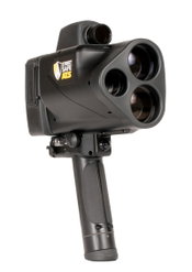
American Traffic Solutions Partners with Laser Technology Inc. To Launch ATS StreetSafe
MESA, Ariz. - American Traffic Solutions (ATS) has partnered with Laser Technology Inc. (LTI) to develop and launch ATS StreetSafe, a hand-held laser device designed to protect communities from the dangers of speeding by providing an efficient, safe and effective way of enhancing enforcement. Speeding is one of the leading causes of traffic fatalities in the U.S. Combined, ATS and LTI currently partner with more than 100 municipalities nationwide to provide speed enforcement technology....
Video: New Roundabout Under Construction at McIver and Old Florence Roads in Darlington County

Promenade at The Point

June Issue 2026
.jpg?width=225)