
Acrow Bridge Recognized by Department of Commerce for ‘Export Achievement’
(Parsippany, New Jersey) – 12 December, 2017 – Acrow Bridge, a leading international bridge engineering and supply company, today noted that Sandra Montoya, Acrow’s international sales coordinator, accepted on behalf of the company the Export Achievement Certificate from the U.S. Commercial Service, the trade promotion arm of the U.S. Department of Commerce’s International Trade Administration. The award was presented to Montoya by Brian Beams, senior international trade specialist for the De...

SCIA Engineer 17.1 – A Productivity Booster for Structural Engineers, Enhanced by User Feedback
Herk-de-Stad, Belgium – Tuesday, December 12, 2017 – Today, SCIA announced the release of SCIA Engineer 17.1. The new version of the structural analysis and design software extends the functionalities introduced in SCIA Engineer 17 (released in June 2017), which was designed to help structural engineers boost their productivity in their day-to-day work. Version 17.1 delivers a number of enhancements in the areas of concrete design, BIM, loading and overall usability. The version also features...
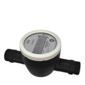
Kamstrup Water Metering Introduces a New Automated Metering Infrastructure System
ATLANTA, Dec. 6, 2017 - Kamstrup Water Metering is shaking up the water industry again, this time with their latest meter reading system. The new system, Kamstrup AMI, is an automated metering infrastructure that achieves a high reading performance with minimal hardware investment. Kamstrup AMI supplies hourly consumption data and analytics to water utilities, enabling water professionals to work more proactively with data. With data, water professionals can make informed decisions about bud...

DEWALT Launches Jobsite WiFi Access Points
TOWSON, MD – DEWALT® launches its Jobsite WiFi Access Points (DCT100) which are Made in the USA with global materials. First announced in May 2017 at ENR FutureTech, where leading construction teams learn about today's innovative applications of technology, DEWALT Jobsite WiFi Access Points are built to withstand tough construction site conditions. Reliable internet access is a necessity on residential and commercial construction sites large and small. DEWALT Jobsite WiFi Access Points utili...

The Next Generation of Water Industry Mixers
HUNTINGTON BEACH, Calif. - The need for quality mixing equipment isn't going to disappear any time soon, and Komax Systems has developed a Hi-Pass Static Mixer that addresses that need in a surprisingly efficient manner. Hi-Pass Static Mixer Solves Multiple Problems Fouling and plugging plague many industries but none more so than the water industry, and for companies and municipalities, that creates loss production and downtime due to cleaning and maintenance. The Komax Hi-Pass mixer is...
Datumate is Pleased to Announce a New Software Release
Datumate is pleased to announce a new software release for DatuSurvey™. The new release introduces new DTM capabilities and enhance Datumate's unique 2D vectorized measurements. In addition, the release contains significant linkage performance improvements; speed, scale and usability, designed to make user's workflow even more flawless, efficient and accurate. This release main features are: Faster Model Generation - Linkage process was significantly improved to yield higher success...

Hexagon Safety & Infrastructure Unveils Safe City Framework
Huntsville, Alabama – Hexagon Safety & Infrastructure unveiled its Safe City Framework at Smart City Expo World Congress, the leading international event for smart cities. Hexagon’s Safe City Framework offers flexibility to support solutions that advance capabilities, while being practical to implement within a city’s new or existing information and communications technology (ICT) infrastructure. Hexagon has been independently assessed as the global market leader for computer-aided dispatch (...

Trace Software International to Launch elec calc BIM
With 30 years of experience, Trace Software International, a leading company in the creation of design software solutions for the electrical engineering, is thrilled to announce that will launch elec calc™ BIM – a real game changer within the industry. Building Information Modelling (BIM) is here to stay, ready to disrupt old ways of doing things within the building industry. Previously, the design process in the construction industry - relied on multi-stage issuing of drawings - was characte...

Vectorworks 2018 Now Available in Spanish
Columbia, MD — Global design and BIM software developer Vectorworks, Inc. has released the Spanish version of its Vectorworks 2018 product line, which includes Vectorworks® Architect, Landmark, Spotlight, Designer and Fundamentals. New this year is Braceworks™, a structural load analysis add-on module targeted to designers and riggers working on temporary structures. The Spanish version follows the English version, released this past September, and joins the additional language versions of the p...

WinCan’s ESRI ArcGIS Integration Brings Enhanced GIS Capabilities to Sewer Inspection
PITTSBURGH, PA —When integrated with ESRI’s ArcGIS platform, WinCan VX sewer assessment software allows users to navigate and analyze inspection data using a rich GIS (geographic information system) interface. With it, users can click map features to link to section and defect information, or they can click a tabular record in an inspection to jump immediately to its mapped location. With this bidirectional link between GIS and WinCan, inspections can be pre-populated with data residing in GIS (...
Video: New Roundabout Under Construction at McIver and Old Florence Roads in Darlington County

Promenade at The Point

June Issue 2026
.jpg?width=225)