
DuroMaxx® SRPE From Contech® Approved By AREMA
Direct-Bury and Reline Applications Added to Manual for Railway Engineering West Chester, OH – Contech® Engineered Solutions announced that its DuroMaxx® steel reinforced polyethylene (SRPE) pipe available in diameters as large as 120” was recently approved by the American Railway Engineering and Maintenance-of-Way Association (AREMA) for both direct-bury and reline applications. DuroMaxx SRPE represents a revolution in pipe construction by combining the strength of 80 ksi steel with...

Manage Revit Warnings within the Autodesk BIM 360 Environment with New Service from Ideate Software
San Francisco, CA – Ideate Software, a veteran Autodesk® AEC Industry Partner, announces the launch of Ideate Dashboard for Autodesk® BIM 360®, a data visualization service that uses proprietary technology to provide information related to Revit warnings within the Autodesk BIM 360 environment. Autodesk’s BIM 360 software connects project teams and data from design through construction. Ideate Dashboard pulls design information from Revit models stored within BIM 360 projects in order to identif...

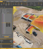
Bentley Systems Announces Availability of OpenGround Cloud to Increase the Value of Geotechnical Data
Going digital from ground to cloud with OpenGround Cloud offers advanced digital workflows for improved efficiency. (Image) New Cloud Service Assures Data Integrity for Geotechnical Information Management EXTON, Pa. – September 10, 2020 – Bentley Systems, Incorporated, a leading global provider of comprehensive software and digital twins services for advancing the design, construction, and operations of infrastructure, today announced the availability of OpenGround Cloud, a new c...

Esri Acquires nFrames to Enhance Its 3D Capabilities
Esri Will Offer World-Class 3D Surface Imaging Technology and Integrate into the ArcGIS Platform REDLANDS, Calif.—September 9, 2020—Esri, the global leader in location intelligence, today announced the acquisition of nFrames, a technology company that develops SURETM, an industry-leading imagery and lidar 3D surface reconstruction software. This will enable the fusion of imagery with 3D GIS, allowing nFrames and Esri users to seamlessly capture and analyze 3D data from aerial, drone, and...

HP Launches The World's Easiest Plotters for Architect, Engineer, Construction and Home Offices
News highlights: Simple to operate: Print multi-size projects automatically and send multiple files in one click with HP Click, all without compromising on speed.1 Fits your office and budget: Save space and make a statement with the world's smallest plotters2 designed to fit your office and style. Matches the way you work: Print your jobs and manage your print jobs from virtually anywhere, anytime with the HP Smart App. Meets your sustainability goals: First net carbon neu...
Golden Software Improves Surfer® File Handling for Faster Mapping
Create pie charts in Surfer showing proportions of attribute data for each feature (Above Image) GOLDEN, Colorado – Golden Software, a developer of affordable 2D and 3D scientific modeling packages, has made it faster and easier than ever to create maps in the latest version of its Surfer® gridding, contouring, and 3D surface mapping product. Additionally, Surfer users will find it is simpler to present, share and display their work with the software package. “We focused on improving...
Tech Companies ShapeDiver and Thornton Tomasetti’s Swarm Merge to Become the Largest Cloud-Based SaaS Platform for Accessing and Sharing Parametric Designs
Merger Drives Innovation in A/E/C Process and Product Design in All Industries, Occurs in Tandem with Investment by Thornton Tomasetti in ShapeDiver New York/Vienna – Technology companies ShapeDiver and Swarm, leaders in the development of cloud-based parametric computation and collaboration, announced plans to merge. Together, ShapeDiver and Swarm will offer the largest and most powerful cloud-native, Software as a Service (SaaS) platform for customizing workflows and accelerating the...
Virtual Surveyor Offers Enhanced Functionality in Free Version of Drone Surveying Software
AARSCHOT, Belgium, 8 September 2020 – In release 7.4, Virtual Surveyor has added new functionality to the free pricing level of its popular drone surveying software. The “Valley” plan of Virtual Surveyor now allows users to create engineering CAD models from drone orthophotos and/or LiDAR data sets. “Originally offered as a free viewing tool for imagery and elevation models captured by unmanned aerial vehicles (UAVs), our Valley software plan now enables surveyors to create topographic line s...
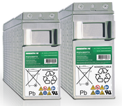
Exide Launches New Marathon FTX Battery for Telecom and Electric Utility Applications
GENNEVILLIERS, France - Exide Technologies (www.exide.com), a leading provider of stored electrical energy solutions, is expanding its product offer with the new GNB Marathon FTX range. The advanced AGM batteries are ideal for telecom and electric utility applications in good-grid environments, and offer exceptional reliability and performance at high temperatures. With its unique features, Marathon FTX is ideally suited to support 5G and progressive network densification. Performs at high te...
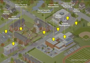
Zyter Introduces Smart Universities™
IoT Platform Supports a Digitally Connected Campus for a Personalized Student Experience and Efficient Facility Management ROCKVILLE, Md. – Zyter®, a leading digital health and IoT-enablement platform, announced today the availability of Zyter Smart Universities™, an Internet of Things (IoT) connectivity platform designed specifically for school campuses. Zyter Smart Universities transforms student life both on and off campus through smart classroom-based teaching, enhanced communic...
Video: Crashes Drop Measurably After Rural Road Safety Improvement Project on US 521 in Lancaster County

AdventHealth Weaverville Hospital

June Issue 2026
.jpg?width=225)