
Q-Free Launches New Website with Customer-Focused View to Solve Modern Traffic Mobility Challenges
Company creates new user experience focused on holistic solutions for smarter, safer, more sustainable transportation. OSLO, Norway – Q-Free (OSE: QFR), a global leader in mobility solutions for smart city infrastructure, today announced the launch of a new website to provide a more holistic, integrated and easy-to-understand customer experience that reflects the company’s overall global mission of solving modern traffic mobility challenges and delivering innovative smart city solutions. T...
Applanix Introduces Next Generation OEM Solution for Direct Georeferencing of Airborne Sensor Data
Hardware and Software Solution Provides Unparalleled Accuracy and Performance for Systems Integrators RICHMOND HILL, CANADA — Applanix, a Trimble Company (NASDAQ: TRMB), introduced today the Trimble® AP+ Air OEM solution for Direct Georeferencing of airborne sensor data. The solution enables users to accurately and efficiently produce maps and 3D models without the use of ground control points. The Trimble AP+ Air is a powerful solution for manned platforms yet small enough for use on Unmanned...
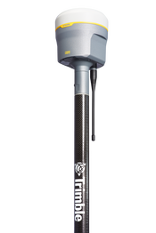
Trimble Announces the Next Evolution of its Flagship GNSS Solution
Trimble R12i GNSS Receiver Incorporates Robust Tilt Compensation to Increase Productivity for Land Surveyors SUNNYVALE, Calif.—Trimble (NASDAQ: TRMB) introduced today the Trimble® R12i GNSS receiver, the latest addition to its Global Navigation Satellite System (GNSS) portfolio. The Trimble R12i incorporates Inertial Measurement Unit (IMU)-based tilt compensation using Trimble TIP™ technology, which enables points to be measured or staked out while the survey rod is tilted, empowering land s...
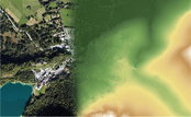
Elevate your performance with UltraMap 5.0
Graz, Austria: Vexcel Imaging announces the release of UltraMap version 5.0, the latest update of its all-in-one aerial photogrammetry software featuring comprehensive DTM generation and full integration of Ortho Production in UltraMap Studio. With the introduction of a completely new Digital Terrain Model (DTM) algorithm based on automatic semantic image segmentation and intelligent filtering, UltraMap 5.0 now generates comprehensive DSMs and DTMs for export at unprecedented quality. Additi...

Eos Positioning Systems announces compatibility of Eos Laser Mapping™ and Eos Locate™ with Esri ArcGIS Field Maps (beta)
The August 2020 release of Eos Tools Pro version 1.89 makes Eos Locate™ for ArcGIS (underground mapping) and Eos Laser Mapping immediately available for use with the Field Maps beta AUGUST 2020, MONTREAL, CANADA — Eos Positioning Systems (Eos), the Canadian manufacturer of the popular high-accuracy Arrow Series® GNSS receivers, has announced today the compatibility of two popular Eos field data-collection solutions with the Esri ArcGIS Field Maps beta. Eos Locate™ for ArcGIS is the world’s...

The PV software archelios™ Pro Silver: manage projects up to 100 kWp
Trace Software International is excited to announce the launch of the newest editions of archelios™ Pro. The software is an excellent tool for the feasibility and bankability study, simulation, 3D design, and sizing of any photovoltaic project. As the solar market becomes more and more complex and challenging, the company has launched a new PV software offering. Trace Software International has used its expertise to create four different PV tools’ proposals, archelios™ Pro Free, archelios™ Pr...
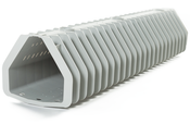
Xylem’s revolutionary Leopold Type 360 underdrain features innovative backwashing capability
New bolt down model increases efficiency RYE BROOK, N.Y., – Xylem now offers the Leopold Type 360 underdrain, a bolt down underdrain system for greenfield projects and water treatment filtration rehabilitation projects. The underdrain system has an innovative design concept where backwash water flows in a 360-degree pattern, increasing efficiency by up to 20%. “The industry challenged us to create an underdrain that combines efficiency, straightforward installation and individually se...

GNSS RTK rover with Visual Positioning increases safety, simplifies surveying
New GS18 I GNSS RTK rover with Visual Positioning can measure what you see (HEERBRUGG, SWITZERLAND, 18, August 2020) – Leica Geosystems, part of Hexagon, unveils the Leica GS18 I (announced by Hexagon yesterday), a versatile, GNSS RTK rover with Visual Positioning. The GS18 I allows users to capture points of interest from a distance and measure points from the images in the field or the office. Visual Positioning technology (sensor fusion combining GNSS, IMU and a camera) allows user...
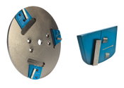
General Equipment Company Introduces MAGNETACH Line of Surface Preparation Accessories
OWATONNA, Minn. – General Equipment Company is rolling out its MAGNETACHÒ Tooling System, which is designed for use on single- and dual-head concrete grinding equipment with either left- or right-hand rotation. The new tooling system features convenient magnetic mounting and is compatible with surface grinders from General Equipment Company, as well as competitive products using Lavina/EDCO mounting configurations. The MAGNETACHÒ line includes the M-Series DIAM-A-TACHÔ diamond segment grinding s...
Q.E.D. MicroPurge MP25 Simplifies Low-Flow Groundwater Sampling
Purge stabilization flow cell ensures accuracy and consistency Dexter, MI – Q.E.D. Environmental Systems, Inc., a leading manufacturer of innovative environmental products and subsidiary of Graco Inc., highlights that its MicroPurgeÒ MP25 Purge Stabilization Flow Cell system makes consistent low-flow groundwater sampling easy and accurate. The associated PurgeScanÔ technology monitors purging parameters and performs stabilization automatically, reducing potential for error and inaccuraci...
Video: Crashes Drop Measurably After Rural Road Safety Improvement Project on US 521 in Lancaster County

AdventHealth Weaverville Hospital

June Issue 2026
.jpg?width=225)