
Datumate Announces Autodesk BIM 360 Integration for Improved Construction Site Visualization and Project Management
No-code integration empowers planning and construction teams with essential construction intelligence extracted in near real-time from survey-grade reality captures. YOKNEAM, Israel – Datumate, developer of the DatuBIM Construction Data Analytics platform, is pleased to announce today a productivity-enhancing integration with BIM 360®, a construction management software part of Autodesk Construction CloudTM. Seamless integration enables joint customers to stay informed about on-site construc...
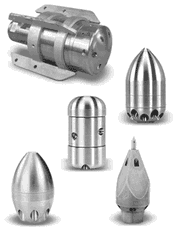
Tier 3 Nozzles Optimize Sewer Crew Efficiency and Profitability
Water conserving Tier 3 nozzles clean better and faster, enabling work crews to accomplish much more before having to refill the sewer truck water tank In sewer, storm and sanitary line cleaning, hose nozzles are an essential tool that directs pressurized water to clear out obstructions such as silt, sludge, grease, mineral buildup, and tree roots as part of required maintenance or to prepare pipes for re-lining. In this way, the nozzle is like a gun and water like bullets that must be...

GSSI Updates to StructureScan™ Mini XT GPR Kit and Palm XT Antenna
GSSI, the world’s leading manufacturer of ground penetrating radar (GPR) equipment, announces new updates to the StructureScan™ Mini XT all-in-one GPR concrete inspection system, including a software update and a newly designed survey wheel for the Palm XT Antenna. Rugged, compact, and flexible, the StructureScan Mini XT is ideal for locating rebar, conduits, post-tension cables, and voids. The Mini XT can help identify structural elements, including pan deck and concrete cover, and can also...

Siemens Energy and Bentley Systems Introduce Asset Performance Management Solution for Oil and Gas Operators
Solution combines Bentley Systems Inc.’s asset performance software capabilities with Siemens Energy’s oil and gas equipment expertise Enhances equipment uptime and reliability while reducing maintenance costs and safety risks Siemens Energy and Bentley Systems, Inc. (Bentley) have announced a joint solution that delivers intelligent analytics derived from domain experience to reduce operating expenditures associated with oil and gas assets. The new service, known as Asset Perform...

Renesas Releases 2nd Generation Digital Multiphase Controllers and Smart Power Stages for IoT Infrastructure System
Software Configurable Digital Multiphase Controller and Smart Power Stage Solutions Deliver up to 1000A+ Loads to Advanced CPUs, FPGAs, GPUs and AI ASICs TOKYO, Japan ― Renesas Electronics Corporation (TSE:6723), a premier supplier of advanced semiconductor solutions, today announced its 2nd generation of 15 new digital multiphase controllers and six smart power stages that support 10A up to 1000A+ digital computing loads for advanced CPUs, FPGAs, GPUs and artificial intelligence (AI) AS...
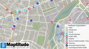
2020 Hospital & Healthcare Provider Organization Data as KML, GeoJSON, Shapefile
NEWTON, MASSACHUSETTS (USA) - Caliper is excited to announce the release of free updated healthcare map layers. We are providing over 6 million medical and healthcare provider points-of-interest. These locations can be analyzed with the tools and data already included with Maptitude, such as counts by health insurance coverage type. The provision of the entire healthcare landscape in a mapping format is unprecedented. Accountable care and better access to electronic health records are driving...
Innoviz Technologies Introduces Its Next Generation, InnovizTwo, Which Will Accelerate the Industry Towards Autonomous Driving, Enabling Safe Mobility To All
Major cost reduction of Innoviz’s new high-end LiDAR will allow car manufacturers to offer safe L2+ vehicles with a path to L3 with software updates ROSH HA’AYIN, Israel – Innoviz Technologies, a leading provider of high-performance, solid-state LiDAR sensors and perception software, is launching a next-generation sensor to its product line – the InnovizTwo. The new high-performance automotive-grade LiDAR sensor offers a fully featured solution for all levels of autonomous driving at a drama...
Leica Geosystems continues airborne hybrid road map with latest modular sensor offering
Leica TerrainMapper-2 integrates LiDAR and imaging for regional mapping projects and offers simple upgrade path to oblique imaging system.(aove image) Leica TerrainMapper-2 integrates LiDAR and imaging for regional mapping projects and offers simple upgrade path to oblique imaging system (HEERBRUGG, Switzerland) – Leica Geosystems, part of Hexagon, today introduced the Leica TerrainMapper-2, the latest solution in the company’s hybrid sensor road map that integrates LiDAR and image c...
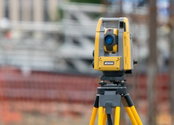
New Topcon robotic total station system built for versatile survey and construction workflow performance
LIVERMORE, Calif. – October 13, 2020 – Topcon Positioning Group announces new flagship GT Series robotic total stations are available for survey, construction, and machine control applications. The GT-1200 and GT-600 total stations are available in multiple accuracy levels. The new total stations are part of a full workflow solution, including a new field computer, a full-version update to Topcon field and office software, as well as GNSS receivers. The system is designed to work in sync for...

Nemetschek Group Paves the Way for Continuous Model Workflows in the Construction Lifecycle
New solution to automatically create analysis model, from architectural or structural model Open BIM workflows now integrate structural engineers More efficient cross-discipline collaboration Munich – In conjunction with the release of Allplan 2021, the Nemetschek Group is reinforcing its solution portfolio for increased collaboration in the construction lifecycle. With SCIA AutoConverter, in a limited version part of Allplan 2021, structural engineers can fully participate in the...
Video: Crashes Drop Measurably After Rural Road Safety Improvement Project on US 521 in Lancaster County

AdventHealth Weaverville Hospital

June Issue 2026
.jpg?width=225)