
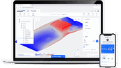
Pix4D launches new ground image capture app for 3D modeling with the iPad Pro and iPhone 12 Pro
Lausanne, Switzerland, [November 10, 2020]: Pix4D, the photogrammetry industry leader, announces today the release of a new app product for ground images acquisition: Pix4Dcatch. Pix4Dcatch empowers users to easily create ground-based 3D models using an iOS mobile device. No need to be an expert, the user simply scans the area of interest with Pix4Dcatch. The app records pictures along with GPS positions. Compatible with recent iOS devices, but optimized for the newest iPad Pro and iPhone 12...
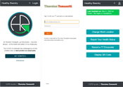
Thornton Tomasetti releases 'Healthy Reentry' free software to aid safe office return
Open Source App Provides Customizable Health Reporting And Contract Tracing Capabilities New York, NY – Thornton Tomasetti has open sourced its proprietary Healthy Reentry (HR) application for health monitoring and contract tracing. Designed to facilitate the safe return of employees to the workplace, the web-based solution can be customized to meet the needs of large and small companies while protecting the privacy of staff. Healthy Reentry enables employees to record their health s...

Enscape Releases Version 2.9 With Vectorworks 2021 Integration
Milestone release adds Vectorworks to Enscape’s list of fully supported 3D modeling programs Columbia, MD (November 5, 2020)—Enscape GmbH, the leading provider of real-time rendering and virtual reality technology for the global architecture, engineering and construction (AEC) industry, has launched Enscape 2.9. This release supports Vectorworks 2021 from global design and BIM software provider Vectorworks, Inc. and allows architects, landscape design professionals and entertainment desi...

Leica Geosystems innovates automated total station portfolio
Range of automated total stations now with new integrated functionalities increase productivity in any environment (HEERBRUGG, Switzerland ) – Leica Geosystems, part of Hexagon, has enhanced the entire automated total stations portfolio in 2020. Starting with the new Leica Nova MS60 MultiStation and TS60 total station, now the new Leica TS16 and TS13 total stations and the new TM60 monitoring total station are introduced. Leica Geosystems’ automated total stations range is designed t...

Polygon Announces PolySlide® Composite Tubing for Pneumatic and Hydraulic Cylinders
Ideal for replacing metallic material in a variety of cylinder applications Walkerton, IN – Polygon Composites Technology, a leading manufacturer of composite tubing solutions for bearings, dielectric applications, surgical devices and more, announces PolySlide® Composite Tubing for pneumatic and hydraulic cylinders. PolySlide tubing replaces metallic material in a variety of cylinder applications. Supplied as a cylinder tube ready for customer assembly, or as fully engineered cylinde...
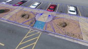
Virtual Surveyor Introduces Curb & Gutter Mapping in New Version of Drone Surveying Software
AARSCHOT, Belgium – Virtual Surveyor has introduced Curb & Gutter mapping functionality in Version 7.6 of its popular drone surveying software. The new capability enables surveyors to create a lightweight CAD model of curbs and gutters along the edges of streets and parking lots from standard orthophotos and elevation models captured by unmanned aerial vehicles (UAVs), or drones. “Accurately mapping the height of curbs and geometry of gutters is critical for modeling the flow of water away fr...
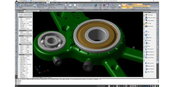
IntelliCAD Technology Consortium Announces Release of IntelliCAD® 10.0a
Portland, OR, USA — The IntelliCAD Technology Consortium (ITC) today announced the release of IntelliCAD 10.0a. IntelliCAD 10.0a is a maintenance release for version 10.0 that was previously issued on July 30, 2020. IntelliCAD maintenance releases concentrate on fixes, but IntelliCAD 10.0a includes minor new features: choose the color of print stamps, determine whether print stamps print upside down, and use the new Show Palettes and Hide Palettes commands. Also included for multiline text are...
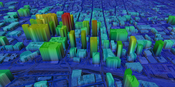
UP42 Partners with Intermap to Bring High-Resolution Elevation Data to UP42’s Geospatial Marketplace
NEXTMap Digital Surface Model (DSM) BERLIN, Germany – UP42 is pleased to announce that the NEXTMap Elevation Data Suite from Intermap Technologies is now offered on the UP42 developer platform for Earth observation data and analytics. The NEXTMap 3D elevation products are available as Digital Surface Models (DSM) and Digital Terrain Models (DTM) at one-, five-, and 10-meter resolution. The addition of NEXTMap datasets to the UP42 marketplace enables users to build even more powerful...
OnScale Introduces OnScale Solve™: The World’s First Cloud Engineering Simulation Platform
Silicon Valley, CA – OnScale today announced the release of the OnScale Solve, the web-based cloud engineering simulation platform bringing to engineers powerful multiphysics solvers and scalable cloud supercomputer resources. “OnScale Solve gives engineers, designers, and analysts access to the powerful cloud-native engineering simulation tools and cloud supercomputer resources they need to innovate, solve complex problems, and efficiently work from any location and device,” says Ian Campbel...
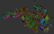
GeoSLAM Completes Spook-Tacular Scanning of Californian Landmark
The team at geospatial 3D mapping specialist GeoSLAM has produced a digital twin of one of the world’s most haunted mansions, The Winchester Mystery House, using the newly-launched ZEB Go. It may be hard to believe the feat of scanning this vast architectural landmark, built in 1886. The site, located in the City of San José, spans 4.5 acres and the four-story mansion covers 24,000 square feet, featuring some 160 rooms, as well as 40 staircases, basements and a myriad of passages, corridors a...
Video: Crashes Drop Measurably After Rural Road Safety Improvement Project on US 521 in Lancaster County

AdventHealth Weaverville Hospital

June Issue 2026
.jpg?width=225)