
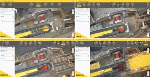
Construction professionals understand that daily visualization of a jobsite helps minimize construction delays, prevent clashes between as-built and as-design, eliminate the need for rework, facilitate stakeholder communication and align schedules. But how…

Going Digital: Bentley Systems Advances Reality Modeling to Extend the Scope of Engineering and Surveying Value
A 3D engineering-ready reality mesh created in ContextCapture comparing (left to right) photogrammetry, LiDAR, and a hybrid input. (Image courtesy of…
Aconex for Contractors Tackles Crisis in Construction Project Performance
SAN FRANCISCO, California, April 5, 2017 – Aconex Limited (ASX: ACX), provider of the #1 global platform connecting teams on construction and engineering…

New Economical Environmentally Safe Corrosion Inhibitor For Multiple Applications- Powerful Concentrate Provides Maximum Effect In Low Dosages
VpCI®-649 BD is a unique, concentrated liquid formulation that protects ferrous and non-ferrous metals from corrosive solutions. In addition, this product is designed to provide long-term protection in fresh water, steam and glycol closed loop systems. VpCI®-649…
Aconex Launches Connected Cost
SAN FRANCISCO, California, April 5, 2017 – Aconex Limited (ASX: ACX), the #1 cloud platform connecting teams on the world’s largest construction and engineering projects, today launched Aconex Connected Cost, an integrated solution that brings together…
SBG Systems to Unveil Qinertia, the Next Generation INS/GNSS Post-Processing Software at Ocean Business
Rueil-Malmaison, France, April 3rd 2017 - SBG Systems takes a major step in the surveying industry by unveiling Qinertia, its in-house post-processing software at the Ocean Business show (UK). After the survey, this full-feature software gives access to offline…
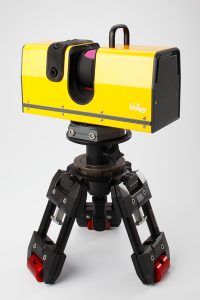
New Surphaser Model 400 with Scan Range up to 300 m and Sub-Millimeter Noise up to 160 m
Basis Software, Inc., is pleased to introduce the Surphaser Model 400 laser scanner. The new model builds on Surphaser product line of compact light weight scanners. The Surphaser 400 will be presented at the SPAR 3D Expo and Conference, Houston, Texas. Model…

World First in Computer Aided Engineering (CAE) New Tool from EDEM Brings Discrete Element Modelling to Every Engineer
EDEM®, the market leader in Discrete Element Method (DEM) technology, is changing the face of Computer Aided Engineering (CAE) with a revolutionary new software that will make bulk material simulation accessible to all engineers using Finite Element Analysis…
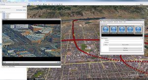
Remote GeoSystems Releases All-New LineVision Google Earth Extension for Geotagged Video Playback, Analysis, Collaboration and Reporting Using Google Earth & Other GIS
FORT COLLINS, Colorado – Remote GeoSystems, Inc. is pleased to announce the release and availability of the all new LineVision™ Google Earth Extension – commercial software for UAV, airborne & terrestrial mobile inspection and survey projects requiring…
Trimble Incorporates Galileo Support in New Version of its GNSS Infrastructure Management Software
SUNNYVALE, Calif. —Trimble (NASDAQ: TRMB) introduced today version 3.10 of its Trimble® Pivot™ Platform software, a modular solution for real-time GNSS infrastructure management, ranging from a single-base GNSS Continuously Operating Reference Station…
