

WASHINGTON, D.C. (Feb. 13, 2018) – BuildSteel, a partnership of steel and construction industry organizations, announced the release of “Strength in the Face of Disaster: How Cold-Formed Steel Framing Keeps Buildings Safe,” a free e-book exploring the…

New FARO Design ScanArm 2.0 Improves Product Design Workflow
Lake Mary, FL - FARO® (NASDAQ:FARO), the world’s most trusted source for 3D measurement and imaging solutions for factory metrology, product design,…
NavVis Sets New Standard in SLAM Precision
MUNICH, Germany – NavVis, a global leader in mobile indoor mapping, visualization, and navigation, announces new mapping software that significantly…

Pettibone Introduces Next Gen T944X Telehandler With Industry-Exclusive Traversing Boom
BARAGA, Mich. — The new Pettibone Traverse T944X is the industry’s only new telehandler with an extendable, traversing boom that moves loads by traveling horizontally. Up to 70 inches of horizontal boom transfer allows users to precisely and safely place…

Leica Geosystems Introduces Latest in Linear Mode LiDAR
Heerbrugg, Switzerland – Leica Geosystems, industry leader in measurement technology, announced today the launch of TerrainMapper, its next generation linear mode LiDAR system. As part of the RealTerrain airborne LiDAR mapping solution, the new sensor builds…
Trimble Announces New MX9 Mobile Mapping System for Surveying, Engineering and Geospatial Professionals
SUNNYVALE, Calif —Trimble (NASDAQ: TRMB) announced today the release of the Trimble® MX9 mobile mapping solution. The Trimble MX9 combines a vehicle-mounted mobile lidar system, multi-camera imaging and field software for efficient, precise and high-volume…

Leica Geosystems Multipurpose Mobile Mapping Platform Increases Smart City Applications
Heerbrugg, Switzerland – Leica Geosystems, industry leader of measurement technology, released today the new Leica Pegasus:Two Ultimate, an upgrade to its current mobile mapping platform bringing higher quality digital reality capture to the market. …

HP Launches the World’s Most Secure Large Format Printers for GIS mapping
PALO ALTO, Calif. — HP Inc. today introduced HP DesignJet T1700 printers, next-generation 44-inch solutions for CAD and geographic information system (GIS) workgroups to produce highly accurate documents and maps with powerful processing and a new…

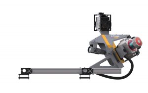
Envirosight Releases New Quickview airHD+ Sewer Assessment Camera
RANDOLPH, NJ— Zoom assessment cameras are used to help determine sewer condition, and the Quickview brand revolutionized the sewer inspection industry by providing rapid, affordable visual assessment capabilities in sewer lines, stormwater lines, catch basins…
Woolpert Updates SmartView Connect to Publish Mapping Data at Unprecedented Speeds
DAYTON, Ohio — Woolpert has launched the SmartView Connect (SVC) Version 5, a streamlined quality assurance/quality control (QA/QC) tracking application to review preliminary imagery, elevation and remote sensing data sets. SVC is an open geospatial…
