
Golden Software Expands 3D Subsurface Visualization Capabilities in Latest Surfer® Surface Mapping Package
Golden Surfer ClippingPane: Peer inside your model using clipping planes.(Image)
GOLDEN, Colorado, 13 September 2023 – Golden Software continues to expand the 3D subsurface data visualization functionality in its Surfer surface mapping package. The newest Surfer version – available today – gives users a broader selection of easy-to-apply tools to grid, map, and view their well, drillhole, and borehole data sets.
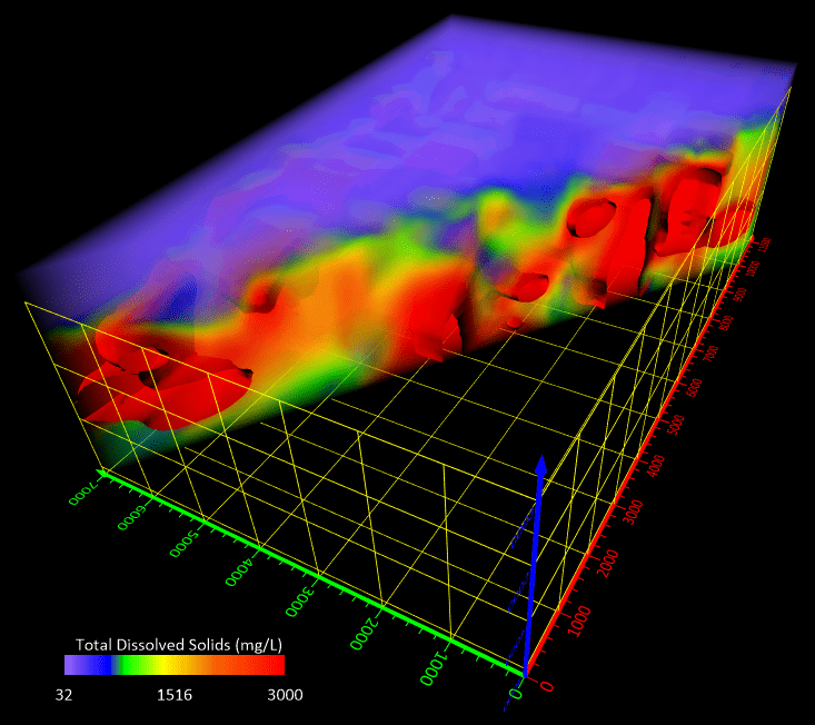
The latest Surfer builds on the powerful true 3D gridding and visualization capabilities introduced in the software package earlier this year when Golden Software added the ability to model a fourth “C” variable, such as contaminant or chemical concentration, along with traditional X, Y, Z values.
“Surfer is a much more powerful subsurface mapping package, providing users with more capabilities to analyze their 3D data sets and extract useful information from them,” said Kari Dickenson, Surfer Product Manager. “This functionality assists environmental engineers, hydrologists, geophysicists, and geologists to better understand the areas around their wells and drillholes.”
Long known as the geoscience profession’s most powerful 3D surface mapping software, Surfer has been relied upon for the past 40 years to easily visualize, analyze, and interpret complex data sets. With fast and powerful contouring algorithms, the package is used by more than 100,000 professionals worldwide, many involved in environmental services, engineering consulting, resource exploration, and geospatial projects.
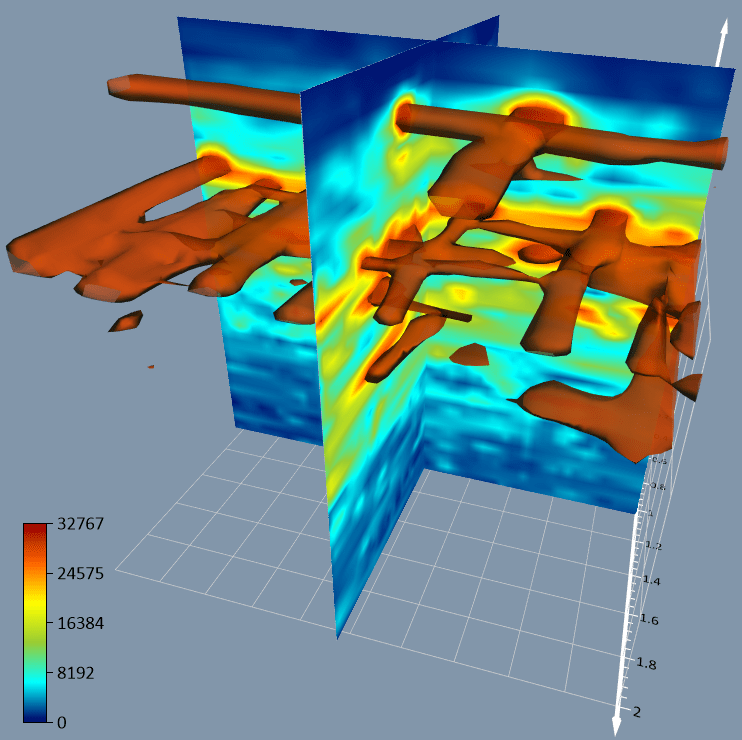
Create a slice through your data on the fly and use a slide bar to interactively move the slice through your model.
The new version of Surfer includes several enhancements:
Image Slice Visualization – Users can create a slice at any angle through a 3D volume and view the slice as a colorful image. This is an ideal way to view a subsurface or terrain cross section to visualize how the “C” concentration changes through the 3D volume.
Image Clipping – For any 3D volume, slice, or isosurface, users can clip the visualization at any angle, elevation value, or location point. This tool lets users define the precise values of the clipping plane and remove data in the display to focus on the most important information.
Enhanced 3D PDF Export – 3D views exported from Surfer as a 3D PDF are now organized exactly the same when opened in Adobe software, containing groups in the model tree for axes, surfaces, grid volumes, and other elements, which users can easily turn on and off.
True Vertical Depth Calculation – Determining the accurate vertical depth of a drillhole (well, borehole, etc.) is challenging when the path curves, deviates from vertical, or is at an angle. Surfer now gives users the choice between five calculation methods to determine true vertical depth from measured depth, regardless of the complexity of the drillhole path.
Save Data from Drillhole Manager – A huge timesaver for subsurface mapping and data sharing, drillhole data can be saved directly from the Drillhole Manager. Users have the option of saving the data in many file formats, including ASCII text and Excel. Users can save data tables as they are, to be shared with colleagues or other projects, or can save a data table of XYZC information with true vertical depth. An XYZC data file can be used directly in Surfer for 3D gridding which can then be displayed in the 3D View as a volume render or other 3D visualization.
Surfer Beta Available
As is the tradition, Golden Software has released a Beta version of Surfer simultaneously with the new version to give customers a chance to try out new features while they are still in development. Users may find the Beta version by clicking File | Online from within Surfer.
“The new Beta functions continue to build on the subsurface visualization tools, giving users more options and greater flexibility,” said Dickenson. “We have also focused on enhancing overall usability.”
Here are the new Beta features available now in the next Surfer release:
- Block Rendering – Users can now render 3D grids as a series of blocks, which can be colorized by a select variable. This is an easy way to calculate and visualize volumes, such as contaminants in a plume.
- Enhanced Image Import – Images of cross sections, profiles, and other features can be imported directly into 3D View and oriented in any direction or angle. This makes it easy to create fence diagrams from multiple imported images.
- Direct Drillhole Gridding – Users can now import XYZC drillhole data and grid it without saving in the Drillhole Manager. Although the option to save the data in various formats still exists, the direct importing and gridding function saves significant time.
- Assigning ‘NoData’ to 3D Grid – To isolate certain features in the 3D grid, users can assign NoData to portions of the grid with a variety of methods: convex hull of the data points, an alpha shape of the data set, a polygon boundary, or above/below a 2D grid surface. This allows users to eliminate unwanted data in a 3D grid outside of field boundaries, well locations, or above (or below) specific surfaces, such as a water table, topography, or lithologic layer.
- Retain Drawing Properties – When users import base vector layers, they often change the colors and symbols for features such as roads, rivers, and cities. Now these drawing properties can be retained when the base layers are reloaded.
- Save All – Users can save all open documents and their changes with a single click on Save All, a feature that avoids accidental loss of data when closing multiple open projects at once.
About Golden Software
Founded in 1983, Golden Software is a leading developer of affordable scientific graphics software. Its customer base includes over 100,000 professionals involved in environmental services, engineering consulting, resource exploration and extraction, applied science, business, education, and government in nearly 190 countries and territories. Golden Software offers two products: Surfer® for gridding, contouring and 3D surface mapping and Grapher™ for 2D and 3D graphing.
For additional information, visit www.GoldenSoftware.com or call 1-303-279-1021.
