
Even Pump Stations Get the Blues
3D Visual Presentation Pushes Wastewater Project Forward
The retrofit of a wet-well/dry-well pump station into a submersible pump station isn’t normally the type of project that requires a glossy 3D model as part of design work—most firms would reserve that for more glamorous, higher-profile infrastructure such as a railway station or a new bridge. But for Wright-Pierce, a nine-office, employee-owned consulting firm based in New England and Florida, it made sense.
“Wright-Pierce is well-established in New England, but here in Florida we’re a new entity,” explains Senior Civil Technician Christopher Hinkley. “We really feel we need to invest in compelling images right now, even for relatively mundane projects like the pump station retrofit. It’s a way to stand out, differentiate ourselves from competitors and get our proposals accepted. It’s a new way of thinking for us, and it’s working.”
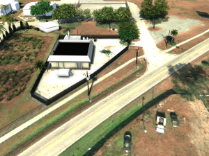
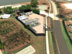
The $6.8 million project in question is in an Orlando neighborhood, and the model was prepared to win the project and show the client alternative layouts for consideration. It also was used to facilitate discussions with the city planning department about landscaping, fencing and architectural considerations.
“One of the goals of this visualization was to model and show alternatives quickly—for example, we wanted the planning department to see several proposed shrub layouts,” says Hinkley. “InfraWorks proved to be good for this.”
Hinkley began work on the visualization by importing record drawings into Autodesk’s Civil 3D. “Then, to make it pop, we brought it into (Autodesk’s) InfraWorks, and also brought in some work that had been done in (Autodesk’s) Revit.” To coordinate work done in Civil 3D, Revit, InfraWorks and Navisworks, Hinkley used the shared reference point capability in Civil 3D to export known points and elevations from Civil 3D and import them into Autodesk Revit to establish a “Shared Coordinate System.” This enables the collaboration of exported RVT, DWG and NWC files back to AutoCAD Civil 3D and to coordinate models in Autodesk Navisworks.
“Using the reference point tool was something of a test when we were working on the pump station retrofit project—we had been looking for ways to make Civil 3D and Revit work better together,” says Hinkley. “It really worked well, and now it’s becoming common practice in our office.”
This illustrates another advantage of using all the design tools available when developing presentation models for smaller projects—since the scale of the project is relatively modest, and the stakes are small, it’s a good opportunity to try out new techniques and tools which may eventually be incorporated smoothly into larger, more challenging projects.
The InfraWorks model was a success. “It was very well received, and the planning committee seemed to be engaged,” notes Hinkley. “They asked us to show the station from different angles so they could get a feel for how the finished project would look, and we were even able to add or change trees or shrubs at their request, to show alternatives. It was a helpful discussion on both sides, and I assume we’ll be doing more of these models for meetings.”
And it wasn’t just the planning committee that saw added value from the presentation work. “Internally, we loved it! It got everyone on the same page, helped us review alternatives quickly and pushed design work forward,” adds Hinkley.
Small Projects Can Be Treated Like Big Projects
Founded in 1996 by a small team of former Oregon Department of Transportation (ODOT) engineers, Oregon Bridge Engineering Company (OBEC) is a consulting firm that sticks close to its roots, focusing primarily on federal-, state- and municipal-funded transportation infrastructure projects in the Pacific Northwest.
“We’re one of the ‘go to’ firms for ODOT and other state agencies, but local agencies and communities are also one of our strengths,” says OBEC CAD Manager Eric DeLeon. “One of my responsibilities here is to apply the expertise we develop on really big projects, like the $204 million Willamette River Bridge Replacement in Eugene [www.obec.com/bridge/i5-willamette-river-bridge.html] across the board to all our projects. Sometimes that means we’re giving local clients something they’re not used to, in a good way; we’re leveraging design expertise to create value for them and a better market position for us.”
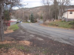
An example is the Stevens Road-East Main St. to Robert Trent Jones Blvd. project, in the city of Eagle Point, Ore., population 8,500. Given the scale of some OBEC roadway projects, this is rather small—a straightforward widening and resurfacing that adds sidewalks, curb and gutter, bike lanes, improved drainage, and left-turn lanes to a locally important stretch of road near an elementary school and trailer park. To present their design vision and win the project, OBEC went “all out” with a 3D composite rendering of its proposal. This level of investment normally may be reserved for larger projects in more-sensitive areas, but, according to DeLeon, “We know how to do this type of presentation well and quickly, and we’ve learned that composite renderings are a solution that helps affected community members really understand the impacts of a proposed design by seeing how it actually looks when projected on their own neighborhoods.”

In this case, DeLeon imported preliminary 3D design work into Autodesk’s InfraWorks and used InfraWorks to quickly model site features. He then asked the firm’s graphic designer to use photographs of the site as overlays on his modeling work to create realistically rendered 3D views.
According to DeLeon, the highly realistic representations were “used as a communication tool, particularly in meetings with the trailer-park owner and residents, who were concerned about the look of the new road and the impacts of new retaining walls. We used it in project interviews and as part of our proposal to owners to convey our design approach and why we thought this was the best way to upgrade this section of roadway. Several times we heard that our visualizations were ‘awesome.’”
And it worked; OBEC won this project, and trailer-park residents were reassured that the impacts of the roadway upgrade would be reasonable.
This is not the first time OBEC has used composite renderings during the proposal process, and they’re not the only consulting firm putting in this type of effort. “We’ve done this before, on a handful of similarly scaled projects, and in those cases some competitors were also using good 3D visualizations,” says DeLeon. “And it’s not as if we won all of those, or even that 3D presentations always equal a win.
“It still comes down to having the best design approach,” he notes. “But it’s always true that good presentations are needed to communicate good design, so we look to do these routinely. Put another way, we agree wholeheartedly with the idea that small projects can be treated like big projects.”
Todd Danielson
Todd Danielson has been in trade technology media for more than 20 years, now the editorial director for V1 Media and all of its publications: Informed Infrastructure, Earth Imaging Journal, Sensors & Systems and Asian Surveying & Mapping.
Video: New Roundabout Under Construction at McIver and Old Florence Roads in Darlington County

Bridge Replacement at Amsterdam Centraal Station

June Issue 2026
.jpg?width=225)