

New functionalities in the updated version of IQMaps improve the visualisation of radar data (Pisa, Italy) IDS GeoRadar, part of Hexagon, today announces that it has enhanced IQMaps, its post-processing software application for advanced GPR…
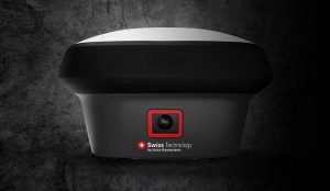
GNSS RTK rover with Visual Positioning increases safety, simplifies surveying
New GS18 I GNSS RTK rover with Visual Positioning can measure what you see (HEERBRUGG, SWITZERLAND, 18, August 2020) – Leica Geosystems, part…

TerraGo Adds Topcon GNSS Receiver Integration to Mobile Data Collection Platforms
TerraGo, a pioneer of geospatial collaboration and enterprise mobility software, announced today the integration with Topcon’s Sokkia high-accuracy…
High-Accuracy, On-Demand Positioning-as-a-Service Now Available with Trimble Catalyst
SUNNYVALE, Calif.- Trimble (NASDAQ: TRMB) announced today that Trimble® Catalyst™ software-defined Global Navigation Satellite System (GNSS) receiver for Android devices is now available through Trimble's global distribution network. Customers…

Seiler Instrument Chooses TerraGo Magic to Build its Mobile GNSS App Platform
TerraGo is pleased to announce a new partnership with Seiler Instrument, a leading provider of surveying software and instruments. Seiler is utilizing TerraGo Magic to build an advanced GNSS collaboration app platform to provide its customers with a complete…

Asteri Navigation Launches X-Series of Wearable GNSS Receivers at 2016 Autodesk University
Asteri Navigation will introduce a new line of rugged, compact and fully integrated GNSS receivers on November 15 at the 2016 Autodesk University in Las Vegas. Designed for geospatial field data collection and inspection applications that require high accuracy…

Septentrio Supplies GNSS Reference Stations to Oregon Department of Transportation
TORRANCE, Calif. – The Oregon Department of Transportation (ODOT) Geometronics Unit is deploying 19 Septentrio PolaRx5 GNSS reference stations to augment and update its statewide real-time GNSS network. The Septentrio receivers are being integrated…
