/ Category / drone

Esri Announces New Security Enhancements through Integration of US Government-Approved Drone and Cloud Deployment to the European Union

October 7, 2020 - in News, Products, Technology

Global Users Facing Restrictions on Drone Hardware or Drone Data Now Have a Complete, End-to-End Solution for Planning, Executing, and Processing Data   REDLANDS, Calif.—Esri, the global leader in location intelligence, today announced two major capabilities…

What Happened at LiDAR for Drone 2017 – YellowScan User Conference

July 24, 2017 - in Event Coverage, Events

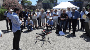
LiDAR for Drone 2017 – YellowScan International User Conference was held on the 29th and 30th of June, in the Château de Flaugergues, Montpellier.…

DOT and FAA Finalize Rules for Small Unmanned Aircraft Systems

June 21, 2016 - in Corporate, Surveying/Mapping

WASHINGTON – Today, the Department of Transportation’s Federal Aviation Administration has finalized the first operational rules for routine commercial…

Aerial Infrastructure Insight

April 3, 2016 - in Feature, Featured

Using Unmanned Aircraft for Land Development and Bridge Inspection Unmanned aircraft systems (UASs), often referred to as drones, have been making inroads into traditional surveying applications for the last decade. Much of this advancement has occurred outside…

Woolpert Deploys UAS to Collect Imagery for Rural Roads Project

March 25, 2016 - in Corporate, Roads, Surveying/Mapping

Woolpert has been hired by Michigan Tech Research Institute (MTRI) to collect imagery via unmanned aerial system (UAS), or drone, of haul roads throughout the Midwest. This project, “Characterization of Unpaved Road Conditions Through the Use of Remote Sensing,”…

Korea’s Wall-climbing Drone Aids Infrastructure Inspection

March 18, 2016 - in Products, Sensors, Surveying/Mapping

A new wall-climbing drone can approach any type of structure by flying and sticking to the target and utitlizing a pose change and perching mechanism. The integrity of large structures like bridges, high-rise buildings, wind turbines, and large aircrafts is…

3DR Announces Site Scan Aerial Analytics Platform for Data Collection and Cloud Analysis

March 7, 2016 - in Corporate, Design/Engineering, Sensors

Berkeley, Calif., March 7, 2016—3DR today announces the release of Site Scan, an aerial analytics platform that enables customers to safely, quickly and easily inspect, survey and scan work sites with the Solo smart drone and seamlessly deliver that data…

Kespry and Nvidia Demonstrate Deep Learning for Commercial Autonomous Drones

November 12, 2015 - in Corporate, Design/Engineering, Sensors

MENLO PARK, Calif., Nov. 10, 2015—Kespry , a commercial drone system company, today demonstrated a prototype drone that uses NVIDIA artificial intelligence technology to recognize objects. The state-of-the-art Kespry prototype uses an NVIDIA Jetson TX1…

R.A. Smith National Given Green Light from FAA on Commercial Use of Unmanned Aircraft System (UAS)

October 7, 2015 - in Corporate, Surveying/Mapping

R.A. Smith National — a nationwide, multi-disciplined civil and structural engineering and surveying firm — headquartered in Brookfield, Wis., has been granted a Section 333 Exemption from the Federal Aviation Administration (FAA). This exemption, granted…

AibotX6 Version 2 Uses High Precision GNSS

September 30, 2015 - in Corporate, Sensors, Surveying/Mapping

Kassel/Stuttgart, Germany, Sept. 30, 2015 – Aibotix GmbH has presented a new solution for high-precision surveying with Version 2 of its tried and tested hexacopter AibotX6: High Precision GNSS. After the successful conclusion of collaboration between the…