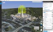
Topcon Announces Next Generation Flight Planning Software
LIVERMORE, Calif., U.S./ CAPELLE A/D IJSSEL, the Netherlands – Topcon Positioning Group announces the next generation flight planning system for its rotary-wing aerial UAV offering — Intel® Mission Control Software. The new software is designed to facilitate automated flight planning, managing missions, and data handling for the Intel® Falcon™ 8+ Drone – Topcon®Edition and its available payload options. The software is designed to increase accuracy with advanced mapping features that allow op...

Topcon Announces Advanced Bentley Integration for Aerial Photogrammetry Processing
LIVERMORE, Calif. & CAPELLE A/D IJSSEL, Netherlands - Topcon Positioning Group announces new cloud-based photogrammetry processing powered by Bentley ContextCapture to its MAGNET Collage Web web-based service for publication, sharing, and analysis of reality capture data. The integration allows MAGNET Collage Web users who share and collaborate with scanning and mesh datasets to now process and add UAV photos directly to the MAGNET Collage 3D environment. The built-in Bentley ContextCapture C...
New Complete Ecosystem Created with Smallest Imaging Laser Scanner, Award-Winning Mobile-Device App
(HEERBRUGG, SWITZERLAND, 22 MAY 2019) - Leica Geosystems, part of Hexagon, today announced the Leica Cyclone FIELD 360 laser scanning mobile-device app now works in conjunction with the Leica BLK360 imaging laser scanner to create a laser scanning ecosystem where captured data is streamlined for registration and publication. With the innovative combination of laser scanner and software, users can view, quality control and prepare data directly in the field using a tablet computer. Downstream,...

Trimble Releases Next-Generation Integrated Smartphone and GIS Data Collector
SUNNYVALE, Calif.— Trimble (NASDAQ: TRMB) introduced today the Trimble® TDC600 handheld, an ultra-rugged, all-in-one smartphone and Global Navigation Satellite System (GNSS) data collector for Geographic Information System (GIS) and field inspection applications. The next-generation smartphone data collector boasts an Android™ 8.0 operating system, bright sunlight-readable 6-inch display, powerful 2.2 GHz processor, 4 GB memory and an enhanced capacity all-day battery. Built for GIS users in...

Delair Introduces Open Payload Version of Long-Range UAV to Enable Custom Configuration of Sensing Capabilities
TOULOUSE, France – Delair, a leading supplier of commercial drone solutions, today introduced a new model of its popular long-range UAV, the Delair DT26, which offers an easy-to-integrate architecture for adding user-specified sensors and other payloads to the platform. The Delair DT26 Open Payload model features a removable container which can hold up to 3 Kg of extra payload and be connected to a power supply of up to 140W. It allows drone users to quickly add specialized sensors for specifi...
Gaist’s Mapping Solution Could Boost Efficiency for Utilities Market by 10 Per Cent at 0.01% of Project Cost
London, UK – Utilities companies looking to cut the cost and time of their construction works today have a new solution available to them as Gaist revealed its unique infrastructure digital twin has the potential to increase efficiency output by 10 per cent at 0.01 per cent of the project cost. Showcasing its innovative mapping solutions to the utilities market for the first time at this week’s Utility Week Live, Gaist covers over 341,500 kilometres of the UK’s roads and pathways with more th...

IMAGINiT Clarity 2020 Improves Revit Project Management
BALTIMORE, MD — IMAGINiT Technologies’ latest release of the Clarity 2020 suite of products optimizes the BIM team’s efficiency by automating manual work, unlocking insights for easy analysis and seamless sharing of Autodesk Revit data across the entire team of building owners and project partners. “Every new feature and enhancement in Clarity 2020 is designed to deliver insights to the right people faster, facilitating a smarter BIM team that works more efficiently,” says Bill Zavadil, chie...
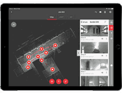
Topcon Introduces Real-Time Reality Capture Solution
LIVERMORE, Calif. – Topcon Positioning Group announces its new real-time reality capture solution for building construction verification will be demonstrated at the SPAR 3D Expo and Conference — the GTL-1000. The new real-time verification solution includes a compact scanner integrated with a fully featured robotic total station. Combined with ClearEdge3D Verity, the system is designed to offer a powerful instrument and new standard that speeds up construction verification workflows from what...

First Renewable Energy Smart Load Center Coming to Wilmington
John Donoghue (L), President of Cape Fear Solar Systems purchasing the first ever Koolbridge SMART LOAD CENTER from Bill Griffin (R), President of Koolbridge Solar. Cape Fear Solar Systems Buys First Ever SMART LOAD CENTER From Koolbridge Solar WILMINGTON, NC – Koolbridge Solar recently announced the first ever renewable energy SMART LOAD CENTER. The Koolbridge SMART LOAD CENTER is a one of a kind intelligent breaker box that pairs with solar panels, giving the ability to prioritize...

Ideate Software Applications Now Aligned with Autodesk Revit 2020 and Offer Significant Improvements
San Francisco, CA – Ideate Software, a veteran Autodesk Developer Network member, announced enhancements to its Revit software applications. “Shortly after Autodesk released Revit version 2020 in April 2019, we launched updates to our applications that streamline Revit workflows,” said Glynnis Patterson, director of software development. “Those who subscribe to Ideate Software solutions have access to the current Revit-compatible version (2020) plus three earlier versions (2019-2017), as well...
Video: Crashes Drop Measurably After Rural Road Safety Improvement Project on US 521 in Lancaster County

AdventHealth Weaverville Hospital

June Issue 2026
.jpg?width=225)