
MARS Company Announces New and Enhanced Version 4 Enterprise-Grade Software Solution for Water Meter Testing
OCALA, Fla. - MARS Company, a global leader in water meter testing and technology solutions, announced today that it has launched a new, enhanced version of M3 Enterprise Software Suite, the industry's leading enterprise-grade software solution designed specifically for the waterworks industry. In upcoming releases M3 Version 4 will increase its existing Data Integration, Analysis and Visualization capabilities and add the ability to track and manage system water quality, meter testing schedules...

The Wild Revit Add-In is Out of Beta Adding Persistent Connection to Cloud XR Workspace
Portland, OR - The Wild announced the launch of their new Add-In for Autodesk® Revit®, which is now out of beta and available for download. The Wild, an immersive collaboration platform, enables all project stakeholders to experience design together, in real-time, from anywhere in the world. This Revit Add-In allows architecture, engineering, and BIM teams to bring their model into The Wild’s VR experience and evaluate it at human-scale. They can move around in their models naturally, just like...
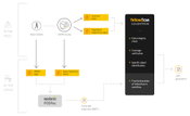
CloudStation, the New Software by YellowScan
YellowScan, the UAV LiDAR Solutions leader, announced today the release of its new software. CloudStation provides a complete solution to create and manipulate point-cloud data. It allows to extract, process and display data immediately after flight acquisition. The auto-generation of flight lines and the production of LAS files are now done in a few clicks. “This launch is an exciting move for YellowScan, it allows a better and simplified experience for the customers.” says Tristan Allouis,...
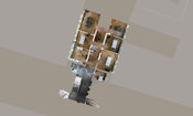
NavVis IndoorViewer 2.4: New Features Automatically Generate Highly Detailed Floorplans and Extend Routing Function
Munich, Germany – NavVis, the leading global provider of indoor spatial intelligence technology and solutions for enterprises, announces the release of NavVis IndoorViewer 2.4. This major software release includes an option to automatically generate highly detailed floorplans, enhanced routing capabilities, a new way to customize and view content and enterprise-ready security features. NavVis IndoorViewer is a web-based application that combines realistic 3D visualization of buildings with a...

Autodesk to Showcase New Unity Integration, Connected BIM at AIA 2019
Visualization and collaboration are at the heart of design, and new technologies like virtual and real-time reality, as well as cloud connectivity, have the potential to improve the way architects create and work. Tomorrow kicks off the AIA Conference on Architecture 2019, and this year Autodesk will be showcasing a new integration with Unity, as well as updates to BIM 360 Design since its debut at AIA 2018. Today, Unity announced Unity Reflect – the com...

Unity Technologies Announces Unity Reflect – First of Its Kind Product Enables Real-Time BIM Collaboration on Any Device With One Click
SAN FRANCISCO - Unity Technologies (https://unity.com), creator of the world’s most widely used real-time 3D development platform, today announced Unity Reflect: a new product which will enable Architecture, Engineering and Construction (AEC) professionals to unlock the value of BIM data by putting it directly in the hands of any user and on any device. Unity Reflect makes real-time data visualization and data collaboration possible with a Revit plug-in that exports BIM and CAD data in just one...
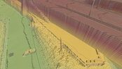
Virtual Surveyor Unveils Terrain Lenses in Drone Mapping Software
LEUVEN, Belgium – Virtual Surveyor has unveiled Terrain Lenses in Version 6.3 of its popular drone surveying and mapping software. Overlaid on a LiDAR point cloud or orthophoto, the six lenses enhance different aspects of the terrain in 3D to give users a better understanding of the topography in the area they mapped with an unmanned aerial vehicle (UAV). The Virtual Surveyor package enables professional surveyors to generate accurate topographic end products from drone data five times faster...

McCain Inc. to Unveil Transparity® TDX, at the Intelligent Transportation Society of America's Annual Meeting
VISTA, California – McCain, Inc. announced today that it will formally unveil Transparity® TDX during the Intelligent Transportation Society of America’s (ITS America) Annual Meeting in Washington, D.C., being held June 3-7. Transparity TDX (Transportation Data Exchange) will provide a new cloud-based software platform serving a network of standards compliant transportation applications and data processing services. As individual transportation systems are advancing, Transparity TDX is the answe...
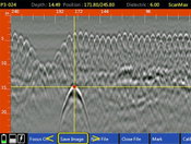
GSSI Releases Improved StructureScan™ Mini XT GPR Concrete Inspection Features with Software Update
GSSI, the world’s leading manufacturer of ground penetrating radar (GPR) equipment, announces the release of a major software update for the StructureScan™ Mini XT – the newest generation of GSSI’s popular all-in-one concrete inspection GPR system. The update expands StructureScan™ Mini XT capabilities with an increased depth range, improved Focus Mode, and a new Auto Drill feature. The update increases StructureScan™ Mini XT’s depth range by 20% to up to 24 inches for greater visibility in s...
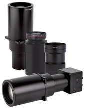
Phase One Industrial Introduces Three High Performance Lenses for High-Altitude Aerial Photography and Long-Range Aerial and Ground Inspection
COPENHAGEN – Phase One Industrial today expanded its RS and RSM lens offering with three new high performance lenses for high-altitude aerial photography and long-range aerial and ground inspection applications. The 300mm AF, 180mm, and 150mm MK II lenses are designed to enhance the performance and flexibility of Phase One Industrial’s iXM-RS and iXM aerial camera series. Each offers precision imagery, taking advantage of the cameras’ ultra-high resolution backside-illuminated (BSI) CMOS sensors...
Video: Crashes Drop Measurably After Rural Road Safety Improvement Project on US 521 in Lancaster County

AdventHealth Weaverville Hospital

June Issue 2026
.jpg?width=225)