
New Technical Document Addresses Suitability of CPVC Piping Systems For Commercial Building Applications
Available free on PPI’s website, TN-62 “Suitability and Fitness of CPVC Piping Systems for Commercial Building Applications” describes material advantages and capabilities that should be considered when designing CPVC systems for commercial plumbing and mechanical systems IRVING, Texas – April 8, 2020 - The Plastics Pipe Institute, Inc. (PPI), has published a new guide related to the use of CPVC piping systems in commercial buildings. Available on PPI’s website, TN-62 “Suitability and F...

GSSI Releases PaveScan® RDM 2.0 Asphalt Density Assessment Tool
GSSI, the world’s leading manufacturer of ground penetrating radar (GPR) equipment, announces PaveScan® RDM 2.0 – an innovative asphalt density assessment tool that provides accurate real-time measurements to ensure pavement life and quality. GSSI unveiled PaveScan® RDM 2.0 for the U.S. and Canada at the Transportation Research Board 2020 Conference in January. PaveScan 2.0 incorporates a new sensor design built specifically for the extremes of the asphalt paving environment, foldable deploym...

Woolpert, Esri Develop Free Airport FEMA Reimbursement Application
The application will help airports submit forms to expedite FEMA reimbursements. DAYTON, Ohio (April 3, 2020) — Woolpert and Esri have partnered to develop a free, user-friendly application to help airports enter, track and submit reimbursable expenses to the Federal Emergency Management Agency (FEMA). The FEMA Reimbursement Toolkit is accessible via desktop, tablet or mobile device. It will support all FEMA-related reimbursements, including COVID-19 costs, to repay 75 cents on the dollar f...

Taskade: Real-Time Collaboration Platform Launches Free Pro During COVID-19
San Francisco, CA — Taskade, a Y-Combinator backed startup, launches a real-time organization and collaboration platform for distributed teams. This week, it announced it will be offering a 6-month free upgrade to its Pro version to support businesses and individuals adopting remote work amidst the COVID-19 situation. Taskade is a real-time workspace for remote teams to manage tasks, write notes, and video chat together, on the same page. In the past few weeks, the world has witnessed an u...

elec calc™ 2020: Electrical Calculations Made Easy
Trace Software International announces that the latest version of elec calc™ is already available on the market. The software guarantees the optimal sizing and the calculation performance in real-time of any electrical installation. The newest version has been enhanced with new automation features, the result of the company’s decades of know-how in the industry. Since 1987, Trace Software International has focused its efforts on designing software solutions to help engineering professionals e...

Newest Virtual Surveyor Software Highlights Dangerous Slope Angles in Sand Pits, Quarries, Escarpments
Focus on Safe Operations AARSCHOT, Belgium – Virtual Surveyor has introduced a new feature in Version 7.2 of its popular drone surveying software that automatically highlights terrain slopes that exceed dangerous steepness thresholds. Called Slope Threshold lens, this capability significantly enhances the safety of operations in sand pits, quarries and other dynamic environments with steep terrains. “With the click of a button, operators of sand pits and quarries can see precisely where the...
InnerSpace Announces inFORCE Public Health & Safety Solution
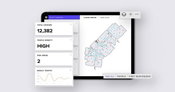
Indoor location platform provides municipalities with emergency response and public safety solutions on existing WiFi networks TORONTO (ON) - InnerSpace, the world’s most accurate WiFi-based indoor location intelligence platform, today announced its product capabilities to support all levels of government to analyze the patterns and movement in public spaces using existing WiFi networks. The platform is ideally suited to understand the movement of p...

Leica Geosystems announces new 3D laser scanning bundle
Leica Geosystems, a Hexagon company, announced today a new 3D laser scanning bundle for the BLK360 and greater integration with Autodesk ecosystem. HEERBRUGG, Switzerland – Leica Geosystems, a Hexagon company, announced today a new 3D laser scanning bundle for the Leica BLK360 and greater integration with Autodesk ecosystem. This new bundle consists of the Leica BLK360 imaging laser scanner, Leica Cyclone REGISTER 360 (BLK Edition) desktop software, and Leica Cyclone FIELD 360 for tab...

Plexscape’s response to COVID-19 pandemic: Free Plex.Earth licences for remote working
In response to COVID-19 pandemic, Plexscape, developers of Plex.Earth®, one of the most popular AutoCAD tools for the acceleration of architectural, engineering and construction (AEC) projects, is doubling its customers’ licenses at no extra cost, for the next 3 months. This initiative aims to help thousands of Plex.Earth users in more than 120 countries worldwide to have a smooth transition to the new remote-work conditions by installing the software on their home computers or laptops, free of...

SOLV3D Embraces Market and Client Requirements in Their Latest Product Release
CALGARY, AB – March 31, 2020 – SOLV3D, a leading provider of 3D processing, geospatial data visualization and collaboration solutions, is pleased to announce the immediate availability of version 2.2.1.1937 of SOLV3D encompass™ (Encompass) and version 3.0.2 of SOLV3D engine™ (Engine). The releases incorporate a number of new features and enhancements. “Much of this release can be attributed to the feedback and input we’ve received from the many partners and clients we are working with.” stat...
Video: Crashes Drop Measurably After Rural Road Safety Improvement Project on US 521 in Lancaster County

AdventHealth Weaverville Hospital

June Issue 2026
.jpg?width=225)