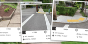
RoadBotics Introduces Image Logger on Asset Management Operating System
PITTSBURGH, PA – RoadBotics is announcing the addition of Image Logger to its growing suite of products to help communities digitize their assets including roads, sidewalks, trails, and more. This innovative technology places time-stamped geo-spatial image data on a GIS-enabled map, creating an easy way for communities to view all of their public assets on one platform. Viewable from a desk or out in the field, Image Logger maps simplify decision making, saving users time and money. “The Im...

Monograph Launches New Forecasting Features
Firm management software provides comprehensive project status and budgeting tools for AEC firms San Francisco, CA — June 2020 — Monograph, a San Francisco-based technology company innovating the way architects and engineers oversee projects, timesheets and forecasts, is pleased to announce two important software features. Designed to support connected workflows and improve forecasting capabilities, the new Project Status categorizations and Project Planner are a direct response to curre...

Ideate Software Applications Now Aligned with Autodesk Revit 2021
San Francisco, CA – Ideate Software, a veteran Autodesk Developer Network member, announced enhancements to its Revit productivity applications. “As we do every year, we launched updates to all our products shortly after Autodesk released its newest version of Revit software,” said Glynnis Patterson, Director of Software Development. “In addition to aligning our software with Revit 2021, we added enhancements requested by Revit users around the world. One of the most significant changes is wi...
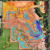
Virtual Surveyor Drone Surveying Software Simplifies Workflow for Earthworks Monitoring at Construction Sites
Fast Cut-and-Fill Calculations AARSCHOT, Belgium, 15 June 2020 – Virtual Surveyor has introduced new functionality in Version 7.3 of its popular drone surveying software to create a simplified workflow for monitoring earthworks progress at construction sites. The productive workflow enables construction managers to quickly calculate cut-and-fill changes over time for comparison with the Earthworks design plan. “Drones are an inexpensive and accurate way to monitor the movement of dirt...

CHC Navigation Introduces BB4 UAV and AlphaUni LiDAR Series
Shanghai, China - CHC Navigation (CHCNAV) announced today the launch of the new multi-rotor BB4 drone and AlphaUni 300/900/1300 LiDAR. The groundbreaking combination of the AlphaUni 300/900/1300 LiDAR and BB4 UAV solutions creates one of the most comprehensive and versatile ranges for 3D mapping and geospatial data acquisition in land, air and marine applications. "The purchase of a 3D mobile mapping system is too often constrained to a specific purpose, such as airborne or ground survey. A...

CUES New Product – GraniteNet WebInspect Browser-Based App
Orlando, Florida, USA: CUES is proud to offer GraniteNet WebInspect, a browser-based inspection app. to perform inspections and collect information about municipal assets, such as manholes, including MACP v7 Level 1, hydrants, lift stations, grease traps, light poles, signage, etc. Perform and track tasks such as valve turning, smoke tests, brush cutting, snow plowing, etc. Collect GPS points, water quality samples, flow tests, assess sewer backups, etc. - virtually any type of asset assessme...
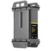
Trimble Offers New Solutions-as-a-Service Program for Remote Monitoring of Water and Wastewater Infrastructure
SUNNYVALE, Calif.,- Trimble (NASDAQ: TRMB) announced today the availability of its remote monitoring IoT hardware and software solutions offered as a service for water and wastewater utilities. With this new program, water and wastewater utilities, through a subscription, can access the latest in hardware and software technologies for remote monitoring of critical infrastructure. A New and Simplified Approach for Monitoring Critical Infrastructure As an alternative to the traditional appro...
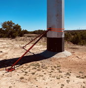
LineWise™ Introduces Pole Stabilization System for Concrete, FlowFill™ Pouring Applications
WACO, Texas — The patent-pending Direct Embed Pole Stabilization (DEPS) system from LineWiseÔ is a new bracing system for holding concrete or steel poles in place while pouring concrete or FlowFill™. This cost-effective solution offers a quick and easy setup that significantly reduces equipment and labor costs, in addition to other benefits, during the installation of direct embed poles. The DEPS system consists of two adjustable pole braces for each pole that is being stabilized. The pole br...

Arc Launches New Tools and Analytics to Support Safe, Confident Workplace Re-Entry
Arc Re-Entry provides a set of resources to help facility managers and companies as they work to put together re-entry plans for their buildings and spaces Washington, D.C. – Arc, an affiliate of the U.S. Green Building Council (USGBC), has launched Arc Re-Entry in response to the global COVID-19 pandemic. The new offering provides a set of tools and analytics designed to assist companies with re-entering their buildings and facilities. Arc is a technology platform that allows teams ove...
OnScale and Lexma Launch Moebius LBM CFD Solver for Advanced Fluid Dynamics Simulations
Silicon Valley, CA (June 9th, 2020) – OnScale, the global leader in Cloud Engineering Simulation, today announces the availability of the Moebius Lattice-Boltzmann Method (LBM) Computational Fluid Dynamics (CFD) solver on the OnScale Cloud Engineering Simulation platform. “Moebius represents a step-change in CFD speed, power, and democratization for digital prototyping of devices involving fluid flows,” says David Freed, CTO of OnScale and a Digital Physicist with a 25 year track record of ad...
Video: Crashes Drop Measurably After Rural Road Safety Improvement Project on US 521 in Lancaster County

AdventHealth Weaverville Hospital

June Issue 2026
.jpg?width=225)