
Vexcel introduces new UltraCam Eagle 4.1 photogrammetric aerial camera
Graz, Austria: Vexcel Imaging today announces the release of the new UltraCam Eagle 4.1, the pinnacle of nadir photogrammetric aerial camera systems increasing flight efficiency at truly mapping-grade image quality for precise analysis and interpretation. Based on Vexcel’s ground-breaking 4th generation camera technology, the UltraCam Eagle 4.1 collects high-resolution panchromatic, R, G, B and NIR information at over 500 Megapixels—an impressive footprint that can be exploited at different...

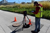
FARO Releases Focus Core Laser Scanner
Lake Mary, Fla – FARO® Technologies, Inc. (Nasdaq: FARO), a global leader in 4D digital reality solutions, today announced the release of the FARO® Focus Core Laser Scanner. The new Focus Core broadens the Focus family’s potential range of applications by providing the ideal combination of price and performance on the market. Fully integrated into FARO’s workflow solutions for application-specific insights, Focus Core uniquely serves the company’s key markets in construction, building operations...
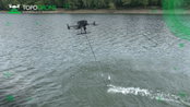
TOPODRONE advances airborne bathymetric surveying with AQUAMAPPER launch at INTERGEO 2022
Montreux, Switzerland – TOPODRONE, a Swiss based designer and manufacturer of high-precision LiDAR equipment for installation on drones, vehicles and backpacks, launches AQUAMAPPER, a UAV-based solution for bathymetric surveying and marine construction. The new multitasking data collecting device and TOPODRONE LiDAR ULTRA equipment have been successfully used together for airborne surveying at a highway construction project in Romania, EU to deliver a full digital twin of a studied area. AQU...
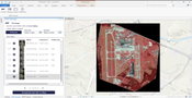
UP42 Launches ArcGIS Pro Add-in as Part of Esri Partner Network
ArcGIS users have direct access to the UP42 platform for easier data visualization and analysis BERLIN, Germany – UP42 made the first major announcement of its new partnership with the introduction of the UP42 ArcGIS Pro Add-in. Available on the Esri ArcGIS Marketplace, the UP42 add-in allows users to access UP42 data sets and projects from within ArcGIS Pro. UP42, a Silver Partner in the Esri Partner Network (EPN), unveiled the add-in today in stand C1.020 at the INTERGEO 2022 Conference...

Emesent launches three time saving products for geospatial professionals
Hovermap ST-X, the newest edition of Emesent’s award-winning Hovermap autonomy and mapping device, captures detailed, accurate data over a greater area in less time. Hovermap ST-X, Long Range Radio, and Emesent’s Aura software platform were launched at INTERGEO, providing a versatile combination to scan large areas and complex assets in less time and visualize the results in full detail. Emesent, World leader in drone autonomy, LiDAR mapping, and data analytics today launched thr...
Aries Industries Bolsters Product Offerings With Addition of RinnoVision Manhole Inspection Solutions
Company’s camera system provides safe, highly-efficient infrastructure inspections CONTACT: Jim Kraschinsky, Aries Industries, (262) 446-5620, [email protected] Waukesha, Wis. – Aries Industries, the industry leader in state-of-the-art equipment for inspection and maintenance of underground infrastructure, has expanded its broad products line with the addition of RinnoVision’s powerful manhole inspection solutions. The partnership grows Aries Industries’ ability to pro...
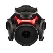
Teledyne announces new Ladybug6 cameras for high accuracy 360-degree spherical image capture
Richmond, CANADA ─ Teledyne FLIR Integrated Imaging Solutions is pleased to announce the all new Ladybug6— the latest addition to its field proven Ladybug series. Ladybug6 is the leading high-resolution camera designed to capture 360-degree spherical images from moving platforms in all-weather conditions. Its industrial grade design and out-of-the-box factory calibration produces 72 Megapixel (MP) images with pixel values that are spatially accurate within +/- 2 mm at 10-meter distance. “The...

Vectorworks, Inc. Offers New Industry-Specific Professional Certification Courses
Online Training Courses Offer an Innovative way to Advance Designers’ Careers. Columbia, MD — Global design and BIM software provider Vectorworks, Inc. invites designers to take the next step in their careers with the new professional certification course program for Vectorworks Architect, Landmark and Spotlight. The comprehensive courses are available to all users across the globe and cover the essential tools, commands and concepts needed to increase proficiency in Vectorworks' indust...

Allplan 2023: The Multi-Material Solution for Ultimate Buildability
New version allows interdisciplinary AEC teamwork on a single platform. Copyright: ALLPLAN New version allows interdisciplinary AEC teamwork on a single platform / Coordination of materials and construction methods / Superior BIM workflows and real-time collaboration Munich - ALLPLAN, provider of BIM solutions for the AEC industry, launches the new version of its BIM software Allplan 2023. As a connecting platform for interdisciplinary collaboration between architects, engineers, prec...

Warren Controls Highlights 1800N Series Valves
Heavy-Duty Globe Valves Serve a Variety of Applications Bethlehem, PA – Warren Controls, a leading manufacturer of control valves and specialty fluid handling products, highlights its 1800N series heavy-duty globe valves. These valves can be supplied in conformance with a variety of MIL-V-18030 service applications, including high pressure differentials, corrosive materials, liquids, gasses, steam, and seawater. The 1800N series provides either modulating or on/off control in either 2-way...
Video: Crashes Drop Measurably After Rural Road Safety Improvement Project on US 521 in Lancaster County

AdventHealth Weaverville Hospital

June Issue 2026
.jpg?width=225)