
StormTrap’s New Stormwater Treatment Device, StormSettler, Receives New Jersey Department of Environmental Protection Certification Under Latest Protocol
StormSettler, developed by StormTrap, is a highly efficient stormwater treatment settling device that improves the quality of stormwater runoff. ROMEOVILLE, Ill.- StormTrap® announced today the release of the new stormwater treatment device, StormSettler™. The patent-pending treatment device, designed to remove sediment from stormwater runoff, has received New Jersey Corporation for Advanced Technology (NJCAT) verification and NJDEP Certification for online and offline use after...

Simpson Strong-Tie Introduces Titen HD® Heavy-Duty Mechanically Galvanized Screw Anchor, Code Listed for Exterior Environments
Pleasanton, Calif. — Simpson Strong-Tie, the leader in engineered structural connectors and building solutions, has introduced the Titen HD heavy-duty mechanically galvanized screw anchor, a code-listed way to provide high anchoring strength in both interior and exterior applications. Designed for use in cracked and uncracked concrete, as well as uncracked masonry, this new expansion of the Titen HD line is a cost-effective and highly versatile anchoring solution ideal for si...
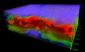
Golden Software Adds Powerful New 3D Subsurface Visualization Functionality to Surfer® Surface Mapping Package
Interpolate and visualize 3D data, such as subsurface soil or groundwater contamination, mineralization concentration, seismic refraction velocity, temperature distribution, or dissolved oxygen concentration. GOLDEN, Colorado – Golden Software’s Surfer package, long known as the geoscience profession’s most powerful 3D surface mapping software, now provides robust subsurface visualization and modeling functionality. In the latest Surfer release – available today – Golden Software has inc...

Esri Releases New ArcGIS Reality Software to Capture the World in 3D
ArcGIS Reality Enables Site, City, and Country-wide 3D Mapping for Digital Twins REDLANDS, Calif.— Business, government, and science organizations increasingly rely on drones, crewed aircraft, and satellites to capture imagery. Detailed imagery data provides visibility into operations and opportunities, unpacking information from every pixel and transforming static pictures into dynamic digital representations of the world. 3D models and high-resolution maps of construction sites, compl...
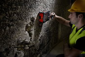
GSSI Showcases GPR Technology at Con Expo 2023
Geophysical Survey Systems, Inc (GSSI), the world’s leading manufacturer of ground penetrating radar (GPR) equipment, will be showcasing its GPR equipment at Con Expo, March 14-18, 2023 in Las Vegas, Nevada. In booth #N12921 GSSI will display its UtilityScan® system, StructureScan Mini XT, and PaveScan RDM 2.0 for the utility, concrete, and transportation industries. The UtilityScan® system makes locating and marking the depth of underground utilities in real-time in the field easier. With r...

Innovations improve field productivity and subcontractor management for better cost and schedule certainty
Newest enhancements to InEight’s construction project management platform bring better forecasting accuracy, improved field collaboration, and more visibility and control over subcontractor performance. SCOTTSDALE, Ariz. – InEight Inc., a global leader in construction capital project management software, has announced its latest suite of software innovations, which are designed to increase forecasting accuracy, field productivity, and subcontractor management. These latest updates pr...

Watson-Marlow announces new Qdos 60 PU pump with advanced polymer metering capabilities
The new Qdos 60 PU has a pumphead with a polyurethane tubing element. The dosing process is regulated by an external control system. With an expanding market worldwide for advanced polymer dosing systems, the introduction of the Qdos 60 PU peristaltic pump from Watson-Marlow Fluid Technology Solutions (WMFTS) is a timely addition to the company’s range. It means operators can now deploy efficient, safe, and reliable polymer metering at any water or wastewater treatment plant. Polymers...
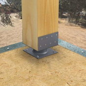
Simpson Strong-Tie Introduces New Elevated Column Base Ideal for Stacked Balconies in Multifamily Construction
Pleasanton, Calif. — Simpson Strong-Tie, the leader in engineered structural connectors and building solutions, has introduced the Simpson Strong-Tie® ECB elevated column base, which features added standoff height that makes it easy to install waterproofing and lightweight concrete topping when connecting column or post bases in multifamily construction. A continuation of the Simpson Strong-Tie ECBQ design first launched in 2011, the new ECB elevated column base features a two-inc...
Presagis Introduces VELOCITY 5D Plugin for Unreal Engine
Enables Geospatially Accurate 3D Simulations with Digital Twins Montreal, Canada — Presagis, developer of the VELOCITY 5D (V5D) digital twin production platform, today announced availability of the V5D Plugin for Unreal Engine, the most powerful 3D computer graphics engine on the market today. The plugin enables users to load a GIS-generated V5D digital twin into Unreal Engine to create highly realistic visualizations and simulations of entire cities and even countries. “The primary applic...
Esri Space Act Agreement with NASA
More NASA-Published Earth Science Data Services Will Be Accessible in ArcGIS Living Atlas of the World REDLANDS, Calif.— The science community at large is undertaking critical work, researching solutions to the world's most pressing challenges, many of which require a geographic approach. The ability of scientists and researchers to make informed decisions related to these challenges—from natural disasters to climate change mitigation—relies heavily on accessible, authoritative geospatia...
Video: Crashes Drop Measurably After Rural Road Safety Improvement Project on US 521 in Lancaster County

AdventHealth Weaverville Hospital

June Issue 2026
.jpg?width=225)