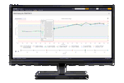
Trimble Monitoring Software Expands Sensor Support to Deliver Broader Rail and Structural Deformation Analytics for Survey, Monitoring and Construction Professionals
Trimble 4D Control increases flexibility, ease of use and security BERLIN, Germany – Trimble (NASDAQ: TRMB) announced today at the INTERGEO conference the latest release of Trimble® 4D (T4D) Control™ software, version 6.5, expanding rail track monitoring capabilities to address a wider range of standards and specifications. This update also adds support for Syscom Instruments acceleration sensors for event-based monitoring of ground motion, as well as updating authentication methods for...

Vectorworks, Inc. Announces a Colorful Update to its 2024 Product Line
Vectorworks 2024 Update 1 Includes an Innovative NCS+ Pro Integration, User Experience Enhancements and New Feature Improvements. Columbia, MD (October 11, 2023) — Global design and BIM software provider Vectorworks, Inc. has released its first update for the Vectorworks 2024 product line, unveiling a new partnership with NCS Colour, the leading provider of color communication solutions and delivering updates designed to enhance user experience and introduce improvements to newly added...

Revolutionizing 3D Scanning Data Capture, FARO Unveils Orbis Mobile Scanner
The first-to-market hybrid scanner offers mobile and stationary scanning in one device LAKE MARY, Fla.- FARO® Technologies (Nasdaq: FARO), a pioneer in the field of 3D measurement, imaging, and realization technology is proud to announce the release of the FARO® Orbis™ Mobile Scanner, a groundbreaking advancement set to redefine 3D reality capture. Orbis is the first to market hybrid SLAM scanner that can be used for both mobile and stationary data capture in one device. Offering local or c...

Trimble Launches New IonoGuard Technology to Mitigate Costly GNSS Signal Interruptions
Next-gen technology improves accuracy, availability and integrity of GNSS signals WESTMINSTER, Colo., Oct. 10, 2023 -- Trimble (NASDAQ: TRMB) introduced today Trimble IonoGuard™, a next-generation technology designed to mitigate ionospheric disruptions in positioning and navigation by minimizing performance impacts caused by scintillation or signal noise. Referred to as solar activity, ionospheric disturbances peak every 11 years. The next major disruption, Solar Cycle 25, is expected...
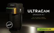
Vexcel Imaging announces the new UltraCam Dragon 4.1, a game-changing hybrid oblique imaging and LiDAR system
Graz, Austria • October 10, 2023 Live from Intergeo 2023 in Berlin: Vexcel Imaging is thrilled to announce the innovative UltraCam Dragon 4.1, representing the market's most advanced, progressively designed, and seamlessly integrated hybrid aerial mapping system. Designed for high-resolution mapping of complex urban environments and the creation of precise digital twins, the UltraCam Dragon combines the very best in imaging and LiDAR technologies for maximum collection productivity, high-accur...
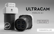
Vexcel Imaging introduces new UltraCam Merlin 4.1 aerial camera system for elevated profitability and performance
Graz, Austria • October 10, 2023: From the Intergeo 2023 in Berlin, Vexcel Imaging today announces the launch of the new UltraCam Merlin 4.1, an advanced camera system currently available in two models serving as a gateway to professional aerial data collection. Equipped with high-end Bayer pattern sensors, the UltraCam Merlin 4.1 meets the fundamental quality and accuracy standards demanded by professionals in the field. The system captures true nadir imagery at industry-leading geometry and...

LocLab Makes Digital Twins More Accessible with the Launch of LocLab Cloud, Powered by HxDR
LocLab Cloud is an end-to-end solution providing an innovative new way for using, managing and sharing 3D digital twins. (Darmstadt, Germany, Oct. 9, 2023) LocLab, part of Hexagon, today announced the launch of LocLab Cloud, powered by HxDR. The cloud-based platform offers a secure end-to-end solution for 3D digital twins, allowing management and monitoring of models. It acts as an open platform, enabling partners to upload, update, access and share their own digital 3D content. Generic inter...
Flow Labs and TomTom Announce Major Data Partnership to Bring Agencies Unprecedented Traffic Data Accuracy
Flow Labs’ proprietary AI digital twin platform paired with TomTom’s data will deliver new levels of data accuracy and reliability. By increasing probe data access by more than 5x, this partnership will build the foundation of powerful AI applications that will deliver real-time optimization and insights to transportation agencies across the US. OAKLAND, California – Flow Labs, a transportation software technology leader specializing in Artificial Intelligence (AI) and transportation dat...
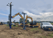
Trimble and Mincon Offer Trimble Ready Drilling and Piling Solution for Solar Industry
WESTMINSTER, Colo.—Trimble (NASDAQ: TRMB) announced today the availability of a Trimble Ready® factory option for new Mincon piling and drilling attachments. As a result of this collaboration, Mincon Drill Mast Attachments for skid steers and excavators now have an option for the installation of the Trimble® Groundworks Machine Control System, which can significantly reduce the cost and complexity of the installation for the contractor. Mincon Solar Installation Drills and Pile Drivers are de...
Topcon expands construction layout portfolio with LN-50
LIVERMORE, Calif. – October 4, 2023 – Topcon Positioning Systems announces the launch of the LN-50 3D laser, the latest addition to the LN layout navigator family of instruments. Intended to be an affordable and easy-to-use solution for digital layout, the LN-50 has a 50-meter (164-foot) range as compared to the longer-range, full-featured LN-150 that continues to be a mainstay of the Topcon layout portfolio. The new LN-50 is designed specific to homebuilders, mechanical, electrical, plumbing (M...
Video: Crashes Drop Measurably After Rural Road Safety Improvement Project on US 521 in Lancaster County

AdventHealth Weaverville Hospital

June Issue 2026
.jpg?width=225)